Overview

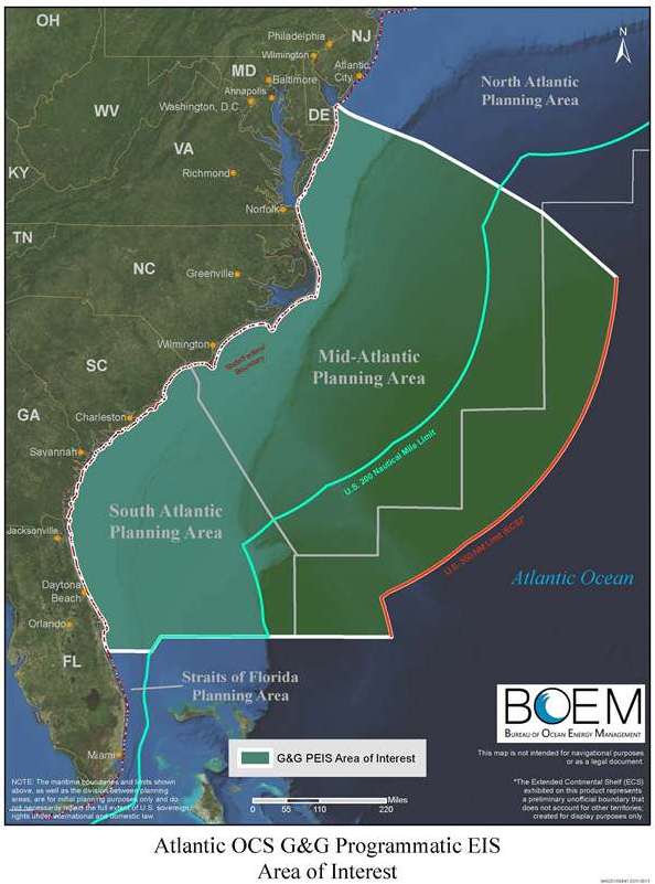
In March 2014, BOEM published a Programmatic Environmental Impact Statement (PEIS) to evaluate potential significant environmental effects of multiple geological and geophysical (G&G) activities on the Atlantic Outer Continental Shelf (OCS), pursuant to the National Environmental Policy Act (NEPA). BOEM issued this PEIS to describe and evaluate the potential environmental impacts of G&G survey activities in Federal waters of the Mid- and South Atlantic OCS and adjacent state waters. The PEIS examines G&G survey activities for three program areas (oil and gas, renewable energy, and marine minerals) for activity levels projected between 2012 and 2020. The PEIS evaluates impacts to Atlantic resources that could occur as a result of G&G activities, and identifies mitigation and monitoring measures to avoid, reduce, or minimize impacts.
The PEIS was prepared upon direction of the Congress because BOEM currently has no programmatic NEPA coverage for permitting G&G activities in Atlantic OCS waters. BOEM has received several permit requests for seismic airgun surveys in support of oil and gas exploration, and industry has expressed interest in expanding activities into Atlantic offshore waters. The PEIS establishes a framework for future NEPA evaluations of site-specific actions, while identifying and analyzing mitigation measures for future programmatic use.
About the Proposed Action
The proposed action is to permit G&G activities in support of oil and gas exploration and development, renewable energy development, and location and distribution of marine minerals in the Mid- and South Atlantic Planning Areas. The purpose of the proposed action is to gather data to image the ocean bottom and subsurface geology. These data would provide information about the location and extent of oil and gas resources, seafloor conditions for oil and gas or renewable energy infrastructure, and marine minerals deposits off the U.S. Atlantic coast. G&G data and information are required for business decisions for prospecting OCS oil and gas in an orderly manner, assessing sites for renewable energy facilities, or identifying the location of marine mineral resources in the area. The quality of G&G data in surveys acquired during the period when Atlantic oil and gas leasing took place in the 1970s and 1980s has been eclipsed by newer instrumentation and technology that make seismic data of that era inadequate for business decisions to lease and develop these OCS lands or to evaluate the environmental impacts of leasing and development.
The need for the proposed action is to use the information obtained by G&G surveys to make informed business decisions regarding oil and gas resources, engineering decisions regarding the construction of renewable energy projects, and informed estimates regarding the composition and volume of marine mineral resources.

Map above is available for PDF download in (11 x 17) and (8.5 x 11).
Record of Decision (ROD)
- Notice of Availability - Federal Register
- Record of Decision
Final PEIS
- Notice of Availability - Federal Register
- Special Information Sheet - Notice of Availability Final Programmatic Environmental Impact Statement Atlantic Outer Continental Shelf Proposed Geological and Geophysical Activities Mid-Atlantic and South Atlantic Planning Areas
- Volume I: Chapters 1-8, Figures, Tables, and Keyword Index
- Volume II: Appendix A
- Volume III: Appendices B-M
- Final Biological Opinion
- Acoustic Modeling and Marine Mammal Incidental Take Supplemental Tables
Draft PEIS
- Federal Register Notice of Availability for the Draft PEIS (March 30, 2012)
- Federal Register Notice extending public comment period by 30 days (June 4, 2012)
- Draft PEIS Volume I
- Draft PEIS Volume II
- Public Comments Received -
- Biological Assessment
- Draft PEIS Addendum - Keyword Index
- Draft PEIS Supplemental Seismic Take Tables
Additional Information
- 2009 Federal Register Notice announcing a Notice of Intent to prepare an Environmental Impact Statement for Atlantic G&G activities
- 2010 Federal Register Notice announcing Atlantic G&G scoping meetings and comment period
- Atlantic G&G PEIS scoping meetings PowerPoint presentation (April 2010)
- A Brief History of the Use of Sound in Ocean Exploration:
https://www.usgs.gov/centers/whcmsc/science/sea-floor-mapping-group - A Brief Tutorial on Seismic Technology and How it is Used:
https://www.usgs.gov/centers/whcmsc/science/sea-floor-mapping-group

