MarineCadastre.gov Team to Receive Nebert National Spatial Data Infrastructure Award
The Bureau of Ocean Energy Management and National Oceanic and Atmospheric Administration’s Office for Coastal Management are honored to announce that the Federal Geographic Data Committee has selected the MarineCadastre.gov team to receive the 2017 Doug D. Nebert National Spatial Data Infrastructure (NSDI) Champion of the Year Award. The FGDC plans to present the award in summer 2018.
Team members of MarineCadastre.gov being recognized are: From the Department of Interior, Bureau of Ocean Energy Management (BOEM):
- Christine Taylor, Frank Pendelton, Josh Wadlington, Jim Fulmer (retired)
From the Department of Commerce, National Oceanic and Atmospheric Administration (NOAA):
- Dave Stein, Mark Finkbeiner, Cindy Fowler (retired), and NOAA contractors Adam Bode, Jesse Brass, Nikki Brock, Lindsay Goodwin, Daniel Martin, Caitlyn McCrary, Jodie Sprayberry, Megan Treml, and Anna Verrill.
The team members, dispersed between six locations around the Nation, manage MarineCadastre.gov, a geographic information system containing authoritative data that are fundamental to supporting decisions about the development of the Nation’s offshore conventional and renewable energy resources, use of Outer Continental Shelf (OCS) sand and gravel for shore protection, beach nourishment, and wetlands restoration projects, and ocean coordination and planning efforts. This effort is a partnership between the Department of the Interior’s Bureau of Ocean Energy Management and the Department of Commerce’s National Oceanic and Atmospheric Administration’s Office for Coastal Management, with support from many other federal, state, and regional data providers.
“The collaboration between BOEM and NOAA to build and manage this extraordinary platform has had a huge, positive impact on the ability of our agencies, and others active in managing ocean resources, to carry out their missions,” said BOEM Acting Director Walter Cruickshank. “MarineCadastre.gov has changed the way we do business for the better, and we greatly appreciate the team’s dedication in serving the nation.”
"This tool continues to play an important role in the successful management of our nation's ocean resources," said Jeff Payne, director of NOAA's Office for Coastal Management. "We are honored to have won this award, and excited to have been able to play a role in this monumental endeavor. In light of the increased interest in our nation's ocean, this tool is especially relevant."
“This award honors Doug Nebert, who was a respected FGDC colleague, technical visionary, and recognized national and international leader in the establishment of spatial data infrastructures,” said FGDC’s Acting Chair, Andrea Travnicek, Ph.D of the Department of the Interior in announcing the selection.
MarineCadastre.gov provides data, web maps, and specialized tools that are used by stakeholders to address national issues in the areas of energy infrastructure planning; ocean vessel navigation and safety; national defense; conflict avoidance involving ocean users; and maritime jurisdictions and limits. The system was originally created to comply with Section 388 of the Energy Policy Act of 2005 to inform OCS alternative energy development. Since then, it has evolved, and in addition to maintaining information necessary for the siting of offshore energy structures, it provides the geospatial framework needed for broader coastal and ocean planning. MarineCadastre.gov is widely used by the public and private sectors, including regional ocean portals for planning and to access scientific research, such as results from BOEM’s Environmental Studies Program.
Customer feedback continuously indicates that MarineCadastre.gov is accomplishing its original goals while embodying the principles of the National Spatial Data Infrastructure and the Office of Management and Budget’s guidelines for coordination and use of spatial data (Circular A-16).
For example, Jerry Johnston, the former Geographic Information Officer for the Department of Interior and National GeoPlatform architect, said, “The work that the MarineCadastre.gov team has done by exposing their rich data via compelling and interesting maps is among the best interagency mapping efforts happening in government. This kind of collaboration is a natural fit with what we are trying to do on the Geospatial Platform—giving agencies and their partners a place where they can come together and build and share data, maps, and geospatial applications.”
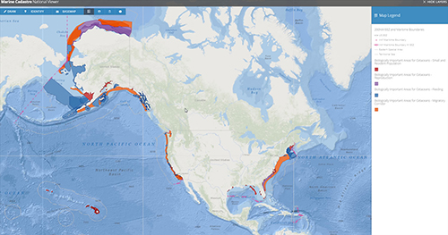
This map shows five of the 261 layers from the MarineCadastre.gov
-- Cetacean Biologically Important Areas for four different life history stages,
plus maritime boundaries. Explore the layers to make
beautiful, informative maps.

