BOEM archaeologists working with Federal, State and private partners* continue to investigate a historic wooden-hulled vessel that sank some 200 years ago.
Originally identified as a side scan sonar target in 2011 and dubbed “the Monterrey Wreck,” it is located offshore Texas in an area adjacent to Flower Garden Banks National Marine Sanctuary. In April 2012, the first reconnaissance of the shipwreck (BOEM Site 15577) was conducted by NOAA Ship Okeanos Explorer. On July 18, 2013, scientists began new exploration of the site while transmitting live video from the seafloor. Three separate shipwrecks were identified.
2014 Expedition
Video Highlights:
http://oceanexplorer.noaa.gov/okeanos/media/exstream/exstream_04.html.
April 10- May 1, 2014 - BOEM scientists again join the onshore team as ROV Deep Discoverer explores three previously identified shipwreck sites in the “Monterrey Wreck area” about 175 miles offshore Galveston, TX. A fourth identified target site may also be explored.
For more information on the 2014 mission plan visit: http://oceanexplorer.noaa.gov/okeanos/explorations/ex1402/background/shipwrecks/welcome.html
2013 Nautilus Expedition
As with many of Okeanos Explorer’s most important discoveries, the work on this shipwreck, has catalyzed follow-on research activities. In a partnership between the Meadows Center for Water and the Environment at Texas State University and the Ocean Exploration Trust, an expedition returned to the site on the E/V Nautilus from July 18 to 25, 2013.
 Scientists onboard the E/V Nautilus and ashore using telepresence technology spent a week using the ROV Hercules to carefully document, map, video and photograph the site, and recover a small number of artifacts for conservation and analysis. Information obtained will help place the vessel in its historical and cultural context to better answer questions about its age, origin, purpose and possibly who may have been aboard when it tragically sank. Science partners include the Meadows Center, NOAA (OER and ONMS), BOEM, BSEE, the Texas Historical Commission, the University of Rhode Island, State of Maryland, Texas A&M’s Conservation Research Laboratory and Texas A&M Galveston, OET, and others. The expedition leaders and onboard participants were Jack Irion (BOEM), Frank Cantelas (NOAA), James Delgado (NOAA), Frederick Hanselmann (MC), Amy Borgens (THC), Michael Brennan (OET), Chris Horrell (BSEE) and Alicia Caporaso (BOEM). Other scientists participated online and in real-time telepresence enabled command centers.
The 2013 Site 15577 project was made possible through sponsorship, grants and donations through the Meadows Center from foundations and private individuals to foster and further collaborative deepwater archaeology and science in the Gulf.
Video from the seafloor and more information about the 2013 expedition can be found at Nautilus Live.
2011 – 2012 Discovery and Exploration
First identified as a side scan sonar target in 2011, the brief remotely operated vehicle (ROV) dive made a truly exciting discovery that no one at the time knew would contribute significantly to our understanding of a turbulent period of American history.
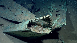
 In April 2012, NOAA Ship Okeanos Explorer conducted the first reconnaissance of the site. The shipwreck appears to be an undisturbed, early 19th century, wooden-hulled sailing vessel.
The sonar target first came to light when Shell Oil notified the Bureau of Offshore Energy Management (BOEM) and the Bureau of Safety and Environmental Enforcement (BSEE), agencies of the U.S. Department of Interior, that a side scan sonar target resembling a shipwreck had been found in their lease area. The sonar image revealed a sharp hull-formed outline measuring approximately 25 meters (84 feet) long by 7.9 meters (26 feet) wide in 1,330 meters (4,363 feet) of water.
The discovery came about because BOEM and BSEE are the Federal agencies that oversee and issue permits for oil and gas exploration and development on the Gulf Outer Continental Shelf. Under the National Historic Preservation Act of 1966, BOEM and BSEE are required to take steps that contribute to the preservation of sunken historic and archaeological properties. The oil and gas industry must follow specific BOEM guidelines for conducting surveys of the bottom using remote sensing instruments such as side-scan sonar and magnetometers before they are permitted to undertake activities that disturb the seafloor. As a result of intense oil and gas exploration in the northern Gulf more than 600 shipwrecks and possible shipwrecks have been located, mostly through these surveys.
Site 15577
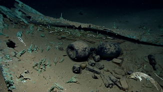
 The Okeanos Explorer’s ROV dive on the shipwreck lasted just over two hours, collecting valuable high definition video. The remains of the relatively small vessel, about 84 feet long, are outlined by the copper sheathing tacked to the lower hull put there to protect the bottom from marine bio-fouling. While wood close to the copper sheathing has survived, the entire upper portion of the wooden ship has been consumed, allowing durable artifacts, such as those made from ceramic, glass and metal, to drop to the bottom. The area of the Gulf where the site is located receives very little sedimentation, so many of the artifacts lay uncovered, mostly inside the hull.
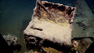
From the distribution of artifacts, we get a sense of how the vessel was organized. A large anchor in the bow was probably secured on the forward deck. Elements of the standing rigging along the length of the vessel indicate the location of the masts. A concretion of large metal objects located amidships contains an anchor, several cannon and smaller artifacts. Some or all of these items may have been stowed below deck during the voyage. A large rectangular metal stove resting on a lead sheet (to protect the wooden deck from catching fire) and food storage containers, denote the galley area where food was prepared. Further aft, near the stern, where the ship’s officers likely lived, are plates, bottles, glassware, firearms, medicine, and navigation instruments.
The baseline data collected by Okeanos Explorer’s brief visit led to considerable follow-on research by a group of archaeologists and historians. The artifacts and vessel remains suggest the site dates to the first half of the nineteenth century making it one of the more significant shipwrecks discovered in the Gulf of America to date. The site, well preserved and remarkably undisturbed, is from a critical period in history when new nations were forming at the end of Colonial era and the Gulf was opening to global trade.
Partnerships
During the Okeanos Explorer Gulf cruises, NOAA’s Office of Ocean Exploration and Research (OER) relied on BOEM and private industry to identify potential shipwreck targets for exploration. Partnerships have the obvious advantage of pooling knowledge and resources. OER and BOEM have worked as interagency partners since 2004, on a number of very successful multi-year environmental studies in the Gulf and the Atlantic which serve each agency’s missions. These are systematic studies to locate and characterize deep-water shipwrecks and habitats such as corals and seep-associated marine communities. The primary objective has been to provide information on cultural resources, biodiversity and ecology to enable informed decisions of future oil and gas development activities. Okeanos Explorer cruises provide a new avenue to continue this work and strengthen the partnership as well as providing an all-too-rare opportunity to study shipwrecks using the most advanced deep water underwater systems available. As happened with Site 15577, extraordinary discoveries often inspire new research and new partnerships increasing our knowledge of the ocean and, in this case, our shared heritage.
*Partners with BOEM in the 2012 Gulf expedition included:
- NOAA Office of Ocean Exploration and Research;
- NOAA Maritime Heritage Program;
- Bureau of Safety and Environmental Enforcement;
- C&C Technologies;
- Florida Atlantic University;
- Geoscience Earth & Marine Services;
- Louisiana State University;
- Mississippi State University’s Science and Technology Center at Stennis;
- Naval History and Heritage Command;
- Pennsylvania State University;
- Temple University;
- Tesla Offshore LLC;
- Institute for Exploration;
- University Corporation for Atmospheric Research Joint Office for Science Support;
- University of New Hampshire;
- University of North Carolina Wilmington;
- University of Rhode Island;
- University of Texas at Austin;
- Woods Hole Oceanographic Institution.
For more information on this shipwreck, see: http://www.boem.gov/press05162012/
For more Gulf of America Shipwrecks see: http://www.boem.gov/Shipwrecks/

