
Overview
The Department of the Interior (DOI) developed the Oil Spill Risk Analysis (OSRA) model in 1975 as a tool to assist in evaluating oil spill risks to environmental resources from Outer Continental Shelf (OCS) oil and gas lease sales and related activities. The first OSRA report was written in 1976 for the North Atlantic Lease Area. Today, as part of its responsibility to manage the oil and gas resources on the OCS, BOEM continues to use OSRA modeling to analyze areas that may be contacted in the event of an oil spill.
What Questions Does OSRA Answer?
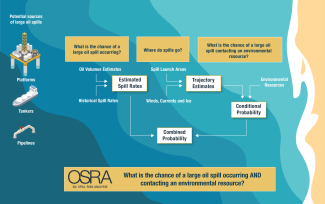
The model provides answers to three important questions:
- What is the probability of a large oil spill (greater than or equal to 1,000 barrels) occurring?
- What is the probability of a large oil spill contacting an environmental resource?
- What is the probability of a large oil spill occurring and contacting an environmental resource?
Why Does BOEM Conduct OSRA?
BOEM assesses oil spill risk associated with oil and gas development on the U.S. OCS.
BOEM conducts OSRA prior to offshore oil and gas leasing or approval of exploration and development plans.
OSRA provides results for BOEM to prepare
- Environmental impact statements and environmental assessments under the National Environmental Policy Act (NEPA)
- Records of Decision
- Potential stipulations or mitigation measures
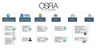
Who Uses the OSRA Results and How Are They Used?
In addition to the ways that BOEM uses OSRA results, OSRA is also used by
- National Oceanic and Atmospheric Administration to prepare Endangered Species Act analysis and Biological Opinions
- U.S. Fish and Wildlife Services to prepare Marine Mammal Protection Act analysis and Incidental Take Authorizations
- States to prepare Coastal Zone Consistency Determinations
- Oil and gas industry to prepare Oil Spill Response Plans (OSPR)
- General public and others to respond to comments on NEPA documents and OSPR
How Are Oceanography and the Atmospheric Sciences Utilized to Support OSRA?
Oceanography and atmospheric sciences play critical roles in supporting OSRA by providing the data and models necessary to predict the behavior and impact of oil spill. For example, ocean currents are crucial in determining the transport and spread of an oil spill. Tides and wave action also influence the movement of the oil. Winds play a significant role in determining the surface movement of spilled oil. OSRA models need wind data to calculate how oil will spread on the water's surface and potentially reach the coast and other environmental resources.
Oil Spill Response
For information pertaining to operational safety, pollution prevention, oil spill response, and cleanup capabilities, visit the BSEE’s Technological Assessment Program and Oil Spill Response Research.