

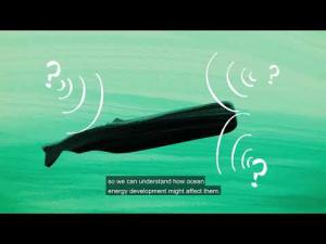
BOEM’s environmental program develops, funds and manages rigorous scientific research to inform policy decisions on offshore energy and mineral resources on the Outer Continental Shelf (OCS). For the past decade, BOEM has been harnessing citizen science to help with its decision-making efforts.
People-Powered Science
When the public voluntarily participates in scientific research, we call this process citizen science. In citizen science, members of the public might conduct scientific experiments, collect and analyze data, develop technologies – even make new discoveries. Citizen scientists share this information with researchers to help answer and address real-world problems. People-powered science is beneficial for both the public and the institutions they are assisting. It’s an engaging and educational opportunity for citizen scientists and an effective outreach tool for scientific and research organizations.
Crowdsourcing – asking large groups of people to voluntarily submit data, ideas and opinions through social media, smartphone apps and the Internet – can also help the government tackle complex problems. Tapping into crowdsourcing allows scientists to conduct research on much larger geographic scales and over longer periods of time than they could working alone.
Federal agencies have successfully used citizen science and crowdsourcing for more than a century. Congress passed the Crowdsourcing and Citizen Science Act of 2016 to encourage and increase the use of crowdsourcing and citizen science methods within the federal government. The law is intended to advance and accelerate scientific research, literacy and diplomacy and other purposes. Citizenscience.gov is the official website designed to accelerate the use of crowdsourcing and citizen science across the U.S. government. BOEM is a member.
How BOEM Uses Citizen Science
BOEM draws on citizen scientists to fill knowledge gaps about the oceans and the species and habitats within them. This data helps the Bureau plan offshore energy and mineral development in ways that lessen the potential impacts to the environment. It provides a more complete picture of marine species and habitats and ultimately makes the oceans a safer place for them.
BOEM has numerous research projects that incorporate citizen science.
Multi-Agency Rocky Intertidal Network (MARINe) Study
Monitoring marine life in rocky intertidal shore areas in a well-designed, systematic manner over long periods of time is critical to understanding these unique and dynamic communities. The Multi-Agency Rocky Intertidal Network (MARINe) program began with the goal of developing an approach that would enable researchers to collect statistically sound data using methods that were simple enough to maintain over the long-term, using minimal resources. It has grown into a consortium of groups that now monitor sites along the entire Pacific Coast of North America, from Alaska to Mexico, and several East Coast sites in Maine and New Hampshire. The MARINe program is the largest and longest-running of its kind – sites in some regions have been sampled for 20-30 years.
BOEM and its 40 MARINe partners biannually monitor over 100 established shoreline rocky intertidal sites immediately adjacent to existing OCS oil and gas platforms off California and possible future wind and wave energy facilities off the west coast. For one study, citizen science groups are helping researchers collect sea star data to better understanding sea star wasting disease.
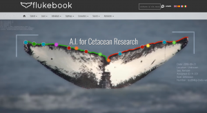
Flukebook is an online data resource using photographs to identify distinguishing markings on individual whales and dolphins. The BOEM-sponsored project applies specialized software (e.g., artificial intelligence) and computer algorithms to identify and track individual whales and dolphins across hundreds of thousands of photos – several times faster than researchers could do with the human eye. The compiled data allows researchers to track individuals to populations, and movement patterns by matching photos against known visual catalogs. Anyone can submit photographs and sighting information to Flukebook.
The Flukebook site and its companion app, Ocean Alert, were developed as part of the unique three-year BOEM-led research collaboration called the Marine Mammal Passive Acoustics and Spatial Ecology (MAPS) Project. MAPS aims to increase understanding of lesser known whale species and enhance the efficacy of gathering and sharing data across ocean scientists, policy makers, and citizen science communities.
Ocean Alert
Ocean Alert is a mobile data collection app for data sightings of marine megafauna, including sea turtles, sharks and whales. Citizens can use Ocean Alert to upload images, sightings and other species information to the app, which seamlessly feeds the data to Flukebook and other appropriate repositories for resource managers. Federal agencies can also disseminate information – such as wind turbine construction areas or speed restrictions for large whales – to the boating public in real time, making dynamic ocean management a reality.
Ocean Alert is also part of the Marine Mammal Passive Acoustics and Spatial Ecology (MAPS) Project, a cooperative agreement between BOEM and the University of North Carolina Wilmington. MAPS draws on the expertise of researchers and citizen scientists to fill knowledge gaps about the distribution and behavior of sperm, beaked and sei whales. Ocean Alert has been developed in partnership with engineers at Conserve.IO, Wild Me and pilot tested by NOAA’s Channel Islands National Marine Sanctuary and members of their Channel Islands Naturalist Corps citizen science program. Ocean Alert is an outgrowth of the pioneering Whale Alert software application developed at Stellwagen Bank National Marine Sanctuary. It is available for free on Apple’s App Store.
Belugas Count!
Belugas Count! is a collaborative effort that encourages citizen scientists to gather information on beluga whales in Alaska. Each year, the public scans and counts beluga whales in the Cook Inlet from multiple observation stations. The National Marine Fisheries Service, also known as NOAA Fisheries, collects this data as part of the Cook Inlet Beluga Whale Recovery Plan. BOEM’s environmental analyses consider potential impacts that permitted activities could have on the beluga whales. BOEM partners with NOAA Fisheries on the event to help raise awareness of the species and our role in protecting it. A Belugas Count! video is also available.
Local Environmental Observer (LEO) Network
Local observers are often the first people to notice and report changing environmental conditions or anomalous events. The Local Environmental Observer (LEO) Network is a BOEM-sponsored project developed through the Alaska Native Tribal Health Consortium. It is a network of local observers and topic experts who share knowledge about unusual animal, environment, and weather events. BOEM monitors these observations to stay informed on events that provide evidence of environmental change or conditions that we should consider in our environmental analyses.
The LEO App is a mobile and web data collection application that allows members to share their own observations with the network and relevant area experts. Monthly webinars discuss recent observations and overall trends in the data.
Cross Island Whale Monitoring
BOEM has partnered with whaling crews from Nuiqsut, Alaska to record whalers’ observations during annual bow head whale subsistence hunts at Cross Island and combine that information with GPS technology. Acquiring and applying Nuiqsut citizens’ traditional knowledge of the whales and ocean environment provides BOEM with a more complete understanding of the potential impacts of proposed projects and helps avoid conflicts with subsistence practices.