
The National Offshore Sand Inventory investigates where useful OCS sediments are located, what quantities are available, and how we can manage them sustainably to help restore and protect the coast.
More about our research:
What is NOSI?
The BOEM National Offshore Sand Inventory (NOSI) is an information resource and comprises a business process designed to support coastal resilience over the 21st century and promote continued stewardship of a finite, critical resource.

NOSI is a Business Process
NOSI ensures continual resource definition and refinement from unverified to proven resource, from proven reserve to optimized borrow area use and stewardship.
- Helps optimize resource use to promote efficiency
- Facilitates space planning and multiple use conflict resolution
- Supports responsible management including conservation of resource and prevention of waste
- Leverages federal and state resources towards a common objective
NOSI is an Information Resource
NOSI ultimately describes the character, quantity, and location of sand and sediment resources on the OCS. NOSI relates sediment supply to project demand within the context of the underlying geologic framework and regional sediment processes of the coastal compartment for which they are found.
Business Process
- Determine Need:
Where do we need to investigate and why?
- Acquire Data:
How can we leverage existing data? Where and what type of new data can we collect?
- Analyze Results:
What conclusions can we draw and what decisions can we make with the data?
- Share Findings:
How can we provide usable and discoverable ways of accessing the data, results, and implications?
NOSI Research Priorities
- Supply and Demand:
Assessments that compare the offshore sand and sediment resources identified or projected to the sand and sediment volumes required for nearby coastal areas.
- Resource Evaluation:
Research focused on geologic framework or sediment budget.
- Risk Mitigation:
Research geared towards understanding ocean use, operational constraints, or environmental considerations.
- Borrow Optimization:
Research related to borrow area performance monitoring and recovery, reserve management, and technological advances for identification or extraction of marine mineral resources.
Access NOSI’s Findings
NOSI is committed to disseminating its findings to stakeholders. Through our research and reports, interactive tools, and the Marine Minerals Information System (MMIS) Viewer, NOSI makes critical data accessible to coastal managers, researchers, and the public. This transparency fosters collaboration and informed decision-making, empowering communities to take action based on our research and studies.
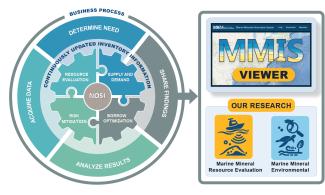
Want a deeper look into the Marine Minerals Program data holdings?
Discover what we put from our reports and findings into the MMIS Viewer. This easy-to-use platform lets you explore our data about marine minerals, encouraging transparency and teamwork in managing these resources.