
The following maps are a sampling of maps that are created by research performed through BOEM’s Environmental Studies Program. Search and view all of the studies reports in the Environmental Studies Program Information System (ESPIS).
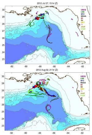
Four-day trajectories of the different drifter groups released by the GLAD cruise including SPOT, flat surface drifters, NOAA, meteorological (MET) drifters and drifters released by the US Coast Guard. The S1, S2, T1, L1 and L2 clusters were released in a fractal configuration Figure 2.11 from OCS Study BOEM 2014-053: Implementation of Lagrangian Stochastic Models to Parameterize Submesoscale Transport for Tracking Oil Spills in the Gulf of America
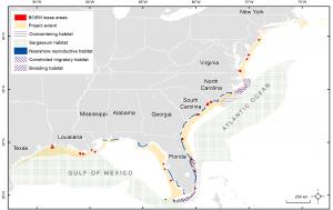
Northwest Atlantic Ocean loggerhead Caretta caretta critical habitat and the extent within the Atlantic and Gulf OCS where hopper dredges may operate in association with BOEM lease areas Figure 2 from OCS Study BOEM 2017-084: Review of Sea Turtle Entrainment Risk by Trailing Suction Hopper Dredges in the US Atlantic and Gulf of America and the Development of the ASTER Decision Support Tool
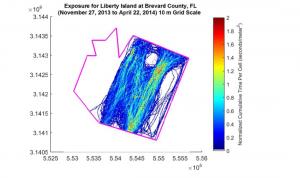
Example Exposure with cell size of 10 m using dredging drag arm data from the Liberty Island Figure 19 from OCS Study BOEM 2018-019: Using Dredge Plant Operational Data to Measure Dredging Intensity and Cumulative Exposure
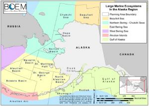
Large marine ecosystems and planning areas in the Alaska Region
Figure 5 from OCS Study BOEM 2018-067: Forecasting Environmental and Social Externalities Associated with Outer Continental Shelf (OCS) Oil and Gas Development, Volume 2: Supplemental Information to the 2018 Revised Offshore Environmental Cost Model (OECM)