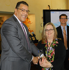
Congratulations to our colleagues at BOEM and NOAA for receiving the 2017 Doug D. Nebert National Spatial Data Infrastructure (NSDI) Champion of the Year Award from the Federal Geographic Data Committee during a U.S. Department of the Interior ceremony on July 26, 2018.
Ivan DeLoatch, Executive Director of the FGDC, presented the award to Christine Taylor of BOEM’s Office of Strategic Resources, and David Stein and Mark Finkbeiner from NOAA’s Office for Coastal Management, on behalf of the 16-person team. “We appreciate the leadership of both BOEM and NOAA in exhibiting exemplary values in managing geospatial data and technology for MarineCadastre.gov, an amazing GIS mapping system for ocean uses,” DeLoatch said.
 The award honors Doug Nebert, who was a respected FGDC colleague, technical visionary, and recognized national and international leader in the establishment of spatial data infrastructures.
MarineCadastre.gov is a dynamic system containing authoritative geospatial data that are fundamental to the business decisions about the Nation’s offshore energy and ocean activities, including BOEM’s offshore conventional and renewable energy programs, and its marine minerals program that manages sand and gravel for infrastructure protection and coastal restoration. BOEM’s Environmental Studies Program provides access to its scientific research through the Cadastre platform, and many other organizations link their data portals to the Cadastre.
On June 19, 2018, the President recognized the Marine Cadastre in a new executive order on ocean policy, noting that the system can help to implement the policy set forth by the order to advance the economic, security and environmental interests of the United States.
The partnership between BOEM and NOAA includes support from 17 other federal data providers. MarineCadastre.gov provides data, web maps, and specialized tools and has been used by agencies to address national issues in a number of critical areas, including energy infrastructure planning, ocean vessel navigation and safety, and public hazard exposure.
The FGDC is chaired by the Secretary of the Interior with the Deputy Director for Management, OMB, as Vice-Chair. It consists of Federal geospatial professionals and constituents that provide executive, managerial, and advisory direction and oversight for geospatial decisions and initiatives across the Federal government.
Learn more at the FDGC and MarineCadastre.gov.


