
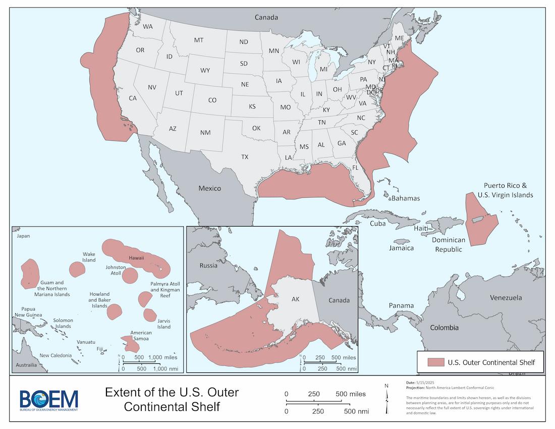
In the Outer Continental Shelf Lands Act, the term "Outer Continental Shelf" (OCS) is defined as "(1) all submerged lands lying seaward and outside of the area of lands beneath navigable waters as defined in the Submerged Lands Act, and of which the subsoil and seabed appertain to the United States and are subject to its jurisdiction and control or within the exclusive economic zone of the United States and adjacent to any territory of the United States; and (2) does not include any area conveyed by Congress to a territorial government for administration (43 USC 1331).
Not all of the OCS is subdivided into planning areas; the areas surrounding Hawaii and the U.S. Territories are distinct and manageable portions of the OCS that do not require a planning area designation for differentiation purposes.
Recent OCS Jurisdiction Changes
Extended Continental Shelf Changes
The portion of the continental shelf beyond 200 nautical miles from the coast is known as the “extended continental shelf,” or ECS. On December 21, 2023, the U.S. Department of State published a Federal Register notice announcing the outer limits of the continental shelf of the United States of America. See Public Notice 12244: Continental Shelf and Maritime Boundaries; Notice of Limits, 88 FR 88470. The United States has identified seven ECS offshore areas: the Arctic, Atlantic (East Coast), Bering Sea, Pacific (West Coast), Mariana Islands, and two areas in the Gulf of America. For additional information, see the U.S. Extended Continental Shelf Project, led by the Department of State, the Department of the Interior, and the National Oceanic and Atmospheric Administration.
Inflation Reduction Act Changes
The Inflation Reduction Act of 2022 (IRA; Pub. Law 117-169), amended the definition of the OCS in the OCS Lands Act to include submerged lands within the exclusive economic zone (EEZ) adjacent to all U.S. Territories.
The IRA also amended the OCS Lands Act by adding a definition of “State” to include each of the several 50 States of the Union, the Commonwealth of Puerto Rico, Guam, American Samoa, U.S. Virgin Islands, and the Commonwealth of the Northern Mariana Islands. Though the IRA specifically provides that areas offshore these territories are not available for oil and gas leasing, the expanded definition of the OCS makes territorial submerged lands available for offshore wind and minerals leasing.
State Jurisdiction
For most coastal states, the extent of their State Jurisdiction is three nautical miles (nm) from the coast line. Exceptions to this are Texas, the Gulf Coast of Florida, and the Commonwealth of Puerto Rico, where jurisdiction extends nine nm from shore. In some cases, the Submerged Lands Act (SLA) coast line can become fixed and static, i.e., when the U.S. Supreme Court fixes (immobilizes) an SLA boundary by judicial decree.
Federal Jurisdiction
Federal Jurisdiction is defined by Federal statute (e.g., the SLA) and under accepted rules of international law. Specifically, under international law, the continental shelf extends to the outer edge of the continental margin, or to 200 nm from the baseline, whichever is greater. Where the outer edge of the continental margin extends beyond 200 nm from the baseline, the outer limits of the continental shelf are determined in accordance with Article 76 of the 1982 United Nations Convention on the Law of the Sea. While the United States has not acceded to the Convention, the U.S. considers it to represent customary international law.
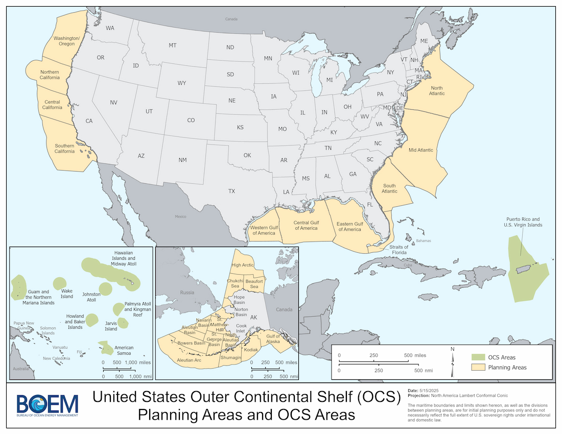
OCS Planning Areas and OCS Areas
OCS jurisdiction covers approximately 3.2 billion acres and includes:
- 27 planning areas covering approximately 1.68 billion acres
- 9 OCS Areas covering approximately 1.48 billion acres
The main purpose of an OCS planning area is to divide large OCS regions for planning purposes. Planning areas are also used to facilitate the required analytical comparison among the OCS regions at the National OCS Oil and Gas Leasing Program development stage, as well as coordination with state and local governments. The four OCS regions are Alaska, Pacific, Gulf of America, and Atlantic.
OCS Acreages
| Planning Area | Oil and Gas Leasing Program (millions of acres) | Renewable Energy and Marine Minerals Programs (millions of acres) |
|---|---|---|
| Alaska Planning Areas Totals | 1,047.17 | 1,047.17 |
| Aleutian Basin | 41.33 | 41.33 |
| Chukchi Sea | 62.59 | 62.59 |
| Beaufort Sea | 65.08 | 65.08 |
| Hope Basin | 12.82 | 12.82 |
| Navarin Basin | 34.02 | 34.02 |
| North Aleutian Basin | 32.45 | 32.45 |
| St. George Basin | 70.23 | 70.23 |
| Norton Basin | 24.25 | 24.25 |
| Cook Inlet | 5.36 | 5.36 |
| Gulf of Alaska | 95.11 | 95.11 |
| Shumagin | 69.01 | 69.01 |
| Kodiak | 67.99 | 67.99 |
| Aleutian Arc | 215.63 | 215.63 |
| Bowers Basin | 87.59 | 87.59 |
| St. Matthew-Hall | 54.57 | 54.57 |
| High Arctic | 109.14 | 109.14 |
| Pacific Planning Areas Totals | 204.47 | 204.47 |
| Washington/Oregon | 58.45 | 58.45 |
| Northern California | 42.30 | 42.30 |
| Central California | 35.59 | 35.59 |
| Southern California | 68.13 | 68.13 |
| Hawaiian Islands & Midway Atoll* OCS Area Totals | N/A | 609.12 |
| Pacific Territories OCS Areas Totals | N/A | 825.83 |
| American Samoa | N/A | 99.95 |
| Guam/CNMI | N/A | 238.83 |
| Howland and Baker Islands | N/A | 112.34 |
| Jarvis Island | N/A | 77.88 |
| Johnston Atoll | N/A | 109.34 |
| Palmyra Atoll and Kingman Reef | N/A | 86.85 |
| Wake Island | N/A | 100.64 |
| Gulf of America Planning Areas Totals | 159.36 | 159.36 |
| Western | 28.58 | 28.58 |
| Central | 66.45 | 66.45 |
| Eastern | 64.33 | 64.33 |
| Atlantic Planning Areas Totals | 273.63 | 273.63 |
| North Atlantic | 97.11 | 97.11 |
| Mid-Atlantic | 117.06 | 117.06 |
| South Atlantic | 49.82 | 49.82 |
| Straits of Florida | 9.64 | 9.64 |
| Puerto Rico, U.S. Virgin Islands, and Other Territories**OCS Area Totals | N/A | 49.63 |
| All OCS Totals | 1,684.63 | 3,169.21 |