
The Bureau of Ocean Energy Management (BOEM) and the Bureau of Safety and Environmental Enforcement (BSEE) have issued regulations addressing requirements of the National Historic Preservation Act (NHPA) for OCS leases at 30 CFR 550.194 and 30 CFR 250.194. BSEE also issued regulations addressing archaeological resources in the context of pipeline rights-of-way at 250.1007 and 250.1010. The implementing regulations of NHPA at 36 CFR §800.4 requires federal agencies to review existing information on historic properties within the area of potential effects, including any data concerning possible historic properties not yet identified, prior to approving an undertaking. The Secretary of Interior’s Guidelines and Standards for Archaeology and Historic Preservation encourages archival research first prior to undertaking survey to determine if significant resources could be affected by an undertaking.
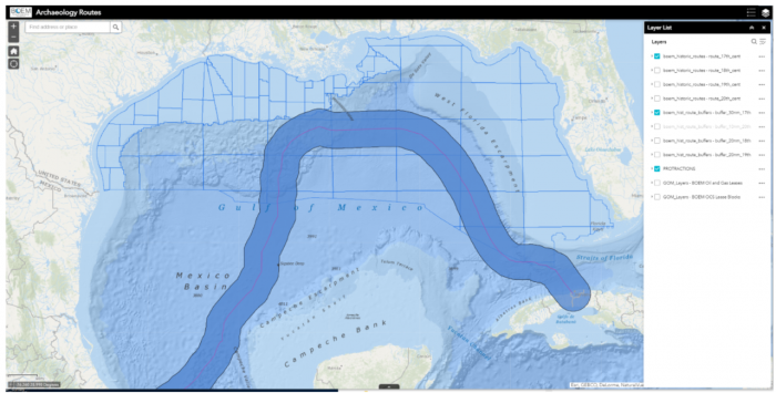
In order to provide the BOEM with information on what resources may be present on the seafloor of the Gulf of America, the subject matter expert team at BOEM examined where ships are reported to have sailed (i.e., vessel sailing logs and route maps), and therefore, where they were likely to have sunk, while also recognizing a known loss of accuracy that increases as one moves further back in time. In so doing, 46 historic maps were collected that contained sailing route information from the 16th through 20th centuries. Four hundred eleven routes were mapped in ArcGIS, of which 358 crossed into the Gulf of America Region protraction areas. This, of course, represents a small fraction of the thousands of ships that have plied these waters through history, but provides a fair perspective of where ships were traveling at various points in time.
The Archaeology Routes Application allows the user to view the geo-rectified courses of ships taken over the past 400 years. By selecting routes by century from the layer list and applying recommended buffers, the user can compare historic routes to the modern seascape to observe where shipwrecks may have occurred within BOEM lease areas. This geospatial representation shows an interpretation based on hand-drawn maps from a 400-year period. By making this available, we are not endorsing the quality of those data or the interpretations based on those data or making any claims that it can be used in lieu of a geophysical survey to determine the presence or absence of an archaeological resource. BOEM will not assume any responsibility or liability for damages caused by errors or omissions in the original data set or in the interpretations of those data. These data are not intended to be used in a submission seeking approval from BOEM or BSEE or any legal document, and they should not be used as such.