Contact: Marjorie Weisskohl (BOEM) 703-787-1304
Fred Gorell (NOAA) 301-802-8334
Rachel Pawlitz (USGS) 352-264-3554

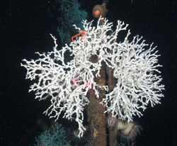
Two Lophelia coral colonies growing on a small metal portion of the subsea completion structure in block Mississippi Canyon 355 at a depth of about 1,500 ft. Red laser beams, projected from the ROV, represent a separation of 10 centimeters (about 4 inches). The red crab on top of the coral is called a squat lobster. Many others were also seen on this structure High Resolution (Lophelia II 2012 Expedition, NOAA-OER/BOEM)
A team of federal and university scientists on a 10-day expedition in the Gulf of Mexico has discovered Lophelia coral growing deeper than previously seen anywhere in the Gulf. Newly available information on Lophelia’s growth rate and conditions will inform future environmental review and decision-making for the protection of deep-water coral habitats.
The overall goal of the mission, which left Freeport, Texas, on July 14 and returned to Pensacola, Fla. on July 24, was to examine coral ecosystems and related habitats that developed over several decades on or near actively producing deep-ocean oil and gas production platforms. Undersea structures supporting energy production platforms provide some of the scarce hard surfaces in the Gulf where a deep cold-water coral that lives where there is no sunlight, can grow.
Scientists imaged corals in both high-definition video and still photography and also took samples for DNA sequencing to better understand the biology, growth and distribution of deep-sea corals. Through cameras on a remotely operated vehicle used to survey coral growth on oil and gas platforms, scientists observed Lophelia coral at a depth of 2620feet (799 m) on undersea structures supporting the Ram Powell platform, which was built in 1997 and is one of the deepest platforms in the Gulf. The previous record depth for Lophelia in the Gulf was about 2066 feet (630 m). Scientists also visited four other deepwater platforms.
“Finding Lophelia at this depth was very exciting for the whole team, especially for those of us who have been studying coral habitat for decades,” said Gregory Boland, a biological oceanographer in the Bureau of Ocean Energy Management’s (BOEM) Environmental Studies Program who has overseen this and other coral studies. “Our findings complement previous joint research on coral ecosystems and will help policy-makers manage and protect ocean resources on the Outer Continental Shelf.”

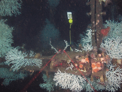
Coral community on top of a structure piling adjacent to a subsea oil and gas structure at a depth of about 1,500 ft. Red laser beams, projected from the ROV, represent a separation of 10 centimeters (about 4 inches). Lophelia coral colonies and anemones are abundant. The project team also placed a marker on top of the piling with a plastic ball of known dimensions for use as a size reference High Resolution(Lophelia II 2012 Expedition, NOAA-OER/BOEM.)
The expedition included scientists and technicians from BOEM, the National Oceanic and Atmospheric Administration (NOAA) Office of Ocean Exploration and Research, and the U.S. Geological Survey (USGS) operating jointly under the National Oceanographic Partnership Program, which fosters the use of pooled federal resources such as funding, ships, equipment, and personnel to best meet agency and national priorities in ocean stewardship. Scientists from Temple, Pennsylvania State and Florida State universities were an integral part of the team. For BOEM, the expedition was the culmination of a series of research missions taking place since 2002, when the bureau launched its first deepwater Lophelia coral studies in the Gulf. The new data will be incorporated into a final report BOEM plans to publish in 2013. The bureau plans to monitor deepwater corals periodically through other studies it will undertake in the region.
In the last 12 years, BOEM completed 13 studies of platform corals, fish and habitat; six platform biology studies are ongoing.
For BOEM, the expedition was the culmination of a series of research missions taking place since 2002, when the bureau launched its first deepwater coral studies in the Gulf. The new data will be incorporated into a final report BOEM plans to publish in 2013. The bureau plans to monitor deepwater corals periodically through other studies it will undertake in the region.
The cruise augments the ongoing USGS program Diversity Systematics and Connectivity of Vulnerable Reef Ecosystems (DISCOVRE), dedicated to the study of deep-sea coral environments in the Gulf and the Atlantic.

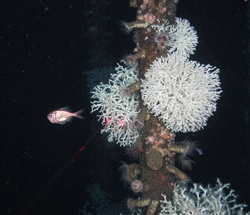
Large Lophelia colonies and numerous anemones on a portion of the subsea completion structure in block Mississippi Canyon 355 at a depth of about 1,500 ft. A western roughy is seen to the left of the structure. The structure was installed on the seabed in 1992 allowing a maximum possible period of 20 years for coral growth High Resolution(Lophelia II 2012 Expedition, NOAA-OER/BOEM.) NOAA-OER/BOEM.
Joint ocean expeditions and discoveries also raise questions that give rise to follow-on research and advanced technology development, and they provide critical information to help ocean resource managers make better-informed decisions.
Photos, videos and logs from the expedition are posted on NOAA’s ocean exploration website under the heading of “Lophelia II 2012: Deepwater Platform Corals” at
http://oceanexplorer.noaa.gov/. Data from the mission advance NOAA’s goals of exploring the ocean for the purpose of discovery and the advancement of knowledge.
BOEM manages the exploration and development of the nation's offshore energy and mineral resources. The Bureau seeks to balance economic development, energy production, and environmental protection through oil and gas leasing, renewable energy development and environmental reviews and studies.
More information about BOEM’s Environmental Studies Program is available at: http:www.boem.gov/studies/
NOAA’s mission is to understand and predict changes in the Earth's environment, from the depths of the ocean to the surface of the sun, and to conserve and manage our coastal and marine resources.
Join NOAA on Facebook, Twitter and its other social media channels. More information about NOAA is available at: http://www.noaa.gov.
The USGS serves the Nation by providing reliable scientific information to describe and understand the Earth; minimize loss of life and property from natural disasters; manage water, biological, energy, and mineral resources; and enhance and protect our quality of life.
More information about USGS is available at: http:www.usgs.gov.