
The Mapping & Boundary Branch performs mathematical offshore boundary location computations and prepares Official Protraction Diagrams (OPDs), and Supplemental Official OCS Block Diagrams (SOBDs) depicting OCS Block information, the Submerged Lands Act Boundary (aka - State Seaward Boundary), Limit of "8(g) Zone", the Continental Shelf Boundary (CSB) which marks the limit of U.S. jurisdiction for offshore mineral development, and corresponding area measurements. The analytical procedures employed and the computer programs utilized to perform various offshore boundary geometric computations are described in OCS Report MMS 99-0006.
OPD Images
A standard Official Protraction Diagrams (OPD) is 1 degree in latitude by 2 degrees in longitude (at lower latitudes: 0 - 48 degrees). At higher latitudes (48 - 75 degrees) such as Alaska and northern Washington, OPDs are 3 degrees wide. OPD limits usually approximate the standard 1:250,000 scale U.S. Geological Survey topographic map series. The OPDs are numbered using the United Nations International Map of the World Numbering System. OPD names usually coincide with standard topographic sheet names when diagrams include land areas. OPD sheet names relate to land features, or to hydrographic features contained within the limits of the diagram. Shoreline planimetric detail is shown when it falls within the limits of a diagram. Older OPDs were prepared on mylar with manual cartographic methods and then scanned into Adobe .pdf files. Newer OPDs were prepared electronically and converted to Adobe .pdf files.
NOTE: Atlantic OPDs that show the Submerged Lands Act and Section 8(g) Zone boundaries do not reflect post-2010 shoreline changes.
SOBD Images
A Supplemental Official OCS Block Diagram (SOBD) is prepared for each block intersected by an offshore boundary (Submerged Lands Act Boundary, Limit of "8(g) Zone", National Marine Sanctuaries, etc.). Note that not all OPDs contain such boundaries; therefore not all OPDs have SOBDs associated with them. The zip files offered here contains only current NAD 83 SOBDS. The historic (outdated) SOBDs can be obtained by contacting the Mapping & Boundary Branch. All future activities will be based on the most current SOBDs.
NOTE: Atlantic SOBDs do not reflect post-2010 shoreline changes.
Image File Formats
The most current approved revision for each Atlantic Region OPD and SOBD may be viewed and downloaded from the list below. OPDs are offered in Adobe (.pdf) format. SOBDs are available as Adobe (.pdf) files that have been compressed with WINZIP.
Individual Atlantic Region OPDs | ||
OPD Name | OPD Files | SOBD Files |
| Atlantic OPD Index: ATL_Index.PDF (Updated 11/30/17) | Atlantic OPDs PDF File Bundle ATL_OPD.zip Metadata | Atlantic SOBD PDF File Bundle ATL_SOBD.zip Metadata |
| Puerto Rico & Virgin Islands: PRVI OPD Index 2017.pdf (Updated 12/4/2017) | Puerto Rico & Virgin Islands OPDs PDF File Bundle PRVI_OPD.zip Metadata | Puerto Rico & Virgin Islands SOBD PDF File Bundle PRVI_SOBD.zip Metadata |
| ND19-02 Venezuelan Basin | Not Yet Published | Not Yet Published |
| ND19-03 Columbian Basin | Not Yet Published | Not Yet Published |
| ND19-06 Venezuelan Plain | Not Yet Published | Not Yet Published |
| ND20-01 Aves Apron | Not Yet Published | Not Yet Published |
| NE19-02 Unnamed | Not Yet Published | Not Yet Published |
| NE19-03 Mona Ridge | Not Yet Published | Not Yet Published |
| NE19-05 Santa Domingo | Not Yet Published | Not Yet Published |
| NE19-06 San Juan | Not Yet Published | Not Yet Published |
| NE19-08 Unnamed | Not Yet Published | Not Yet Published |
| NE19-09 Desecheo Basin | Not Yet Published | Not Yet Published |
| NE19-11 Unnamed | Not Yet Published | Not Yet Published |
| NE19-12 Unnamed | Not Yet Published | Not Yet Published |
| NE20-01 Anegada Canyon | Not Yet Published | Not Yet Published |
| NE20-04 St. Thomas | Provisional - Unpublished | NE20-04.zip Provisional - Unpublished |
| NE20-05 Anguila | Not Yet Published | Not Yet Published |
| NE20-07 St. Croix | NE20-07-05-MAR-2003.pdf Provisional - Unpublished | NE20-07.zip Provisional - Unpublished |
| NE20-08 St. Kitts-Nevis | Not Yet Published | Not Yet Published |
| NE20-10 Unnamed | Not Yet Published | Not Yet Published |
| NE20-11 Basse-Terre Valley | Not Yet Published | Not Yet Published |
| NF17-01 Tortugas Valley | NF17-01-13-MAR-1997.pdf Approved 13-MAR-1997 | NF17-01.zip |
| NF17-02 Rompidas Ledge | NF17-02-13-MAR-1997.pdf Approved 13-MAR-1997 | NF17-02.zip |
| NF19-09 Unnamed | Not Yet Published | Not Yet Published |
| NF19-11 Unnamed | Not Yet Published | Not Yet Published |
| NF19-12 Dos Ninos Knoll | Not Yet Published | Not Yet Published |
| NF20-07 Puerto Rico Ridge | Not Yet Published | Not Yet Published |
| NF20-10 Puerto Rico Trench | Not Yet Published | Not Yet Published |
| NG17-02 Ft. Pierce | NG17-02-01-APR-2008.pdf Approved 01-APR-2008 | NG17-02.zip |
| NG17-03 Walker Cay | NG17-03-01-APR-2008.pdf Approved 01-APR-2008 | NG17-03.zip (updated 09/02/10) |
| NG17-05 West Palm Beach | NG17-05-01-APR-2008.pdf Approved 01-APR-2008 | NG17-05.zip (updated 09/02/10) |
| NG17-06 Bahamas | NG17-06-01-APR-2008.pdf Approved 01-APR-2008 | NG17-06.zip (updated 09/02/10) |
| NG17-08 Miami | NG17-08-01-APR-2008.pdf Approved 01-APR-2008 | NG17-08.zip (updated 09/02/10) |
| NG17-09 Bimini | NG17-09-01-APR-2008.pdf Approved 01-APR-2008 | NG17-09.zip (updated 09/02/10) |
| NG17-10 Dry Tortugas | NG17-10-01-APR-2008.pdf Approved 01-APR-2008 | NG17-10.zip (updated 09/02/10) |
| NG17-11 Key West | NG17-11-01-APR-2008.pdf Approved 01-APR-2008 | NG17-11.zip (updated 09/02/10) |
| NG17-12 Andros | NG17-12-13-MAR-1997.pdf Approved 13-MAR-1997 | NG17-12.zip |
| NH17-02 Brunswick | NH17-02-01-APR-2008.pdf Approved 01-APR-2008 | NH17-02.zip (updated 09/02/10) |
| NH17-03 Hoyt Hills | NH17-03-23-AUG-1996.pdf Approved 23-AUG-1996 | NH17-03.zip |
| NH17-05 Jacksonville | NH17-05-01-APR-2008.pdf Approved 01-APR-2008 | NH17-05.zip (updated 09/02/10) |
| NH17-06 Stetson Mesa | NH17-06-23-AUG-1996.pdf Approved 23-AUG-1996 | |
| NH17-08 Daytona Beach | NH17-08-01-APR-2008.pdf Approved 01-APR-2008 | NH17-08.zip (updated 09/02/10) |
| NH17-09 Adams | NH17-09-23-AUG-1996.pdf Approved 23-AUG-1996 | |
| NH17-11 Orlando | NH17-11-01-APR-2008.pdf Approved 01-APR-2008 | NH17-11.zip (updated 09/02/10) |
| NH17-12 Pillsbury | NH17-12-13-MAR-1997.pdf Approved 13-MAR-1997 | NH17-12.zip |
| NH18-01 Harrington Hill | NH18-01-01-APR-2008.pdf Approved 01-APR-2008 | |
| NH18-02 Taylor | NH18-02-01-APR-2008.pdf Approved 01-APR-2008 | |
| NH18-03 (Unnamed) | NH18-03-01-APR-2008.pdf Approved 01-APR-2008 | |
| NH18-04 Blake Spur | NH18-04-01-APR-2008.pdf Approved 01-APR-2008 | |
| NH18-05 (Unnamed) | NH18-05-01-APR-2008.pdf Approved 01-APR-2008 | |
| NH18-07 Mc Alinden Spur | NH18-07-23-AUG-1996.pdf Approved 23-AUG-1996 | |
| NH18-10 Blake Escarpment | NH18-10-13-MAR-1997.pdf Approved 13-MAR-1997 | NH18-10.zip |
| NI17-09 Georgetown | NI17-09-01-APR-2008.pdf (updated 09/02/10) | |
| NI17-11 Savannah | NI17-11-01-APR-2008.pdf Approved 01-APR-2008 | NI17-11.zip (updated 09/02/10) |
| NI17-12 James Island | NI17-12-01-APR-2008.pdf Approved 01-APR-2008 | NI17-12.zip (updated 09/02/10) |
| NI18-01 Rocky Mount | NI18-01-01-APR-2008.pdf Approved 01-APR-2008 | NI18-01.zip (updated 09/02/10) |
| NI18-02 Manteo | NI18-02-01-APR-2008.pdf Approved 01-APR-2008 | NI18-02.zip (17,019 KB) (updated 09/02/10) |
| NI18-03 Wraight | NI18-03-23-AUG-1996.pdf Approved 23-AUG-1996 | |
| NI18-04 Beaufort | NI18-04-01-APR-2008.pdf Approved 01-APR-2008 | NI18-04.zip (updated 09/02/10) |
| NI18-05 Russell | NI18-05-01-APR-2008.pdf Approved 01-APR-2008 | NI18-05.zip (updated 09/02/10) |
| NI18-06 Hatteras Ridge | NI18-06-01-APR-2008.pdf Approved 01-APR-2008 | |
| NI18-07 Cape Fear | NI18-07-01-APR-2008.pdf Approved 01-APR-2008 | NI18-07.zip (updated 09/02/10) |
| NI18-08 Marmer | NI18-08-01-APR-2008.pdf Approved 01-APR-2008 | |
| NI18-09 Lanier | NI18-09-01-APR-2008.pdf Approved 01-APR-2008 | |
| NI18-10 Richardson Hills | NI18-10-01-APR-2008.pdf Approved 01-APR-2008 | |
| NI18-11 Wittman | NI18-11-01-APR-2008.pdf Approved 01-APR-2008 | |
| NI18-12 Tibbet | NI18-12-01-APR-2008.pdf Approved 01-APR-2008 | |
| NI19-01 Lippold | NI19-01-23-AUG-1996.pdf Approved 23-AUG-1996 | |
| NI19-04 Evans | NI19-04-01-APR-2008.pdf Approved 01-APR-2008 | |
| NI19-07 (Unnamed) | NI19-07-01-APR-2008.pdf Approved 01-APR-2008 | |
| NJ18-02 Wilmington | NJ18-02-01-MAY-2006.pdf Approved 01-MAY-2006 | NJ18-02.zip (updated 09/02/10) |
| NJ18-03 Hudson Canyon | NJ18-03-01-APR-2008.pdf Approved 01-APR-2008 | |
| NJ18-05 Salisbury | NJ18-05-01-NOV-2016.pdf Approved 01-Nov-2016 | NJ18-05.zip (updated 03/03/17) |
| NJ18-06 Wilmington Canyon | NJ18-06-01-APR-2008.pdf Approved 01-APR-2008 | |
| NJ18-08 Chincoteague | NJ18-08-01-MAY-2006.pdf Approved 01-MAY-2006 | NJ18-08.zip (updated 09/02/10) |
| NJ18-09 Baltimore Rise | NJ18-09-01-APR-2008.pdf Approved 01-APR-2008 | |
| NJ18-11 Currituck Sound | NJ18-11-01-NOV-2016.pdf Approved 01-Nov-2016 | NJ18-11.zip (updated 03/03/17) |
| NJ18-12 Hyman | NJ18-12-23-AUG-1996.pdf Approved 23-AUG-1996 | |
| NJ19-01 Block Canyon | NJ19-01-01-APR-2008.pdf Approved 01-APR-2008 | |
| NJ19-02 Veatch Canyon | NJ19-02-23-AUG-1996.pdf Approved 23-AUG-1996 | |
| NJ19-03 Bear Seamount | NJ19-03-23-AUG-1996.pdf Approved 23-AUG-1996 | |
| NJ19-04 Heezen Plateau | NJ19-04-01-APR-2008.pdf Approved 01-APR-2008 | |
| NJ19-05 Powell | NJ19-05-01-APR-2008.pdf Approved 01-APR-2008 | |
| NJ19-06 Muller | NJ19-06-01-APR-2008.pdf Approved 01-APR-2008 | |
| NJ19-07 Jones | NJ19-07-01-APR-2008.pdf Approved 01-APR-2008 | |
| NJ19-08 Uchupi | NJ19-08-01-APR-2008.pdf Approved 01-APR-2008 | |
| NJ19-10 Wilmington Valley | NJ19-10-01-APR-2008.pdf Approved 01-APR-2008 | |
| NJ20-01 Balanus Seamount | NJ20-01-23-AUG-1996.pdf Approved 23-AUG-1996 | |
| NK18-09 Hartford | NK18-09-01-MAY-2006.pdf Approved 01-MAY-2006 | NK18-09.zip (updated 09/02/10) |
| NK18-11 Newark | NK18-11-01-MAY-2006.pdf Approved 01-MAY-2006 | NK18-11.zip (updated 09/02/10) |
| NK18-12 New York | NK18-12-01-MAY-2006.pdf Approved 01-MAY-2006 | NK18-12.zip (updated 09/02/10) |
| NK19-01 Portland | NK19-01-01-MAY-2006.pdf Approved 01-MAY-2006 | NK19-01.zip (updated 09/02/10) |
| NK19-02 Bath | NK19-02-01-MAY-2006.pdf Approved 01-MAY-2006 | NK19-02.zip (updated 09/02/10) |
| NK19-03 Jordan Basin | NK19-03-13-MAR-1997.pdf Approved 13-MAR-1997 | NK19-03.zip |
| NK19-04 Boston | NK19-04-19-JAN-2005.pdf Approved 19-JAN-2005 | NK19-04.zip (updated 09/09/10) |
| NK19-05 Cashes Ledge | NK19-05-19-JAN-2005.pdf Approved 19-JAN-2005 | NK19-05.zip (updated 09/09/10) |
| NK19-06 Browns Bank | NK19-06-13-MAR-1997.pdf Approved 13-MAR-1997 | NK19-06.zip |
| NK19-07 Providence | NK19-07-01-MAY-2006.pdf Approved 01-MAY-2006 | NK19-07.zip (11,190 KB) (updated 09/02/10) |
| NK19-08 Chatham | NK19-08-19-JAN-2005.pdf Approved 19-JAN-2005 | NK19-08.zip (updated 09/09/10) |
| NK19-09 Corsair Canyon | NK19-09-13-MAR-1997.pdf Approved 13-MAR-1997 | NK19-09.zip |
| NK19-10 Block Island Shelf | NK19-10-01-MAY-2006.pdf Approved 01-MAY-2006 | NK19-10.zip (updated 09/02/10) |
| NK19-11 Hydrographer Canyon | NK19-11-23-AUG-1996.pdf Approved 23-AUG-1996 | |
| NK19-12 Lydonia Canyon | NK19-12-13-MAR-1997.pdf Approved 13-MAR-1997 | NK19-12.zip |
| NK20-10 Stewart | NK20-10-13-MAR-1997.pdf Approved 13-MAR-1997 | NK20-10.zip |
| NL19-11 Bangor | NL19-11-01-MAY-2006.pdf Approved 01-MAY-2006 | NL19-11.zip (updated 09/02/10) |
| NL19-12 Eastport | NL19-12-01-MAY-2006.pdf Approved 01-MAY-2006 | NL19-12.zip (updated 09/02/10) |
GIS Files
The various boundaries are also offered as ESRI ArcGIS shapefiles. Shapefiles can be viewed with the free ArcGIS Explorer viewer, ArcGIS, or a variety of other GIS systems. The shapefiles have been zipped using WinZip.
Note: The precise coordinates of a GIS file can be altered slightly by various GIS functions. For that reason, these GIS files are not an Official Record for BOEM offshore boundaries. Only the coordinates shown on Official OPDs, and SOBDs constitute an Official Record for offshore coordinate values.
| File Description | Zipped Download | Metadata Link | Graphic |
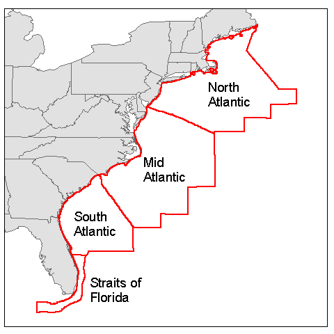
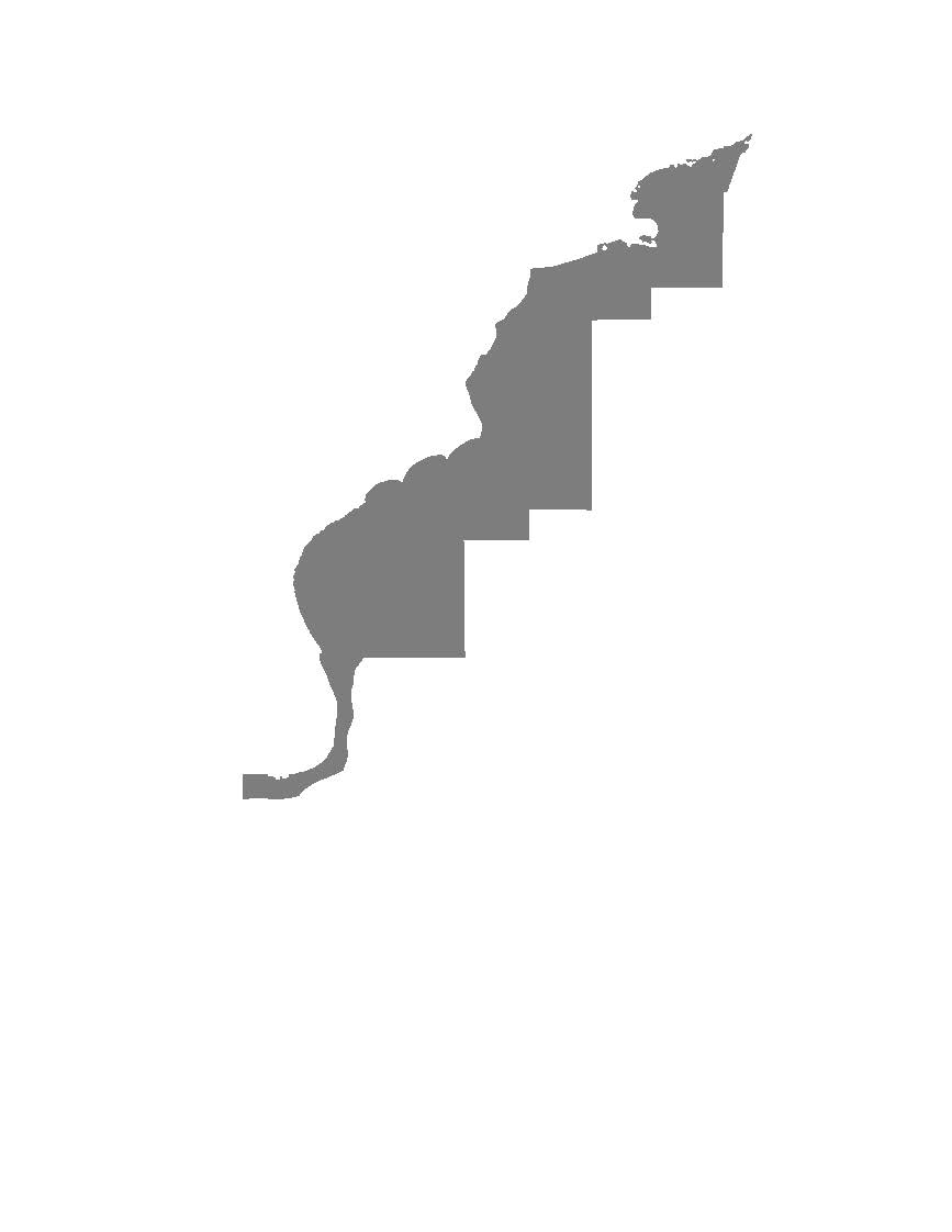
| Atlantic Planning Area outlines. | Updated (10/12/10) | metadata | Browse-Graphic |
| Standard OCS Blocks clipped to the Submerged Lands Act (SLA) boundary on the shoreward side(2304 hectares per standard block). | ATL_BLKCLIP.zip Updated (05/18/2017) | metadata | Browse-Graphic |
| OCS Block 1/16 Aliquot Parts (144 hectares per standard block) | ATL_ALIQUOTS.zip Updated (11/2/2012) | metadata | Browse-Graphic |
| Official Protraction Diagram (OPD) outlines. | ATL-PROTLMT.zip Updated (05/18/2017) | metadata | Browse-Graphic |
| Official Protraction Diagram (OPD) outlines clipped to the Submerged Lands Act (SLA) Boundary. | ATL-PROTCLP.zip Updated (05/18/2017) | metadata | Browse-Graphic |
| The SLA line marks Federal vs. State jurisdiction for Submerged Lands Act purposes. | ATL-SLA.zip Updated (05/18/2017) | metadata | Browse-Graphic |
| Limit of '8(g)' zone lies 3 nautical miles seaward of the SLA Boundary. See detailed metadata. | ATL-8G.zip Updated (05/18/2017) | metadata | Browse-Graphic |
| BSEE Oil and Gas Wells | BSEE_Atlantic_Wells.zip Updated (03/22/16) | metadata | No graphic |
| The coast line point file used (along with the coast line tangent file) to project the boundaries shown on existing/published OPDs. | ATL-BSLN-PT.zip Updated (10/12/10) | metadata | Browse-Graphic |
| Tangents (primarily Bay Closing Lines) used along with coast line points to project the boundaries on existing/published OPDs | ATL-BSLN-TN.zip Updated (10/12/10) | metadata | Browse-Graphic |
| Continental Shelf Boundary (CSB) marks the limit of U.S. jurisdiction for offshore mineral development. | ATL-CSB.zip Updated (10/12/10) | metadata | Browse-Graphic |
| BOEM 2019-2024 Draft Proposed Program Area - Atlantic Region | atl_5yr_2019_2024.zip | metadata | |
| BOEM 2019-2024 DPP Exclusion Option Areas – Atlantic Region | atl_5yr_2019_2024_excl_opt.zip | metadata |