
What's New?
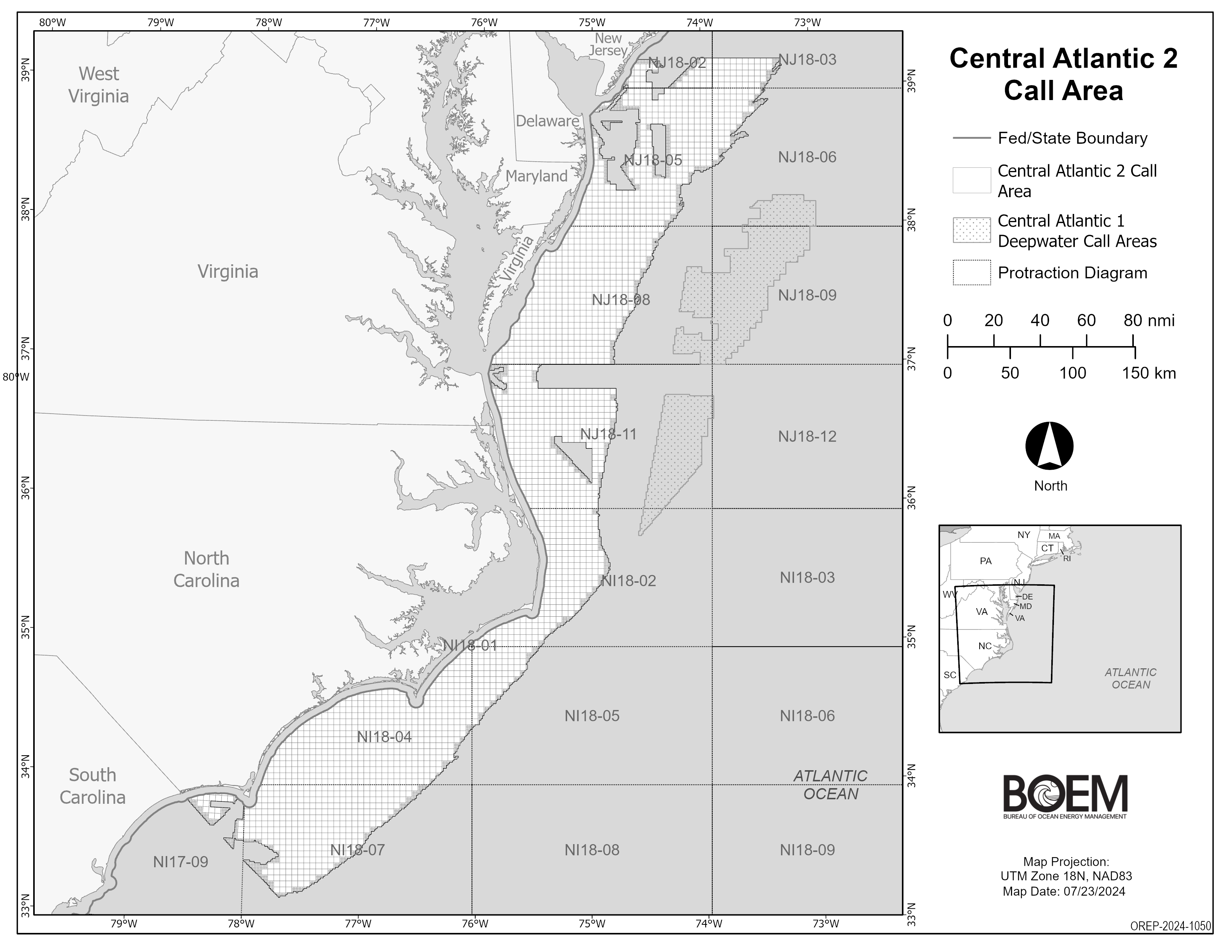
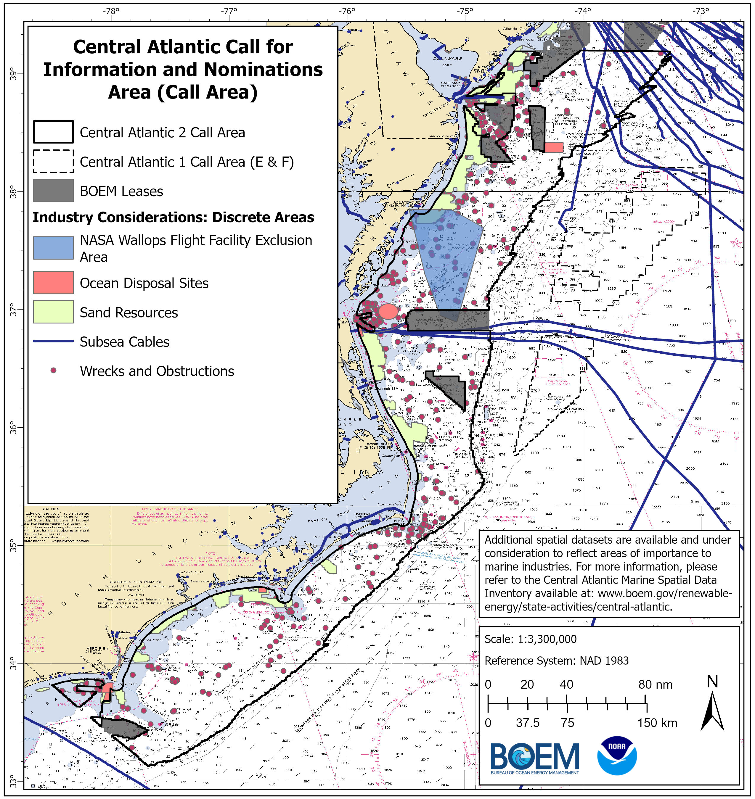
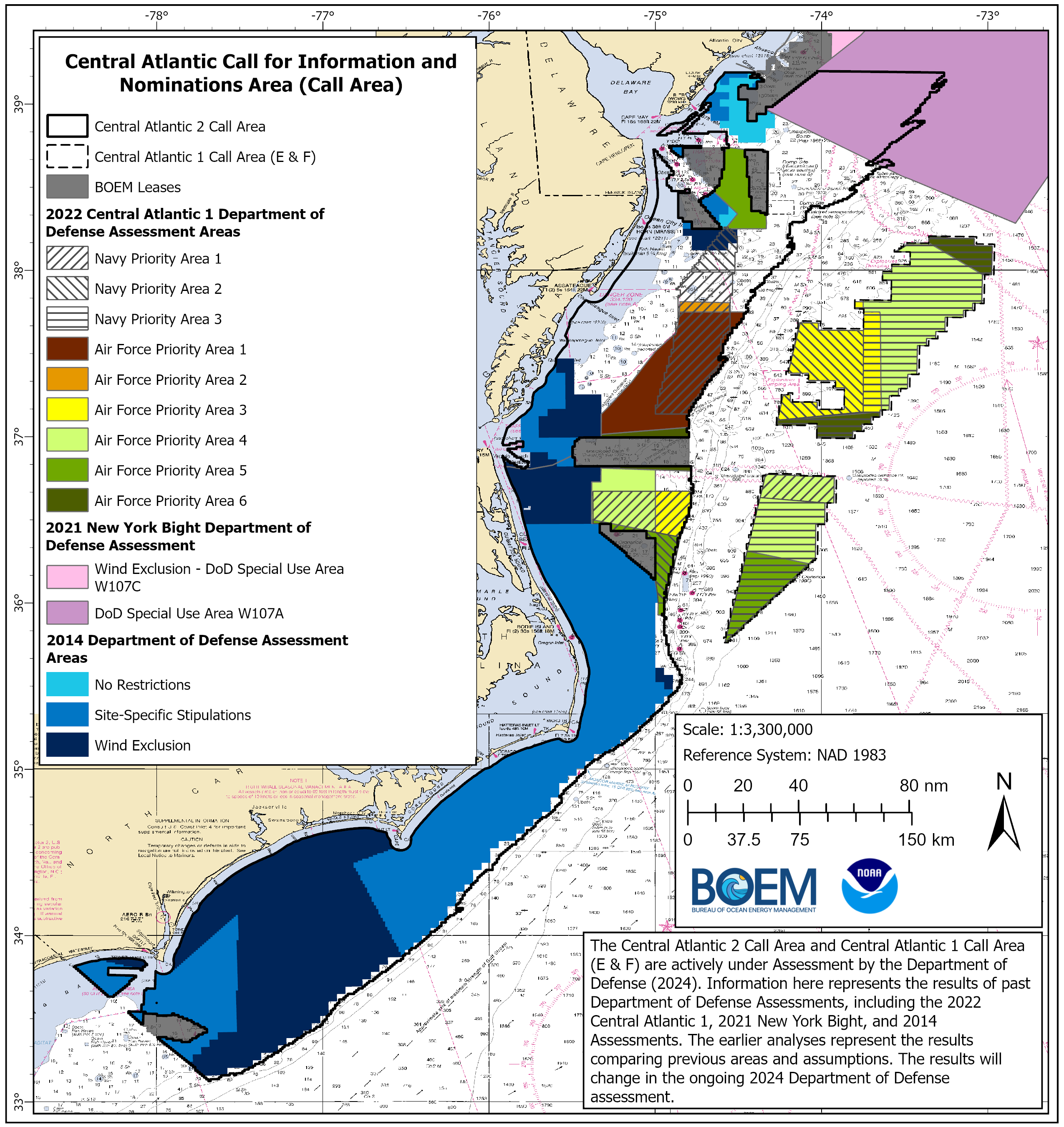
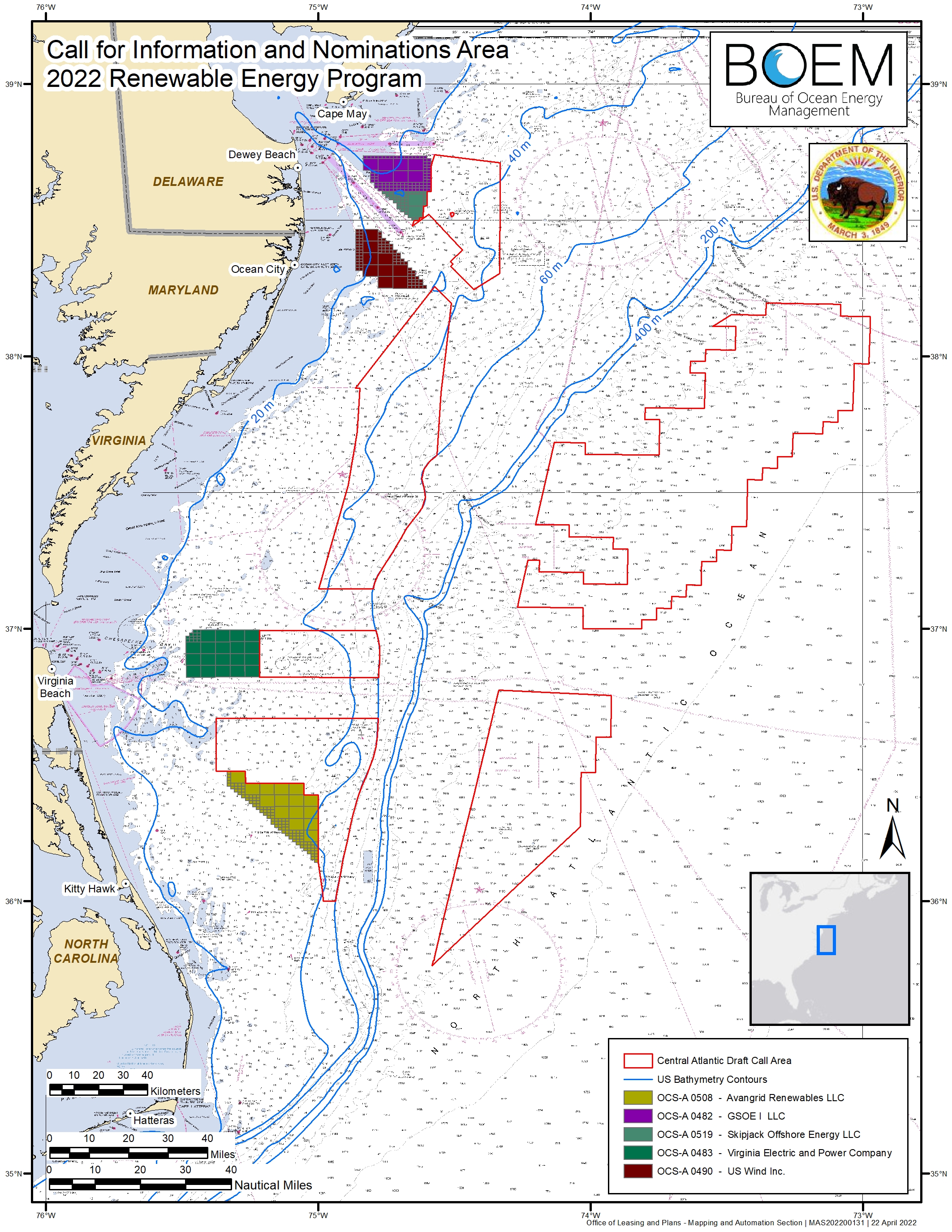
On August 21, 2024, BOEM announced that it would publish a Call for Information and Nominations for a second offshore wind sale in the Central Atlantic. This Central Atlantic Call Area is more than 13 million acres located off the coasts of New Jersey, Delaware, Maryland, Virginia and North Carolina.
The Call for Information published in the Federal Register on August 22 and initiated a 60-day comment period that ended on October 21, 2024. During the comment period, BOEM hosted several virtual and in-person public meetings in September and October 2024. For more information, visit the Central Atlantic 2 Call Public Meeting page.
BOEM anticipates this second offshore wind sale in the Central Atlantic will build upon the input and planning that led to the recent first Central Atlantic lease sale on August 14, 2024.
Below are documents related to the Call:
- Central Atlantic 2 Call for Information & Nominations
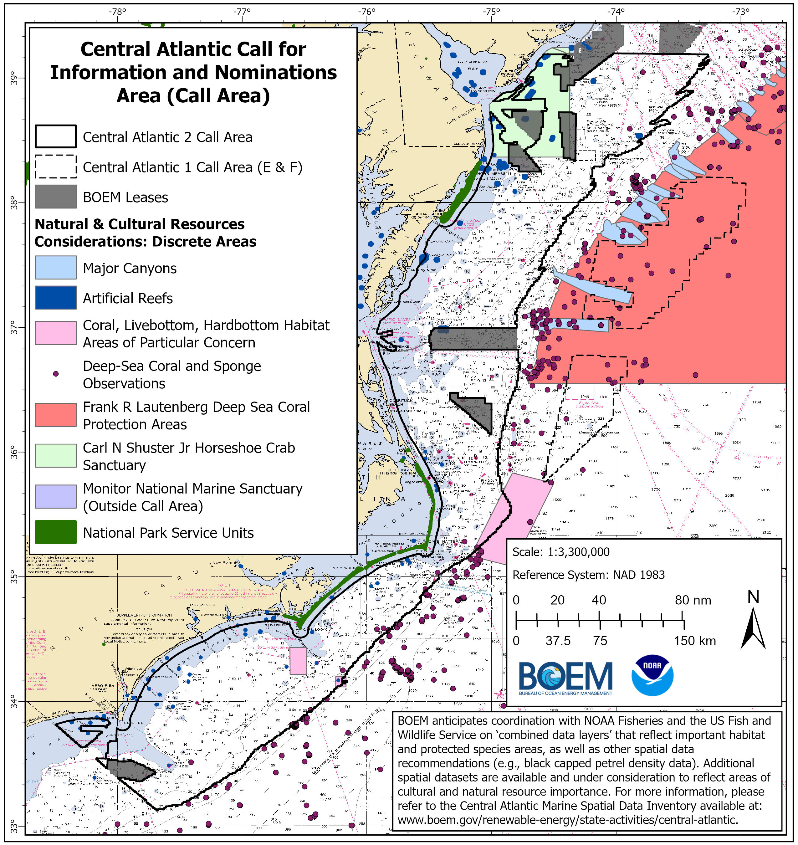
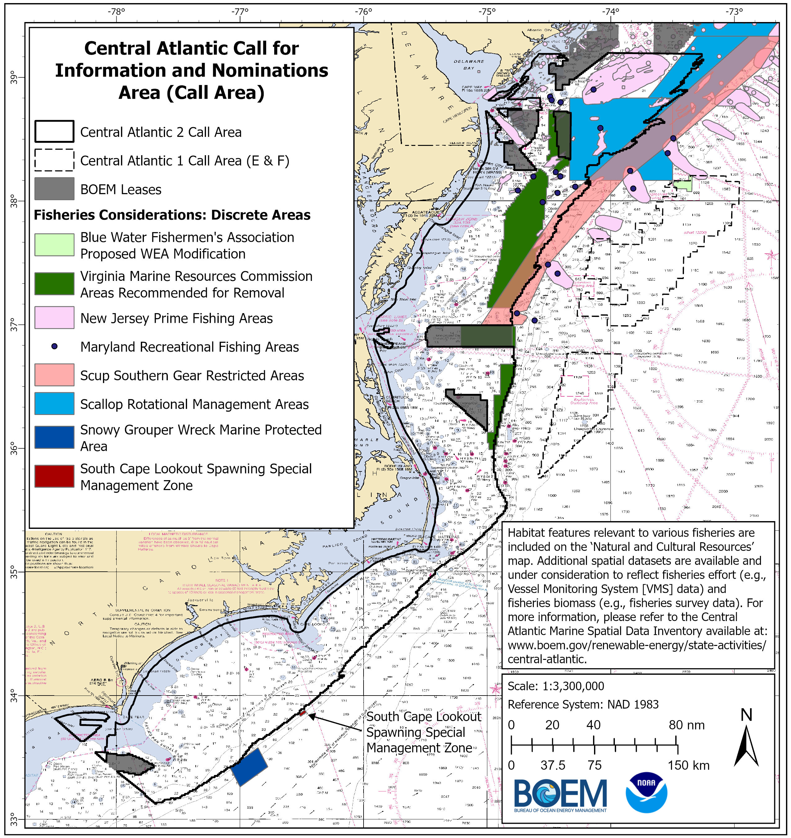
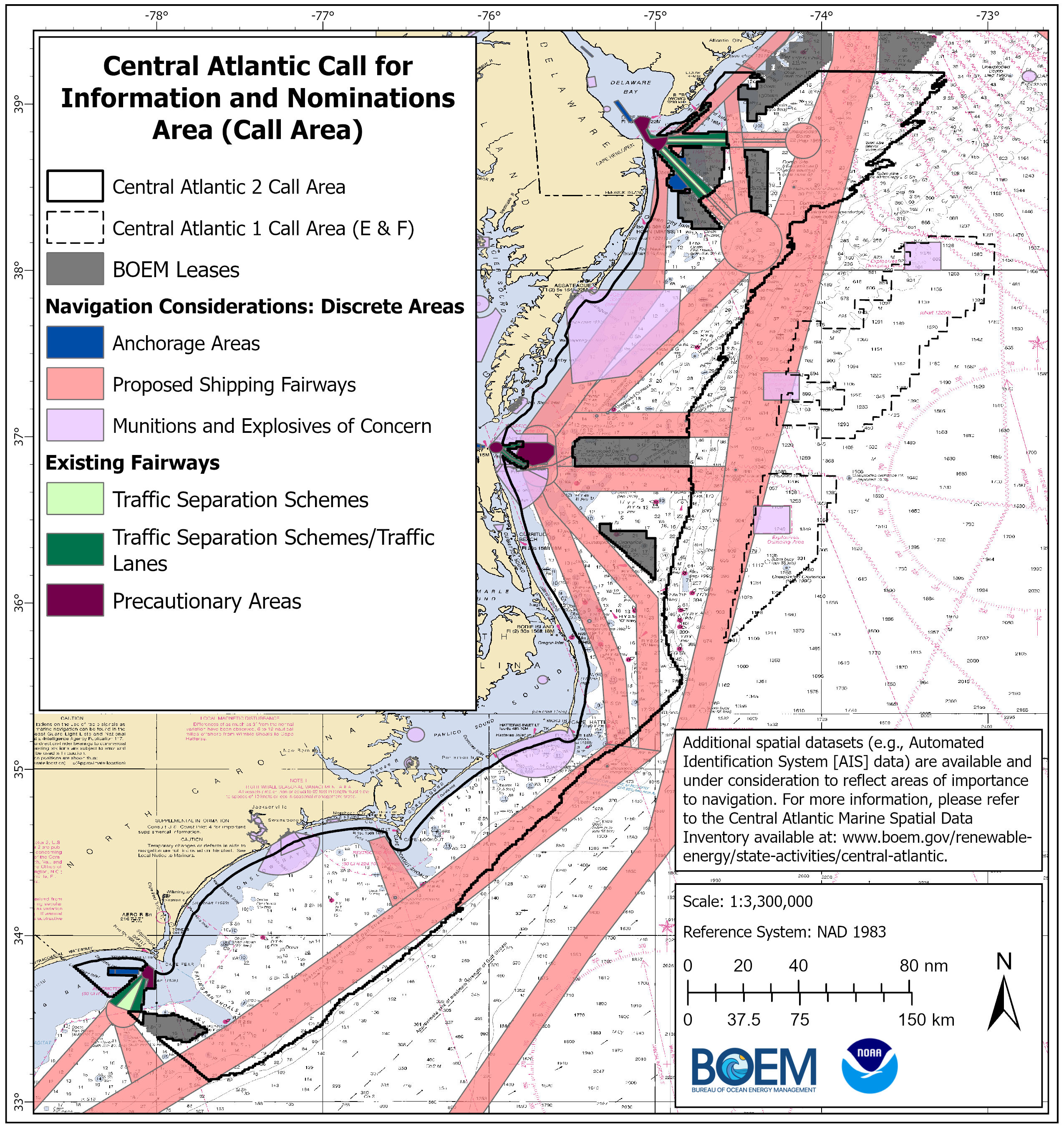
- Call Area – Maps of Use and Resource Considerations
- Central Atlantic 2: Data Layers Under Consideration for Draft Wind Energy Area Suitability Modeling
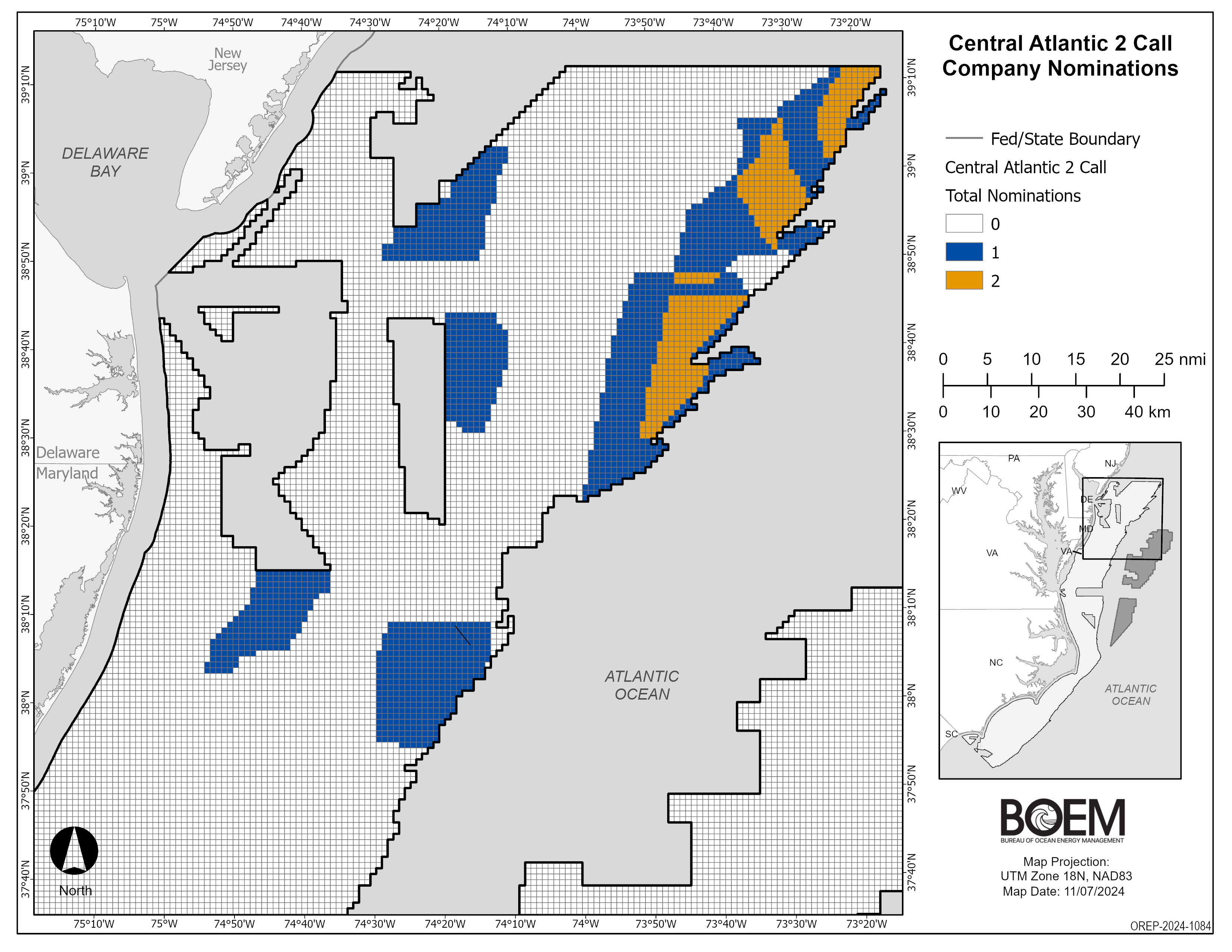
BOEM is currently reviewing and analyzing commercial nominations and public comments submitted in response to the Call. During the Call comment period, BOEM received nominations of areas of interest from 2 developers. Each of the parties listed below has been legally, technically, and financially qualified.
- Map of all Nominations Received
- Avangrid Renewables, LLC
- Corio USA Projectco LLC
First Offshore Wind Energy Lease Sale
On August 14, 2024, BOEM held an offshore wind energy lease sale for two areas on the OCS off the Central Atlantic. The auction netted a total of $92,651,501 in high bids.
See the Existing Leases tab for more information.
Public Engagement
BOEM coordinates Outer Continental Shelf renewable energy activities in the Central Atlantic with its Tribal, Federal, state, and local government partners through an intergovernmental renewable energy task force. BOEM also meets with ocean users and key stakeholders to gather information to inform decisions with regard to potential offshore wind activities.
- Central Atlantic 2 Call Public Meetings (September - October 2024)
- Central Atlantic Task Force Meeting (September 2024)
- Central Atlantic Proposed Lease Sale Public Auction Seminar (January 2024)
- Tribal and Renewable Energy Task Force Meetings (December 2021 – October 2023)
- Ocean User and Stakeholder Meetings (December 2021 – December 2022)
Related Press Releases
- BOEM Begins Process for Second Central Atlantic Offshore Wind Sale (08/21/2024)
- Biden-Harris Administration’s Central Atlantic Offshore Wind Lease Sale Yields Nearly $93 Million (08/14/2024)
- Biden-Harris Administration Announces Offshore Wind Lease Sale in Central Atlantic (06/28/2024)
- Biden-Harris Administration Leaders Announce Steps to Advance Offshore Wind Progress in Maryland (06/07/24)
- BOEM Finalizes Environmental Review of Potential Offshore Wind Lease Activities in the Central Atlantic (06/06/2024)
- You’re Invited: Central Atlantic Proposed Lease Sale Public Auction Seminar (01/09/2024)
- Biden Harris Administration Advances Offshore Wind in the Central Atlantic (12/11/2023)
- Interior Department Proposes Offshore Wind Sale in the Central Atlantic (12/11/2023)
- Central Atlantic Renewable Energy Task Force Meeting (09/29/2023)
- BOEM Finalizes Wind Energy Areas in the Central Atlantic (07/31/2023)
- BOEM Identifies Draft Wind Energy Areas in the Central Atlantic for Public Review and Comment (11/16/2022)
- BOEM Enhances its Processes to Identify Future Offshore Wind Energy Areas (09/16/2022)
- Biden-Harris Administration Advances Offshore Wind Energy Leasing on Atlantic and Pacific Coasts (04/27/2022)
On August 14, 2024, BOEM held an offshore wind energy lease sale for two areas on the Outer Continental Shelf (OCS) off the Central Atlantic. The auction netted a total of $92,651,501 in high bids.
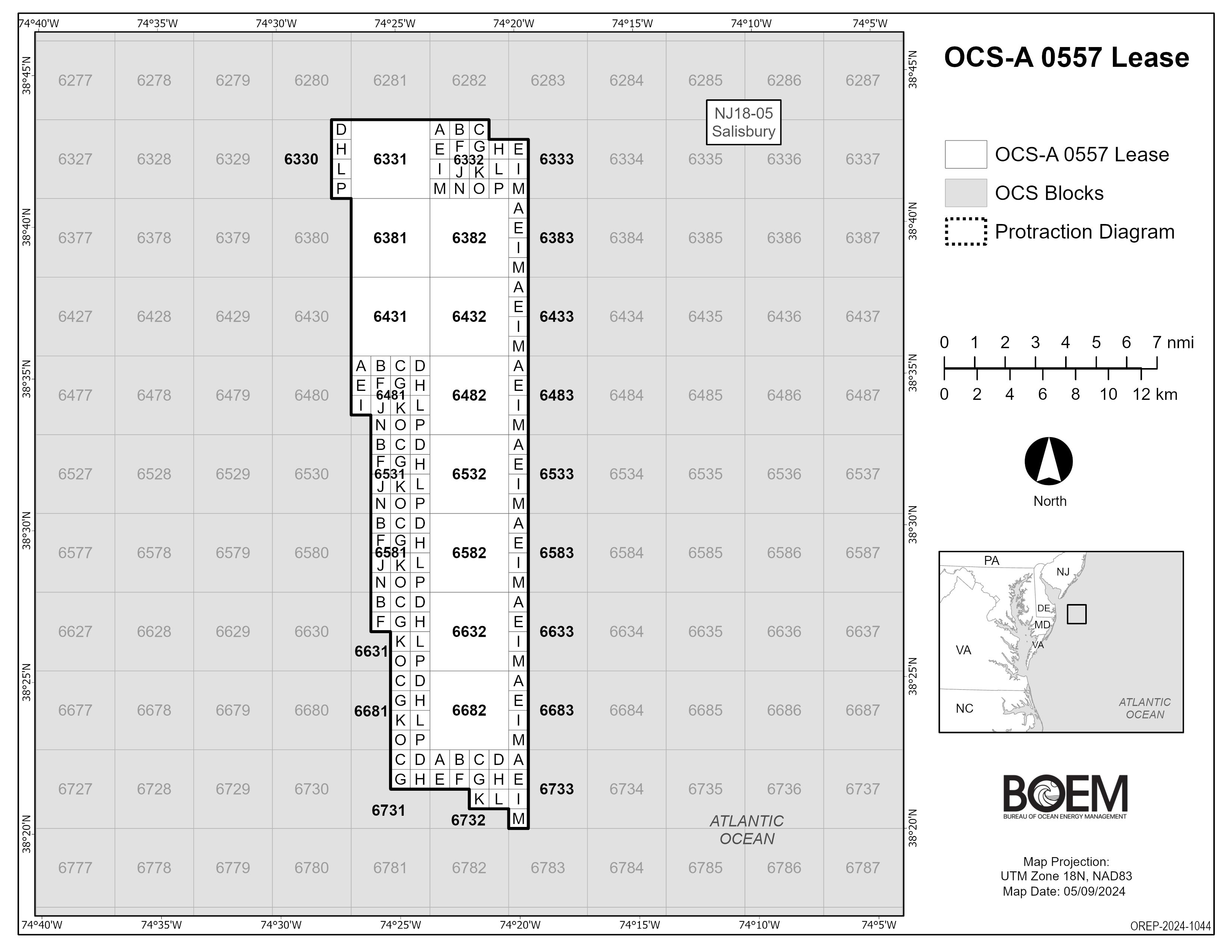
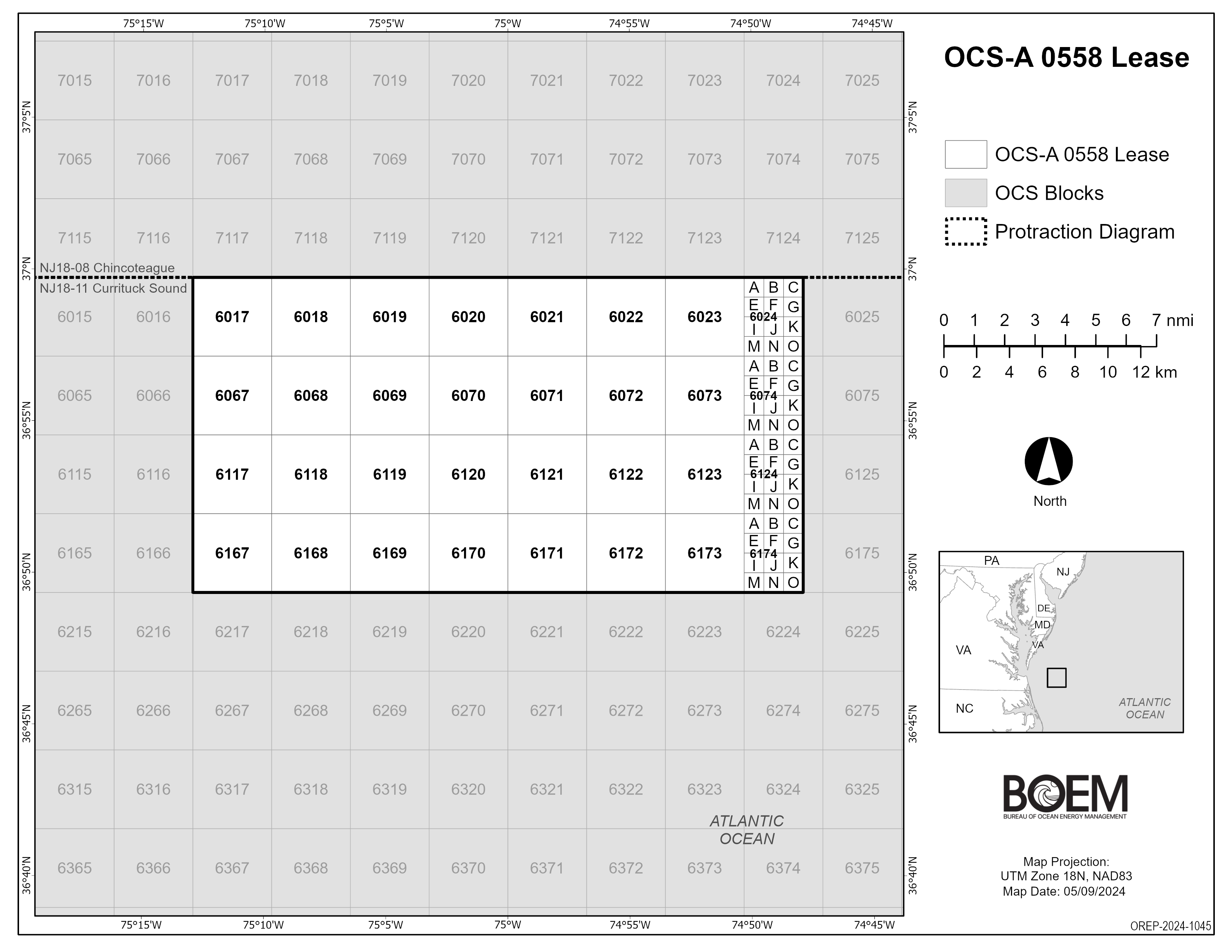
Equinor Wind US LLC provisionally won Lease OCS-A 0557 at $75,001,001, which consists of 101,443 acres and is approximately 26 nautical miles (nm) from Delaware Bay. Virginia Electric and Power Co provisionally won Lease OCS-A 0558 at $17,650,500, which consists of 176,505 acres and is approximately 35 nm from the entrance of Chesapeake Bay. Six companies participated in the auction.
Press Release
Biden-Harris Administration’s Central Atlantic Offshore Wind Lease Sale Yields Nearly $93 Million (08/14/2024)
Call for Information and Nominations
On April 27, 2022, BOEM announced the publication of a Call for Information and Nominations (Call) to assess commercial interest in -- and obtain public input on -- potential wind energy leasing activities in federal waters of the Central Atlantic.
The 60-day public comment period closed on June 28, 2022, and comments can be viewed at https://www.regulations.gov/document/BOEM-2022-0023-0001/comment.
- Call for Information and Nominations-Commercial Leasing for Wind Power Development on the Central Atlantic Outer Continental Shelf (OCS)
- Call Area Shape Files
- Call Area Blocks
- Nautical Chart Map
During the comment period, BOEM received nominations of areas of interest from 3 developers. Each of the parties listed below has been legally, technically and financially qualified.
- Map of all Nominations Received
- Avangrid Renewables LLC
- US Mainstream Renewable Power Inc
- OW North America Ventures LLC
Draft WEAs Nautical Chart Map
Draft WEAs Shapefiles
Draft Wind Energy Areas
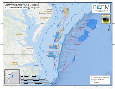
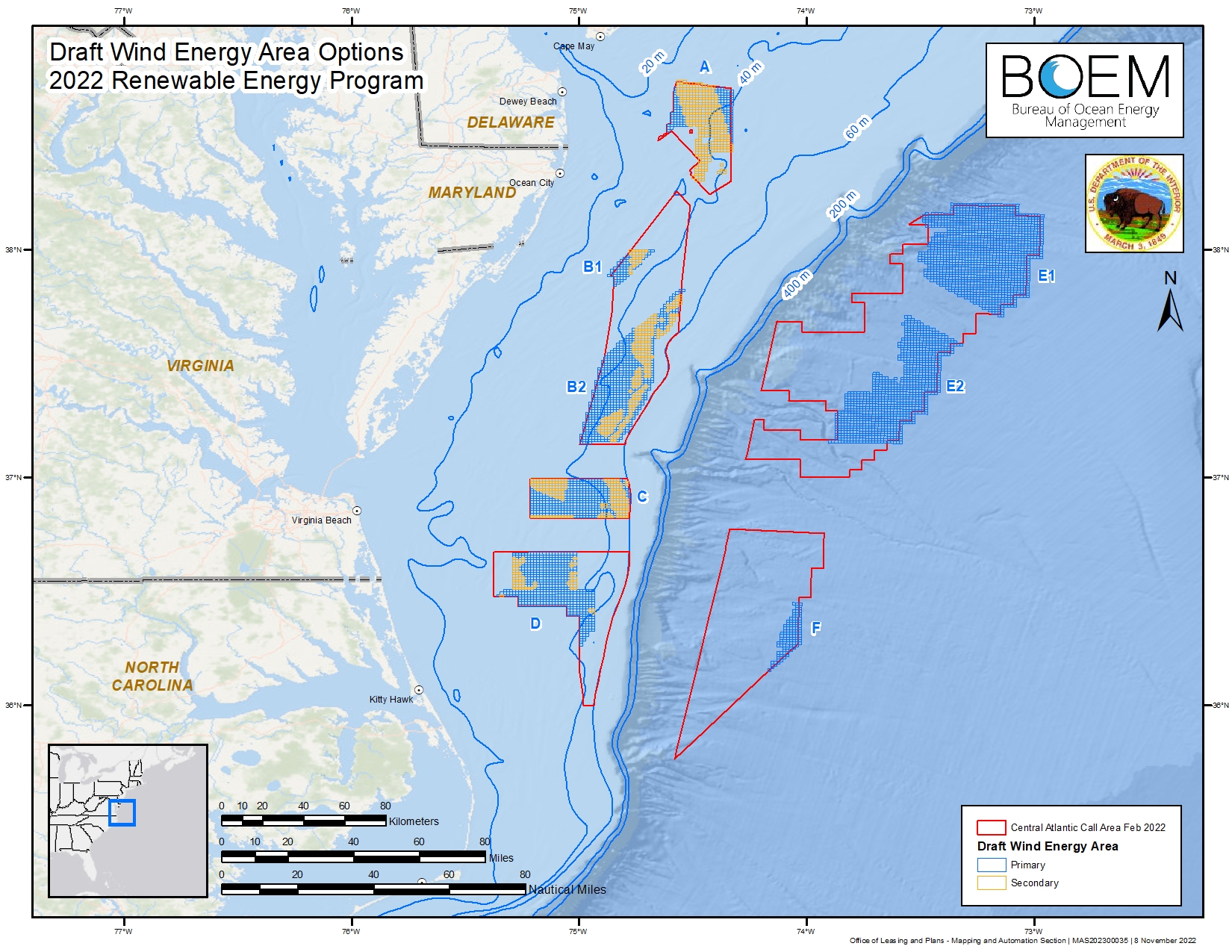
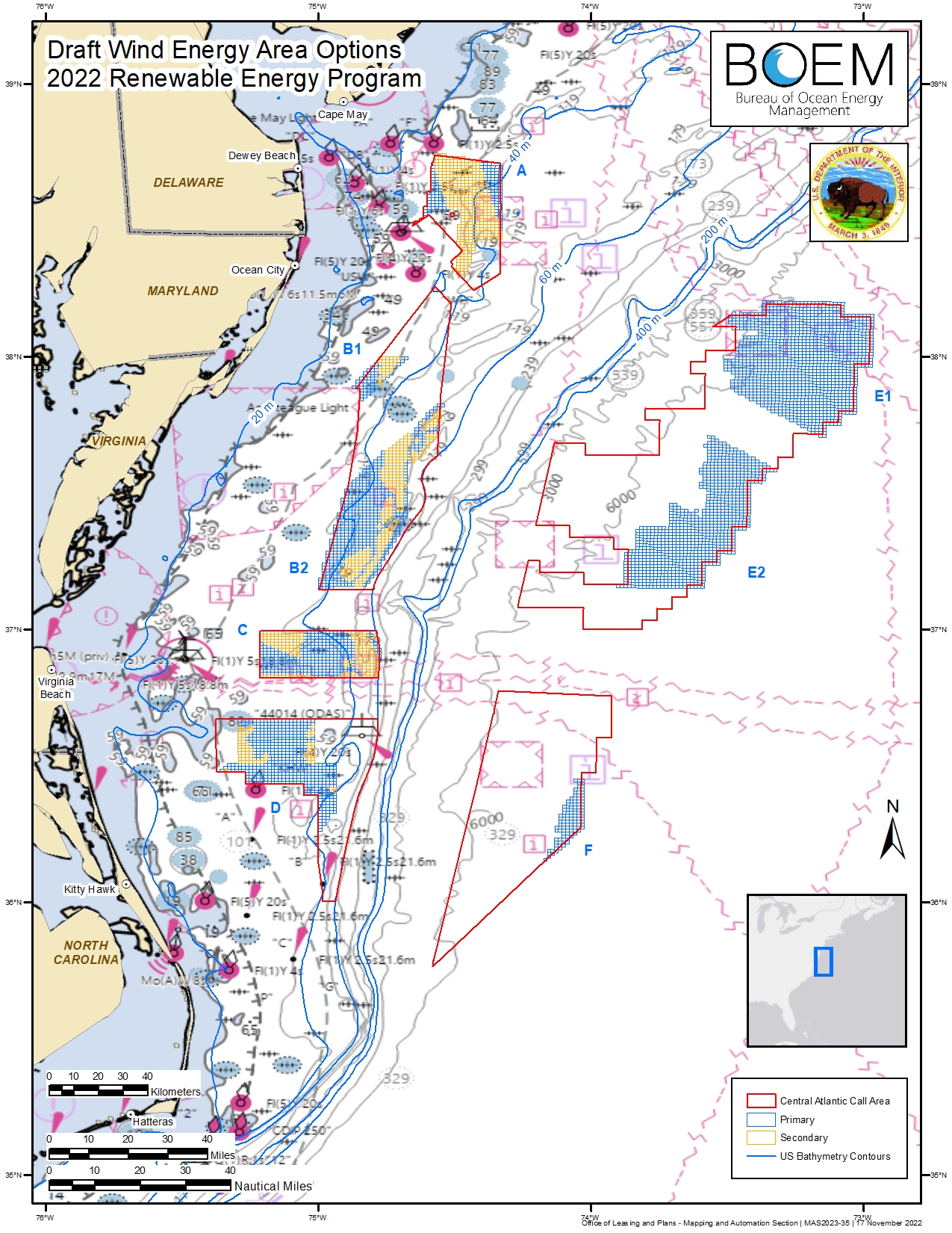
On Nov. 16, 2022, BOEM announced eight draft Wind Energy Areas (WEAs) in the Central Atlantic for public review and comment. The draft WEAs are in federal waters offshore North Carolina, Virginia, Maryland and Delaware. They cover approximately 1.7 million acres. Their closest points range from approximately 19 to 77 nautical miles off the Central Atlantic coast. The following documents are available in support of this announcement:
- BOEM and National Centers for Coastal Ocean Science Draft Report: Development of the Central Atlantic Wind Energy Areas (Nov. 2022)
- BOEM’s Request for Comments: Draft Wind Energy Areas (Nov. 16, 2022)
The eight draft WEAs represent a subset of the original 3.9 million acres of the Call Area that the Department of the Interior announced for public comment in April 2022.
Final WEAs
On July 31, 2023, BOEM announced three final Wind Energy Areas (WEAs) offshore Delaware, Maryland, and Virginia, which were developed following extensive engagement and feedback from states, Tribes, local residents, ocean users, federal government partners, and other members of the public. If fully developed, the final WEAs could support between four and eight gigawatts of energy production.
Description of the WEAs
- WEA A-2 is 101,767 acres and is located 26 nautical miles (nm) from Delaware Bay.
- WEA C is 176,506 acres offshore and is located about 35 nm offshore of the Chesapeake Bay, Va.
- WEA B-1 is undergoing an in-depth review to determine whether DoD and NASA activities can co-exist with offshore wind energy development.
The WEAs are in comparatively shallow water. BOEM may identify additional WEAs in deepwater areas offshore the U.S. Central Atlantic coast for future leasing once further study of those areas has been done.
- Memorandum for Area ID in the Central Atlantic
- Appendix A - Draft WEA Summary of Comments
- Appendix B - WEA Final Report NCCOS
Environmental Review
BOEM published its Notice of Intent (NOI) to prepare an environmental assessment of potential impacts from offshore wind leasing in the WEAs in the Federal Register on August 1, 2023, which initiated a 30-day public comment period.
On Oct. 10, 2023, BOEM hosted a virtual meeting for the Central Atlantic Intergovernmental Renewable Energy Task Force. The purpose of the meeting was to::
- Obtain feedback on the next steps in the offshore renewable energy process.
- Discuss issues and concerns from Task Force members, stakeholders, and the public.
- Share information about ocean uses and biological and physical resources.
- Facilitate ongoing conversations and collaboration opportunities.
Task force members include Tribal, Federal, state, and local government officials.
Proposed Sale Notice
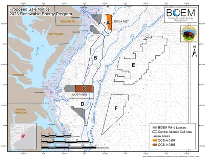
On Dec. 11, 2023, the Department of the Interior announced a proposed lease sale for the Central Atlantic. The proposed lease sale includes one area offshore the States of Delaware and Maryland, and one area offshore the Commonwealth of Virginia. Lease Area A-2 consists of 101,443 acres and is approximately 26.4 nautical miles (nm) from Delaware Bay. Lease Area C-1 consists of 176,505 acres and is approximately 35 nm from the mouth of the Chesapeake Bay. BOEM is seeking public comments on which, if any, of the two lease areas should be offered in a lease sale next year. These areas have the potential to power over 2.2 million homes with clean energy.
- Proposed Sale Notice (12/12/2023)
- Bidder's Financial Form (BFF)
- BFF Addendum
- Lease OCS-A 0557 (modified 7/15/24) and associated map
- Lease OCS-A 0558 (modified 7/15/24) and associated map
- Shapefile
Public Auction Seminar
On Jan. 9, 2024. BOEM announced it would hold an offshore wind auction seminar on January 17, 2024, for prospective bidders, which will be open to the public. The seminar will describe the auction format, explain the auction rules and demonstrate the auction process through meaningful examples. Please check the Central Atlantic Proposed Lease Sale Public Auction Seminar page for more information.
Draft Environmental Assessment
On Jan. 11, 2024, BOEM announced that it will publish a notice of availability (NOA) of a Draft Environmental Assessment (Draft EA) that assesses the potential impacts associated with possible wind energy-related leasing, site assessment, and site characterization activities on the U.S. Atlantic Outer Continental Shelf. The Draft EA, which published in the Federal Register on Jan. 12, 2024, will inform BOEM’s decision whether to issue wind energy leases in the Central Atlantic Wind Energy Areas.
The Draft EA considers the reasonably foreseeable environmental consequences of site characterization surveys (i.e., biological, archeological, geological, and geophysical surveys and core samples) and site assessment activities (i.e., installation of meteorological buoys), which are expected to take place following lease issuance.
- Notice of Availability of Central Atlantic Draft EA (BOEM-2024-0004)
- Draft EA and Appendices: Commercial Wind Lease Issuance and Site Assessment Activities on the Atlantic Outer Continental Shelf of the Central Atlantic
The NOA initiated a 30-day public comment period that ended at 11:59 p.m. Eastern Time on Feb. 12, 2024. During the public comment period, BOEM hosted two virtual meetings to allow the public to learn more about the Draft EA, ask questions, and provide oral testimony.
For more information on the public meetings, please see the Environmental Review tab above.
On June 6, 2024, BOEM announced the availability of its final environmental assessment (EA) assessing possible impacts from issuing leases for potential offshore wind development off the Delaware, Maryland, and Virginia coasts, including site assessment and site characterization activities such as geophysical, geological, and archaeological surveys. The EA concluded that there would be no significant impacts from lease issuance. The next step in the process is for the bureau to issue a final sale notice.
On June 7, the Department of the Interior announced a Memorandum of Understanding (MOU) between the Bureau of Ocean Energy Management (BOEM) and the State of Maryland to support the coordinated development of wind energy generation offshore Maryland.
- Maryland-BOEM MOU on Offshore Wind (June 7, 2024)
Final Sale Notice
On June 28, 2024, BOEM announced the Final Sale Notice (FSN) for offshore wind leasing on the Outer Continental Shelf (OCS) in the U.S. Central Atlantic. The FSN set the auction for August 14, 2024. The FSN includes one area offshore the States of Delaware and Maryland, and one area offshore the Commonwealth of Virginia. Lease Area A-2 consists of 101,443 acres and is approximately 26 nautical miles (nm) from Delaware Bay. Lease Area C-1 consists of 176,505 acres and is approximately 35 nm from the mouth of the Chesapeake Bay. Seventeen companies qualified to participate in the August sale. The two areas have the potential to power up to 2.2. million homes with clean energy. The FSN, which published in the Federal Register on July 1, 2024, contained information about the areas available for leasing, certain lease provisions and conditions, auction details, criteria for evaluating competing bids and procedures for lease award, appeals and lease execution.
- Final Sale Notice
- Bidder's Financial Form (BFF)
- BFF Addendum
- Payment Instruction
- Lease OCS-A 0557 (modified 7/15/24) and associated map
- Lease OCS-A 0558 (modified 7/15/24) and associated map
- Industry Comment and NASA Response
- Response to PSN Comments
- Shapefile
First Offshore Wind Energy Lease Sale
On August 14, 2024, BOEM held an offshore wind energy lease sale for two areas on the Outer Continental Shelf (OCS) off the Central Atlantic. The auction netted a total of $92,651,501 in high bids.
Equinor Wind US LLC provisionally won Lease OCS-A 0557 at $75,001,001, which consists of 101,443 acres and is approximately 26 nautical miles (nm) from Delaware Bay. Virginia Electric and Power Co provisionally won Lease OCS-A 0558 at $17,650,500, which consists of 176,505 acres and is approximately 35 nm from the entrance of Chesapeake Bay. Six companies participated in the auction.
Second Central Atlantic Call
On August 21, 2024, BOEM announced that it will publish a Call for Information and Nominations for a second offshore wind sale in the Central Atlantic. This Central Atlantic Call Area is more than 13 million acres located off the coasts of New Jersey, Delaware, Maryland, Virginia and North Carolina.
The Call for Information published in the Federal Register on August 22, initiating a 60-day comment period ending on October 21, 2024. After the public comment period closes, BOEM will review and analyze commercial nominations and public comments submitted in response to the Call. BOEM anticipates this second offshore wind sale in the Central Atlantic will build upon the input and planning that led to the recent first Central Atlantic lease sale on August 14, 2024.
Central Atlantic Final EA
On June 7, 2024, BOEM published the “Notice of Availability of a Final Environmental Assessment for Commercial Wind Lease and Site Assessment Activities on the Atlantic Outer Continental Shelf of the Central Atlantic” in the Federal Register.
After carefully considering alternatives described and analyzed in the Final Environmental Assessment (Final EA), as well as comments from the public and cooperating and consulting agencies on the Draft EA, BOEM has found there would be no significant impact on the environment as a result of lease issuance.
Central Atlantic Draft EA
On Jan. 11, 2024, BOEM announced that it will publish a notice of availability (NOA) of a Draft Environmental Assessment (Draft EA) that assesses the potential impacts associated with possible wind energy-related leasing, site assessment, and site characterization activities on the U.S. Atlantic Outer Continental Shelf. The Draft EA, published in the Federal Register on Jan. 12, will inform BOEM’s decision whether to issue wind energy leases in the Central Atlantic Wind Energy Areas.
The Draft EA considers the reasonably foreseeable environmental consequences of site characterization surveys (i.e., biological, archeological, geological, and geophysical surveys and core samples) and site assessment activities (i.e., installation of meteorological buoys), which are expected to take place following lease issuance.
- Notice of Availability of Central Atlantic Draft EA (BOEM-2024-0004)
- Draft EA and Appendices: Commercial Wind Lease Issuance and Site Assessment Activities on the Atlantic Outer Continental Shelf of the Central Atlantic
Central Atlantic Draft EA Resources