
- Project Overview
- Lease Assignment
- Site Assessment Plan
- Construction & Operations Plan
- Environmental Review
- Visual Simulations
What's New?
On December 3, 2024, the Department of the Interior announced the approval of the Maryland Offshore Wind Project Construction and Operations Plan (COP). The project has the potential to generate up to 2,200 megawatts of clean, renewable energy for the Delmarva Peninsula and power over 718,000 homes. The project is located approximately 10 nautical miles offshore Ocean City, Maryland, and approximately 9 nautical miles offshore Sussex County, Delaware.
The approved COP includes up to 114 wind turbine generators, four offshore substations, a meteorological tower, and up to four offshore export cable corridors with subsea transmission cables making landfall in Sussex County, Delaware.
Please see the Construction and Operations Plan tab for more information.
Record of Decision
On September 5, 2024, the Department of the Interior announced the approval of the Maryland Offshore Wind Project – the nation’s tenth commercial-scale offshore wind energy project. The project could generate over 2 gigawatts of clean, renewable energy for the Delmarva Peninsula and power over 718,000 homes. Additionally, the development and construction phases of the project could support almost 2,680 jobs annually over seven years. The lease area is approximately 8.7 nautical miles offshore Maryland and approximately 9 nautical miles from Sussex County, Delaware, at its closest points to shore.
The Maryland Offshore Wind Project consists of three planned phases, which include the proposed installation of up to 114 wind turbine generators, up to four offshore substation platforms, one meteorological tower, and up to four offshore export cable corridors. Two phases, known as MarWin and Momentum Wind, already have offshore renewable energy certificates from the State of Maryland.
The following documents are available for your viewing.
Final Environmental Impact Statement
On July 29, 2024, BOEM announced the availability of the Final Environmental Impact Statement (FEIS) for the proposed Maryland Offshore Wind Project. The following documents are available for your viewing.
- Maryland Offshore Wind FEIS Notice of Availability (Docket No. BOEM-2024-0033)
- Maryland Offshore Wind Final Environmental Impact Statement
Please see the Environmental Review tab and Construction and Operations tab for additional information.
Background
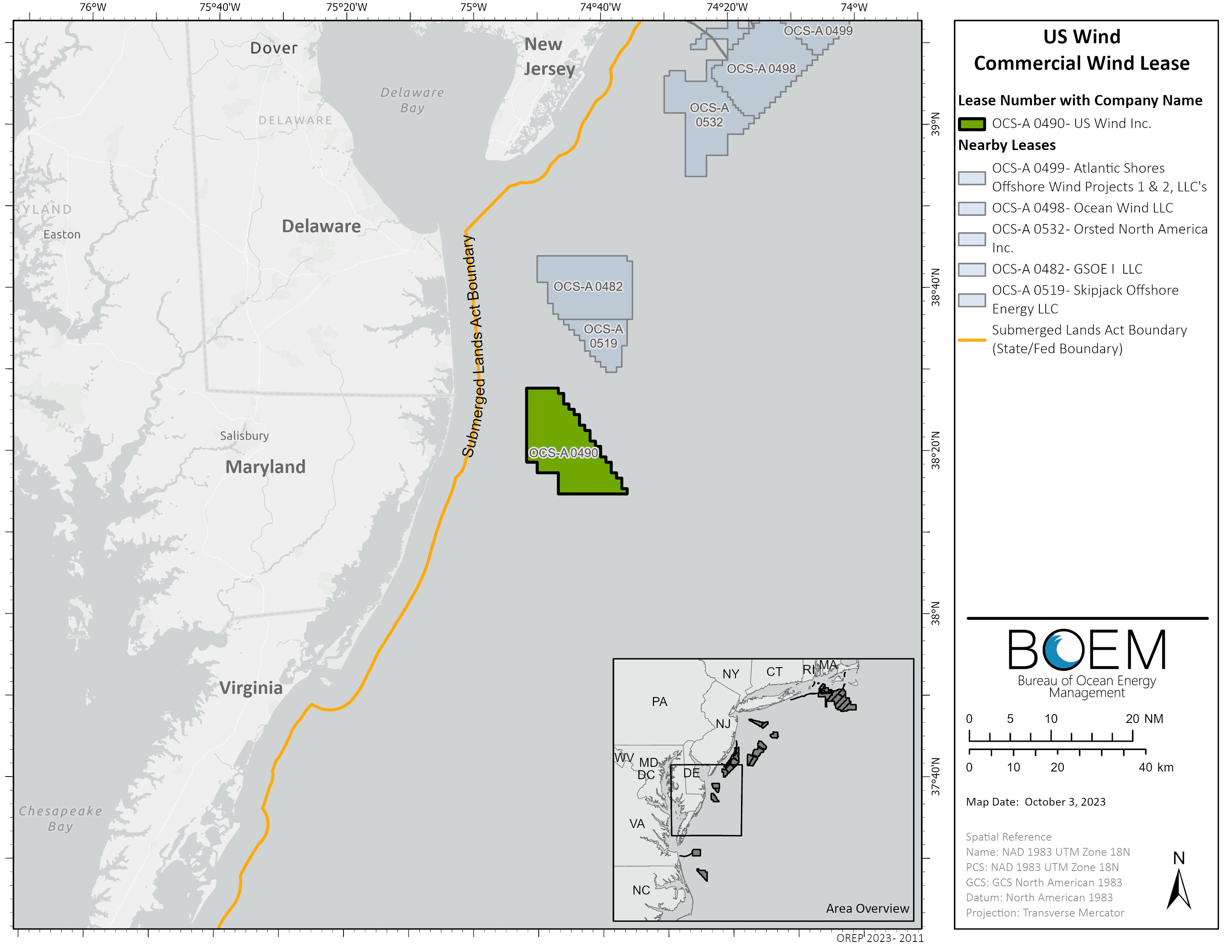
On August 19, 2014, BOEM held a competitive lease sale offshore Maryland. US Wind Inc. was identified as the winner of Lease Area OCS-A 0490 (46,970 acres) located 10 nautical miles offshore Ocean City, Maryland in federal waters. Maryland Offshore Wind is in the environmental review phase within BOEM’s authorization process. This project is covered under FAST-41 and permitting progress can be found on the Federal Permitting Improvement Steering Council (FPISC) dashboard.
For more information on this lease area, including Intergovernmental Renewable Energy Task Force meetings and lease history please visit the Planning and Lease Sale page. For more information on public meetings, please visit the Environmental Review tab. For up-to-date leasing information, including the original lease and any lease amendments that may have occurred since the initial lease execution, visit the Lease and Grants page.
Related Announcements
- BOEM Approves Construction and Operations Plan for Maryland Offshore Wind Project (12/03/2024)
- Biden-Harris Administration Marks Major Milestones for Offshore Wind, Approves Tenth Project (09/05/2024)
- BOEM Releases Final Environmental Impact Statement for Wind Energy Project Offshore Maryland (07/29/2024)
- BOEM Seeks Public Input on Draft Environmental Review of Proposed Wind Energy Project Offshore Maryland (09/29/2023)
- Department of the Interior Announces Environmental Review of First Proposed Wind Energy Project Offshore Maryland (06/06/2022)
Leases OCS-A 0489 and OCS-A 0490 were auctioned on August 19, 2014 through a competitive lease sale. The auction lasted 19 rounds and US Wind Inc. (US Wind) won with a total bid price of $8,701,098 for Leases OCS-A 0489 (North Lease) and OCS-A 0490 (South Lease). BOEM issued the commercial wind energy leases to US Wind effective December 1, 2014.
After securing the leases, US Wind requested to merge the two Lease Areas into a single lease. On January 10, 2018, BOEM approved US Wind’s request. By a lease amendment, made effective March 1, 2018 US Wind’s commercial leases were merged into a single lease, retaining the lease number OCS-A 0490. Lease OCS-A 0489 automatically terminated. The resulting Lease Area is approximately 79,707 acres.
On December 3, 2024, BOEM granted the project easement request associated with Lease OCS-A 0490. In association with granting the easement, Addendum A and Addendum D were revised.
Site Assessment Plan
On March 22, 2018, BOEM approved the Site Assessment Plan (SAP) for Lease OCS-A 0490 submitted by US Wind, Inc. The SAP approval allows for the installation of and data collection from a meteorological tower, a seabed mounted acoustic Doppler current profiler (ADCP) sensor and a conductivity, temperature, and depth (CTD) sensor. For additional information, please find the approved SAP below:
- SAP Approval for Lease OCS-A 0490
- SAP Conditions of Approval
- Site Assessment Plan for Lease OCS-A 0490
On October 22, 2020, US Wind, Inc. submitted a second SAP to BOEM for meteorological evaluations and site assessment. The plan details the methods and procedures U.S. Wind, Inc. will use to collect and analyze meteorological and oceanographic data and information on the conditions of the marine environment within its commercial lease. On May 5, 2021, BOEM approved the SAP for Lease OCS-A 0490, allowing for the installation of a meteorological buoy. For additional information, please find the approved SAP below:
On August 11, 2020 US Wind Inc. submitted a Construction and Operations Plan (COP) for Lease OCS-A 0490. On July 1, 2024 US Wind submitted an updated COP. This version of the COP informs the basis for the Final Environmental Impacts Statement (EIS).
On December 3, 2024, BOEM announced its approval of the Maryland Offshore Wind Project COP, which authorizes construction and operation of a commercial offshore wind energy facility. The project could have a total capacity of up to 2,200 megawatts of clean, renewable energy for the Delmarva Peninsula and power over 718,000 homes. The project is located within federal waters, specifically in BOEM Renewable Energy Lease Area OCS-A 0490, approximately 10 nautical miles offshore Ocean City, Maryland, and approximately 9 nautical miles offshore Sussex County, Delaware. The approved COP includes up to 114 wind turbine generators, four offshore substations, a meteorological tower, and up to four offshore export cable corridors with subsea transmission cables making landfall in Sussex County, Delaware.
The project includes MarWin, a wind farm of approximately 300 MW for which US Wind was awarded offshore wind renewable energy credits (ORECs) in 2017 by the State of Maryland; Momentum Wind, consisting of approximately 808 MW for which the State of Maryland awarded additional ORECs in 2021; and build out of the remainder of the Lease Area to fulfill ongoing, government-sponsored demands for offshore wind energy.
Notice of Intent to Prepare a Draft Environmental Impact Statement (NOI EIS)
On June 6, 2022, BOEM announced the intent to prepare a draft Environmental Impact Statement for the Maryland Offshore Wind project. The Notice of Intent (NOI) was published in the Federal Register on June 8, 2022. The following documents are available for your viewing:
The Notice of Intent initiated a 30-day public comment period that ended on July 8, 2022.
- Tuesday, June 21, 2022
Meeting Recording - Thursday, June 23, 2022
Meeting Recording - Monday, June 27, 2022
Meeting Recording
Draft Environmental Impact Statement (Draft EIS)
On September 29, 2023, BOEM announced the availability of the draft EIS for the proposed Maryland Offshore Wind project. The Notice of Availability and draft EIS can be accessed using the links below.
- Maryland Offshore Wind Draft EIS Notice of Availability (Docket No. BOEM-2023-0050)
- Maryland Offshore Wind Draft Environmental Impact Statement (Draft EIS)
Two in-person meetings and two virtual meetings were held during the 45-day draft EIS comment period. In-person meetings followed an informal open house format where attendees were given the opportunity to ask questions one-on-one of BOEM subject matter experts and to submit oral and written comments for the record. During each virtual meeting, BOEM provided an overview presentation, after which members of the public made formal oral public statements for the record. The public meetings were held on the following dates:
- Thursday, October 19, 2023
Virtual - Meeting Recording
- Tuesday, October 24, 2023
In-Person - Ocean City, MD
- Thursday, October 26, 2023
In-Person - Dagsboro, DE
- Monday, October 30, 2023 Virtual – Meeting Recording
More information can be found in the Virtual Meeting Room.
Final Environmental Impact Statement (Final EIS)
On July 29th, 2024, BOEM announced the availability of the final Environmental Impact Statement for the Maryland Offshore Wind project. The Notice of Availability (NOA) will be available in the Federal Register on August 2, 2024. The following documents are available for your viewing:
- Maryland Offshore Wind FEIS Notice of Availability (Docket No. BOEM-2024-0033)
- Maryland Offshore Wind Final Environmental Impact Statement
On August 22, 2024, BOEM published an Errata on its website that included correction to Chapter 2, Chapter 3, Appendix E, Appendix G, Appendix H, and Appendix I. None of these edits or corrections are substantive or affect the analysis or conclusions in the FEIS. Erratum #4 should reference Section E.1.1, not Section E.1.2.
- Errata for the Maryland Offshore Wind Final EIS
- The EIS with errata incorporated is available in Maryland Offshore Wind Final Environmental Impact Statement (EIS) page
Joint Record of Decision
On September 5, 2024, the Department of the Interior announced the approval of the Maryland Offshore Wind Project – the nation’s tenth commercial-scale offshore wind energy project. The project could generate over 2 gigawatts of clean, renewable energy for the Delmarva Peninsula and power over 718,000 homes. Additionally, the development and construction phases of the project could support almost 2,680 jobs annually over seven years. The lease area is approximately 8.7 nautical miles offshore Maryland and approximately 9 nautical miles from Sussex County, Delaware, at its closest points to shore.
The following documents are available for your viewing.
Visual Impact Assessment
The visual impact assessment includes photo simulations of the proposed Maryland Offshore Wind Project from numerous Key Observation Points (KOPs) and provides a detailed analysis of the potential visibility of the proposed Project and differences in landscape visual quality with and without the Project in place. A video simulation was also produced viewing from KOP 6: 84th Street Beach.
In addition, photo-simulations were produced for Alternative D – No Surface Occupancy to Reduce Visual Impacts Alternative.
BOEM recommends viewing the simulations in accordance with the instructions below for viewing printed photos or on-screen viewing to fully understand the overall horizontal and vertical size and scale of the project represented in the photo simulations. Each simulation contains instructions for viewing with a scaling bar. Once the scale is set, it is likely that the simulation will be larger than the monitor’s screen.
Photo simulations are presented in two formats: panoramic photo format, which approximates the human-field-of-view, and single frame photo format taken with a 50 mm lens on a 35 mm full-frame camera, which represents the “normal” camera lens field-of-view. Each format set has a purpose.
The panoramic photo format approximates the human field-of-view and illustrates the horizontal breadth a person may see when standing at the location and looking in the direction the photo was taken. This photo informs the viewer how much of horizontal span of view would be occupied by the project without moving the head from side to side. However, the panoramic photo simulation does not properly illustrate the vertical size and scale of the wind turbines and other offshore facilities associated with the wind energy development.
The single frame photo taken with a 50 mm lens on a 35 mm full-frame camera approximates the size and scale of the project’s offshore wind turbines and other associated offshore facilities at the photo-point location. However, the horizontal field-of-view in the single frame is considerably less than the human field-of-view.
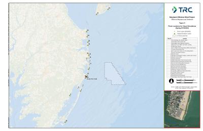
Photo simulations of the proposed Maryland Wind Offshore Wind Project from all KOPs (see Map Figure 1-KOPs and KOPs with simulations) may be viewed or downloaded in the following:
- Maryland Offshore Wind Project Photo-Simulations from North to South (see Map for locations of simulation KOPs)
- Wildwood Boardwalk (KOP 23)
- Cape May Lighthouse (KOP 21)
- Fort Miles Historic District, Cape Henlopen (KOP 22)
- Rehoboth Beach Boardwalk (KOP 24)
- Delaware Seashore State Park (KOP 20)
- Indian River Life Saving Station (KOP 19)
- Bethany Beach Boardwalk and Wreck Site (KOP 15)
- 84th Street Beach (KOP 6)
- Ocean City Pier/Atlantic Hotel (KOP 1)
- Assateague Island National Seashore (KOP 3)
- Mansion House (KOP 4)
- Assateague Beach (Toms Cove) (KOP 25)
- Maryland Offshore Wind Video-Simulation*
- 84th Street Beach (KOP 6)
This video simulation contains music but no words or spoken descriptions.
- 84th Street Beach (KOP 6)
- O&M Facility Simulations
- Cumulative Effects Simulations (updated from the DEIS) by KOP from North to South (see Map Figure 1 for cumulative effects simulation KOPs).
- Scenario 1: Simulation showing lease areas that may potentially be developed before Maryland Offshore Wind (leases shown include Ocean Wind, Atlantic Shores Offshore Wind-South)
- Scenario 2: Simulation showing Maryland Offshore Wind added to the lease areas potentially developed before Maryland Offshore Wind (leases shown include Maryland Offshore Wind, Ocean Wind, Atlantic Shores Offshore Wind-South)
- Scenario 3: Simulation showing total buildout - lease areas potentially developed after Maryland Offshore Wind added to the simulation (leases shown include Skipjack Wind, Garden State Offshore Energy, Maryland Offshore Wind, Ocean Wind, Atlantic Shores Offshore Wind-South)
- Scenario 4: Simulation showing total buildout minus Maryland Offshore Wind (leases shown include Skipjack Wind, Garden State Offshore Energy, Maryland Offshore Wind, Ocean Wind, Atlantic Shores Offshore Wind-South)
- Scenario 5: Simulation showing only the Maryland Offshore Wind lease
- Cape May Lighthouse (KOP 21)
- Delaware Seashore State Park (KOP 20)
- Bethany Beach (KOP 15)
- 84th Street Beach (KOP 6)
- Ocean City Boardwalk (KOP 1)
- Assateague Island National Seashore (KOP3)
*As part of the COP review, a time-lapse video was produced that depicts daytime and nighttime conditions under a variety of lighting conditions (including nighttime), cloud cover, and weather scenarios. As discussed in Appendix II-J (Visual Impact Assessment) of the COP, based on past flight data and the use of Aircraft Detection Lighting Systems (ADLS), the aviation obstruction lights associated with the project would only be activated for a total of approximately 5 hours and 46 minutes over a one-year period, or 1% of the time. The simulation is at the proper perspective when viewed at a distance of approximately twice the image height.
Cumulative Historic Resources Visual Effects Analysis (CHRVEA)
The BOEM Cumulative Historic Resources Visual Effects Analysis (CHRVEA) provides an assessment of the Project’s contribution to cumulative visual effects on historic properties when combined with other reasonably foreseeable offshore wind energy development activities in the area.
The CHRVEA can be accessed here:
- Cumulative Historic Resources Visual Effects Analysis – Maryland Offshore Wind Project