
What's New
The Department of the Interior and BOEM are implementing President Trump’s memorandum temporarily halting offshore wind leasing on the Outer Continental Shelf. The memorandum also pauses new or renewed approvals, rights-of-way, permits, leases, or loans for offshore wind projects pending a review of federal wind leasing and permitting practices.
BOEM Postpones Oregon Offshore Wind Energy Auction (September 27, 2024)
Final Sale Notice
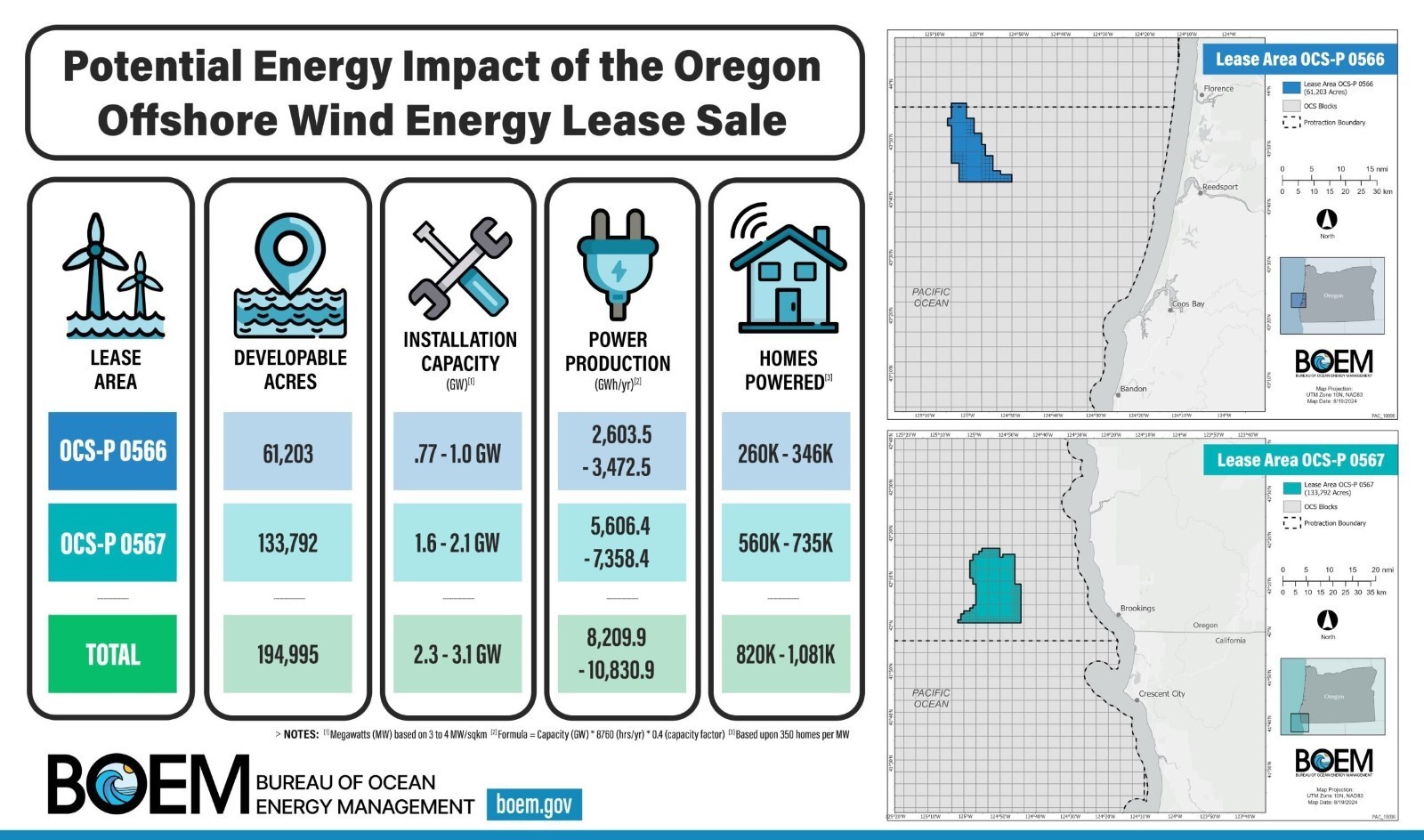
On August 29, 2024, the Department of Interior announced the Final Sale Notice (FSN) for offshore wind leasing on the Outer Continental Shelf (OCS) offshore Oregon. The FSN set an auction date for October 15, 2024, that included two lease areas offshore Oregon. Five companies were qualified to participate in the sale. The two lease areas have the potential to power approximately one million homes with clean energy. The FSN also contained information about the lease areas, certain lease provisions and conditions, auction details, the lease form, criteria for evaluating competing bids and procedures for lease award, appeals and lease execution.
Materials related to the FSN and the PACW-2 lease sale are below.
- Final Sale Notice (FSN)
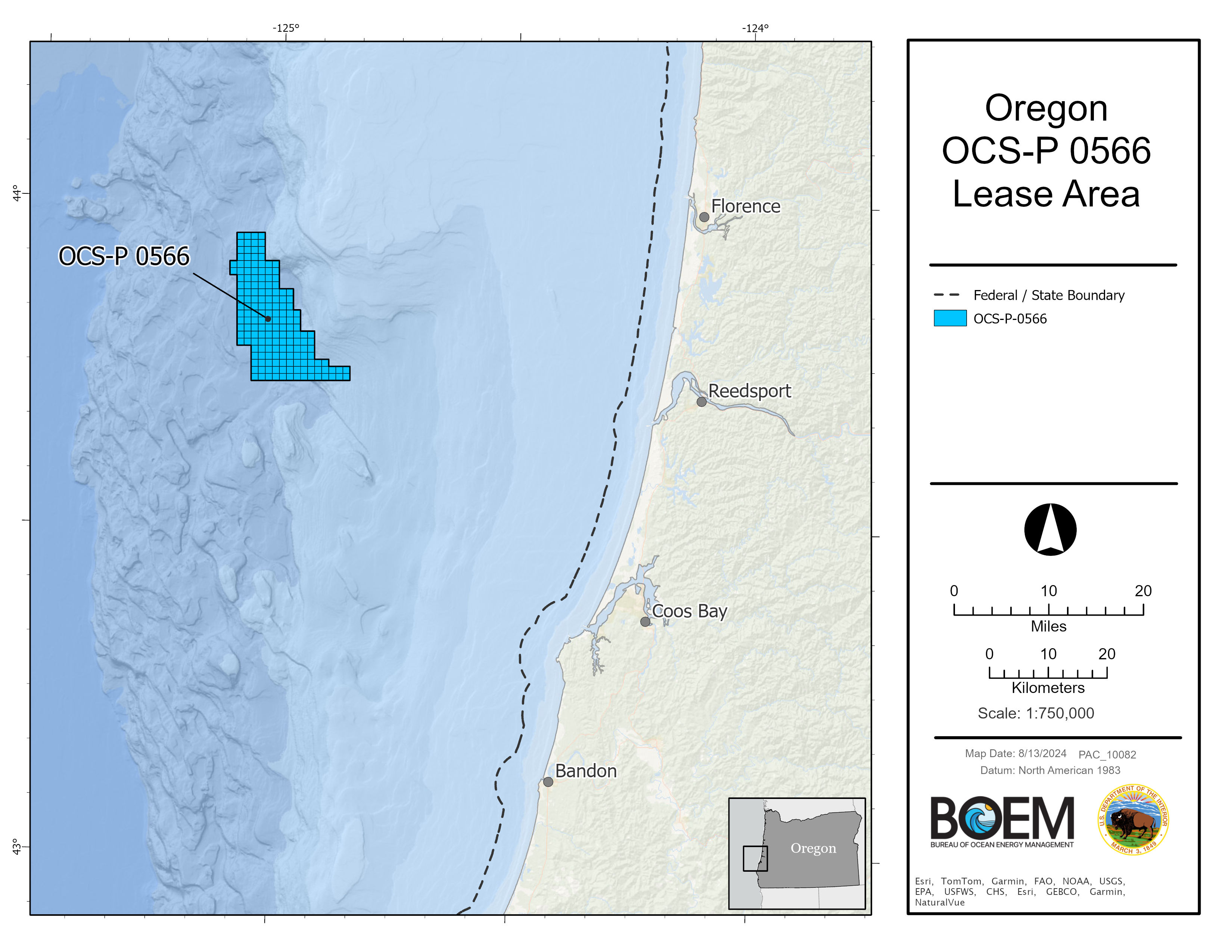
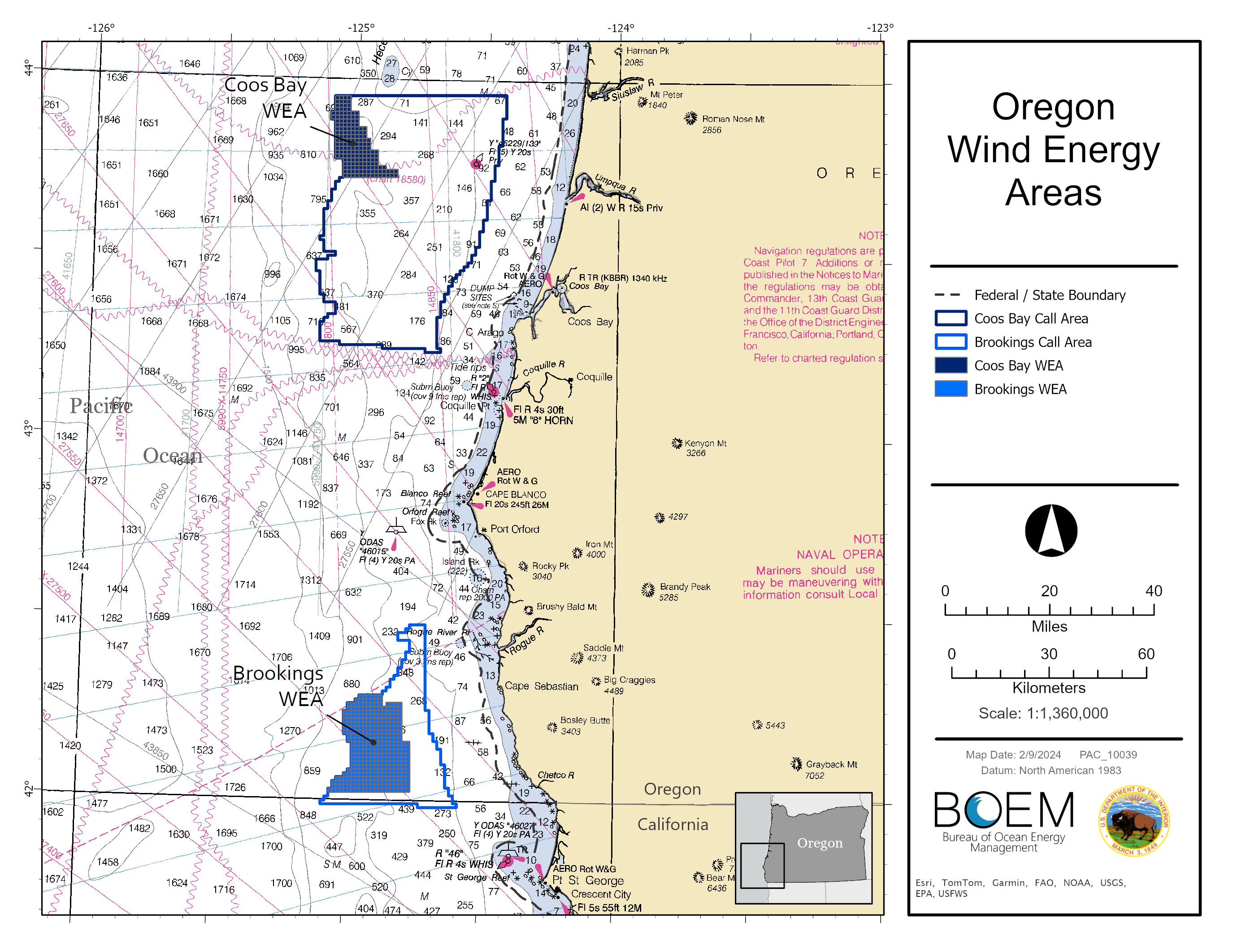
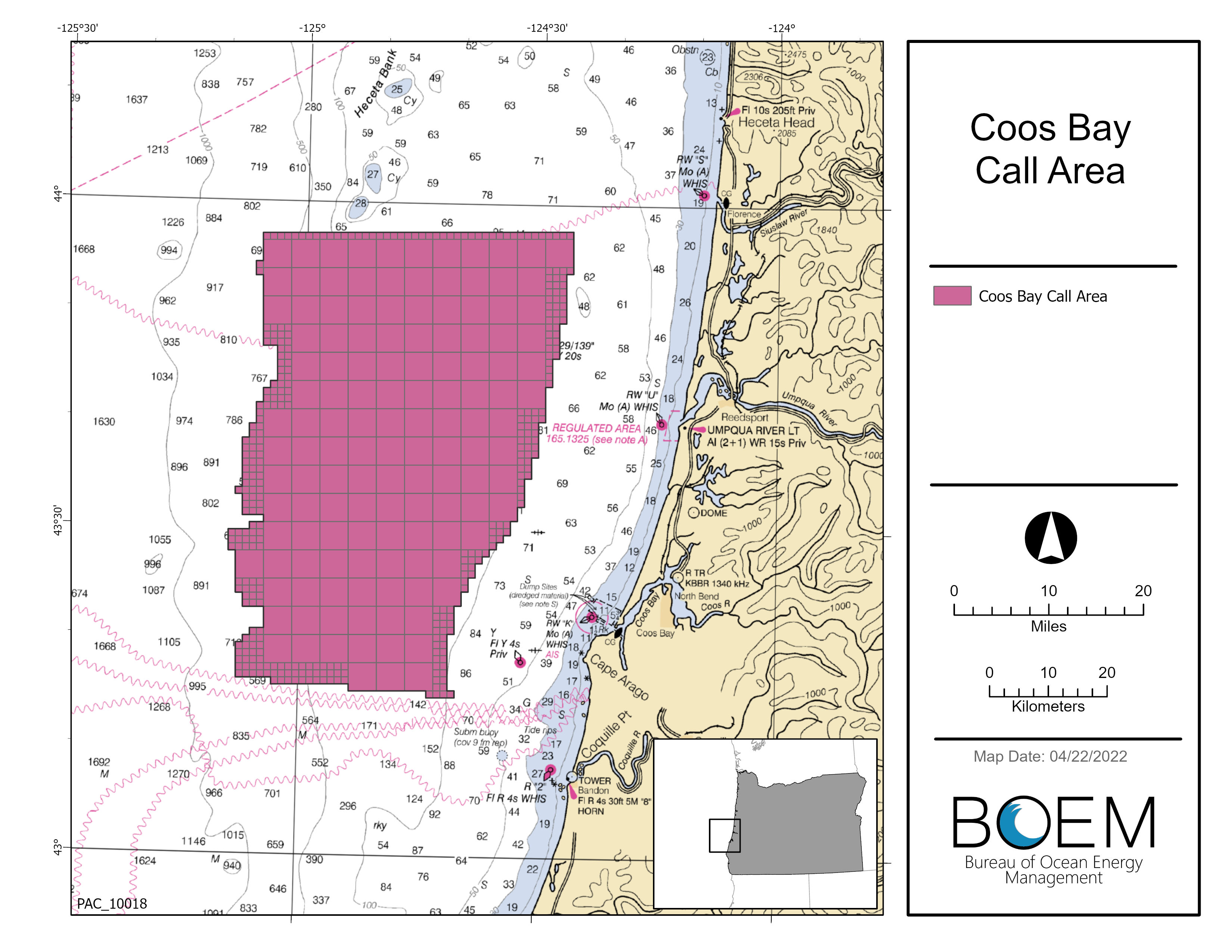
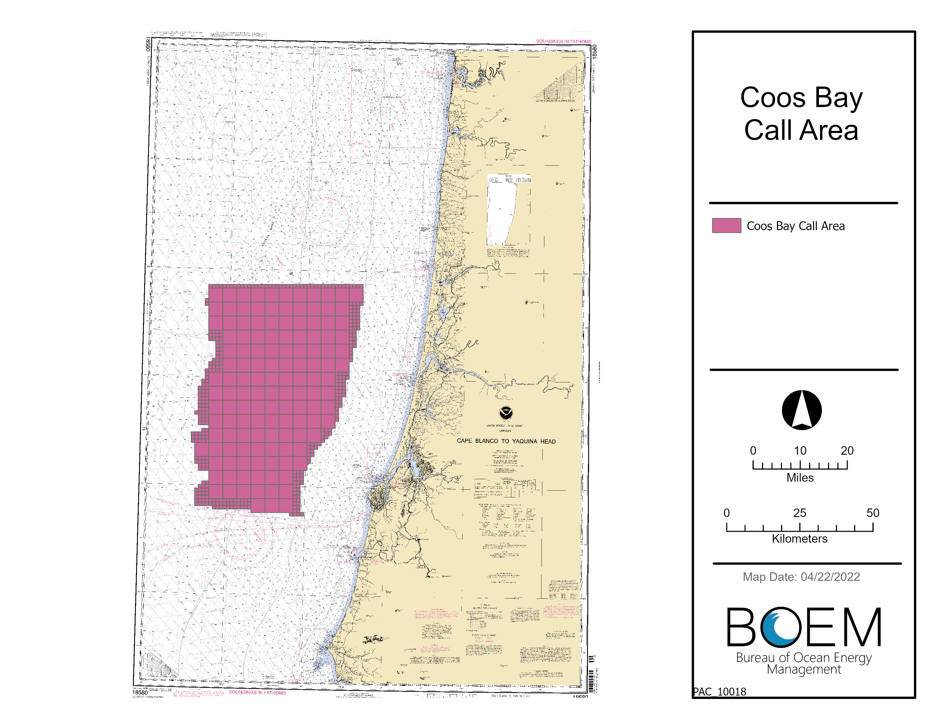
- OR Lease OCS-P 0566 (Coos Bay) and associated map
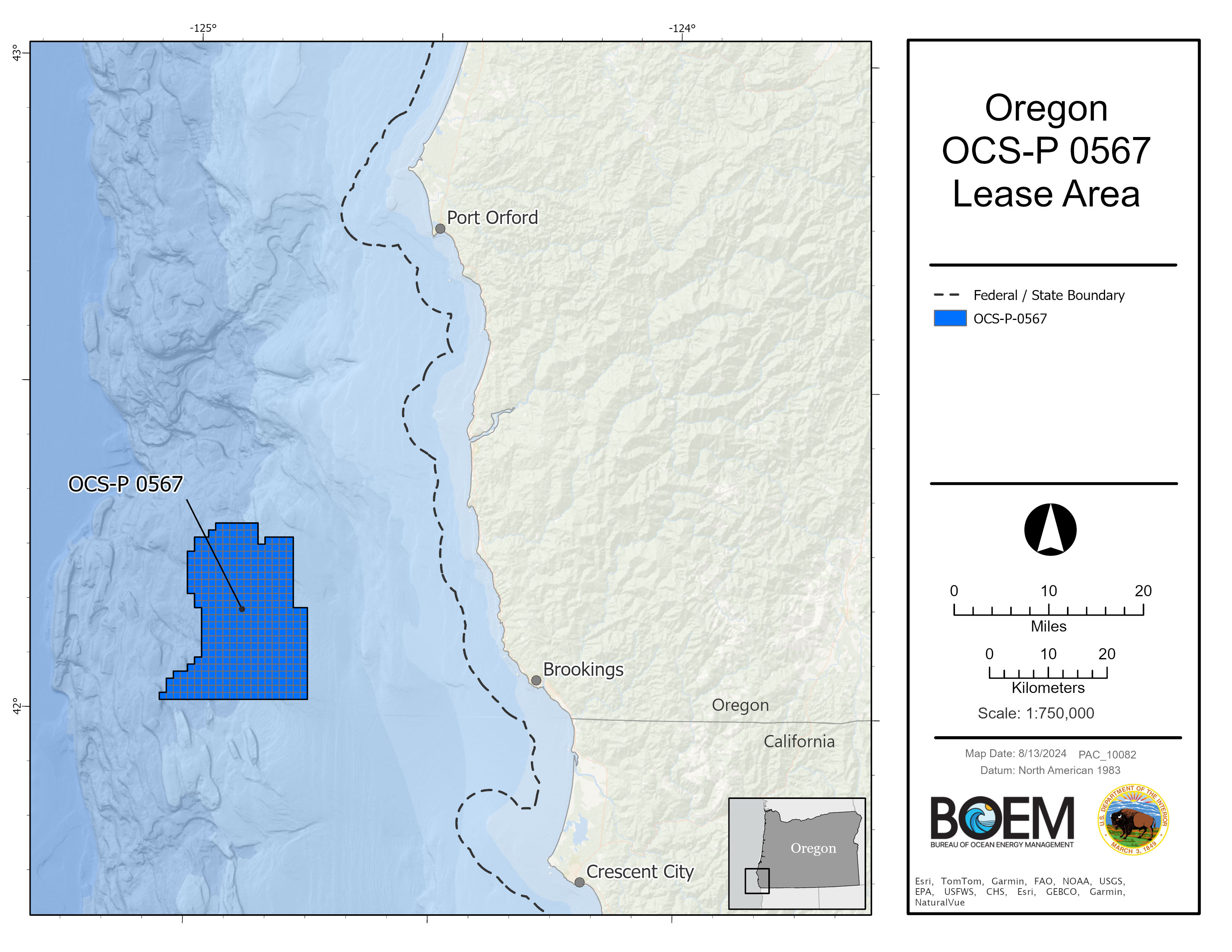
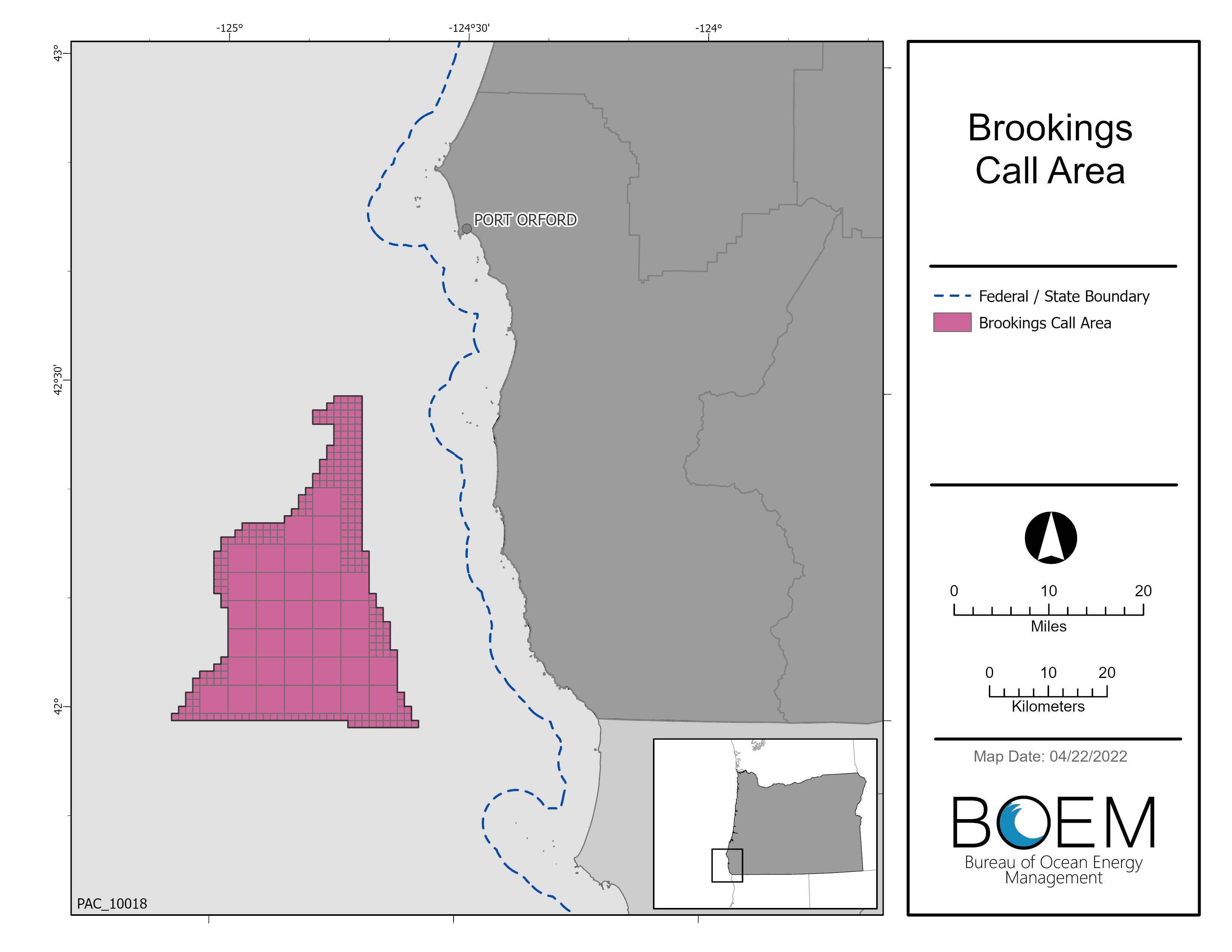
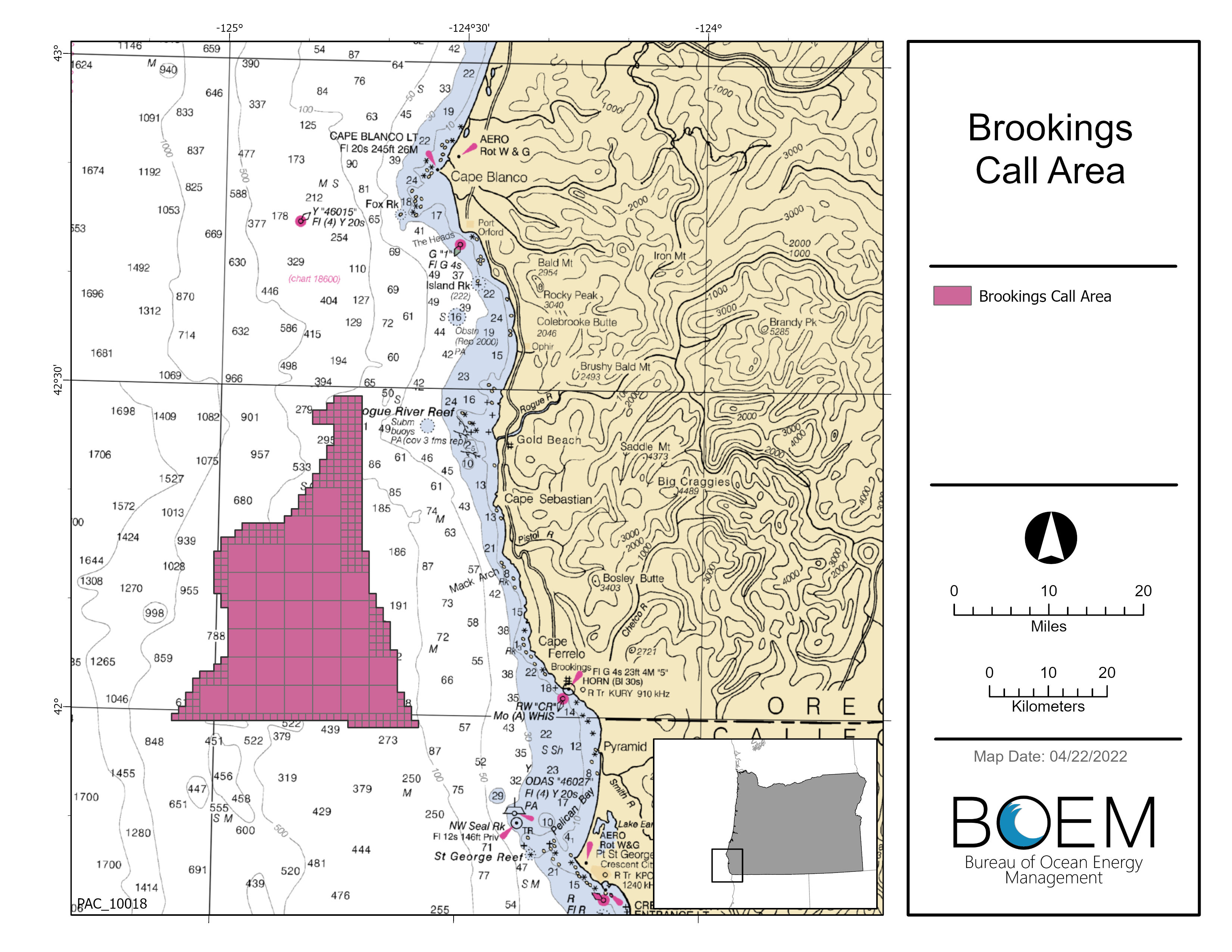
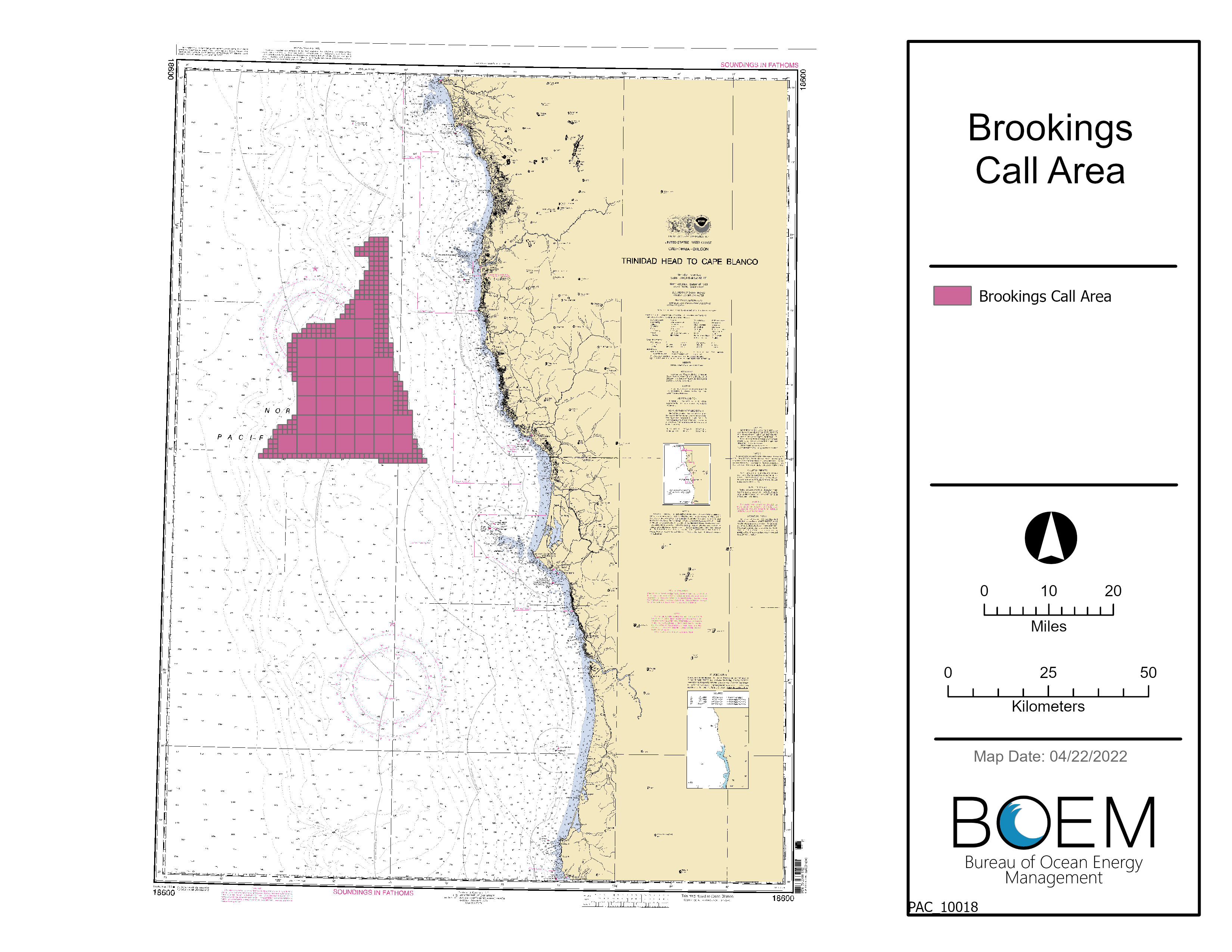
- OR Lease OCS-P 0567 (Brookings) and associated map
- FSN Decision Memorandum
- Bidders Financial Form
- Bidders Financial Form Addendum
- PSN Response to Comments
- Shapefiles
Renewable Energy Modernization Rule
On May 15, 2024, BOEM published in the Federal Register the Renewable Energy Modernization Rule (Rule), which went into effected on July 15, 2024. The Modernization Rule requires updates to the lease published with this FSN. The updates reflect changes to the timing of the lease terms and the formula for calculating operating fees. After July 15, 2024, BOEM revised the lease to conform to the Rule and informed bidders of the changes.
How Did We Get Here?
This Proposed Sale Notice (PSN) reflects a multi-year planning process that has included robust engagement with Tribes, local communities, federal and state agencies, ocean users, and stakeholders to balance the complex social, ecological, and economic factors in Oregon. See the History tab for more background and history.
BOEM’s strategic partnership with the National Oceanic and Atmospheric Administration’s National Centers for Coastal Ocean Science has enhanced this process and incorporated the best available ocean resource information to inform wind energy areas. These efforts, summarized in the video and StoryMap on this page, are designed to set an informed foundation to deconflict multiple ocean uses in areas of future offshore wind energy development.
Related Announcements
- BOEM Postpones Oregon Offshore Wind Energy Auction (September 27, 2024)
- BOEM Finalizes Environmental Review of Wind Leases Offshore Oregon (August 13, 2024).
- You’re Invited: Oregon Proposed Lease Sale Public Auction Seminar (May 30, 2024)
- Comment Period Extended on Draft Environmental Assessment on Oregon Offshore Wind Leasing Activities (May 30, 2024)
- You’re Invited: BOEM to Hold Virtual Public Meetings on Proposed Offshore Wind Lease Auction and Draft Environmental Assessment for Oregon (May 14, 2024)
- You're Invited: Virtual BOEM Oregon Intergovernmental Renewable Energy Task Force Meeting (May 9, 2024)
- Interior Department Proposes Offshore Wind Sales in Oregon, Gulf of Maine (04/30/2024)
- Secretary Haaland Announces New Five-Year Offshore Wind Leasing Schedule (04/24/2024)
- BOEM Finalizes Wind Energy Areas in Oregon (02/13/2024)
- Comment Period Extended on Oregon Draft Wind Energy Areas (10/10/2023)
- You’re Invited: Public Meetings on Oregon Draft Wind Energy Areas (09/13/2023)
- You’re Invited: Public Meetings on Oregon Draft Wind Energy Areas (08/31/2023)
- BOEM Identifies Draft Wind Energy Areas Offshore Oregon for Public Review and Comment (08/15/2023)
A comprehensive list of related announcements can be found on the History tab.
Proposed Sale Notice
- Proposed Sale Notice (PSN) – FORMAL DOCKET: Review the PSN and enter your formal comment here!
- Proposed Lease OCS-P 0566 (Coos Bay)
- Proposed Lease OCS-P 0567 (Brookings)
- Bidder’s Financial Form
- Bidder’s Financial Form Addendum
Maps
- Proposed Lease Areas - Brookings
- Proposed Lease Areas - Coos Bay
- Proposed Lease Areas - Brookings (Nautical Chart Maps)
- Proposed Lease Areas - Coos Bay (Nautical Chart Maps)
- Oregon Proposed Lease Areas Coordinates
- Oregon Proposed Lease Areas Coordinates Map
- Shapefiles
BOEM and the State, led by the Oregon Department of Land Conservation and Development (DLCD), have engaged in offshore wind planning with a meaningful and effective data gathering and engagement process to inform the identification of Oregon Call Area(s) appropriate for offshore wind leasing. The Data Gathering and Engagement Plan for Offshore Wind Energy in Oregon outlines how BOEM and the State are conducting the planning process. The Data Gathering and Engagement Summary Report outlines the outcome of BOEM’s and DLCD’s engagement through 2021 with research organizations and potentially interested and affected parties in gathering data and information to inform potential offshore wind energy leasing decisions offshore Oregon.
The Oregon Department of Land Conservation and Development (DLCD), in partnership with BOEM, developed the Oregon Offshore Wind Mapping Tool (OROWindMap) within the West Coast Ocean Data Portal to provide public access to the best available data throughout the planning process. This planning tool accesses relevant datasets and provides visualization capabilities to inform the planning process for offshore wind energy leasing in federal waters offshore Oregon. The OROWindMap Catalog documents the data records incorporated into OROWindMap. The inclusion of new data sets will help inform the public, the State, and BOEM during the planning process. More information on how to include data in OROWindMap.
More information on BOEM-Oregon offshore wind planning efforts can be found on the Oregon Offshore Renewable Energy factsheet and on the BOEM Oregon Intergovernmental Renewable Energy Task Force and BOEM and State of Oregon Participation in Standing Meetings webpages.
Related Announcements
- Web Story - BOEM Offers First Renewable Energy Research Lease in Federal Offshore Waters Along the U.S. West Coast (01/19/2021)
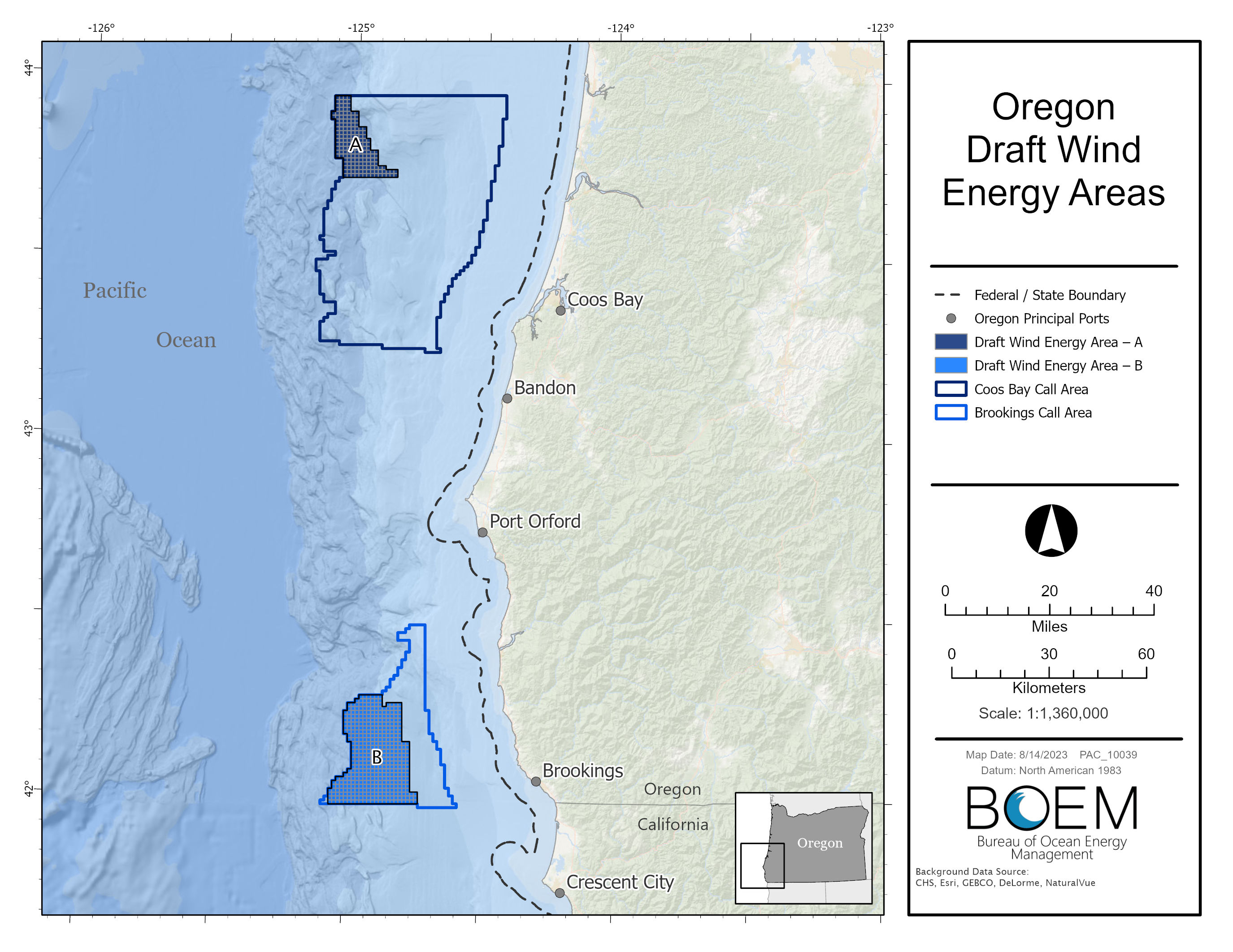
Draft Wind Energy Areas
On Aug.15, 2023, BOEM announced a 60-day public comment period on two draft Wind Energy Areas (WEAs) located in the existing Call Areas offshore southern Oregon. The draft WEAs cover approximately 219,568 acres offshore southern Oregon with their closest points ranging from approximately 18 – 32 miles off the coast.
BOEM used a comprehensive process to identify the draft WEAs as potential offshore locations that appear most suitable for floating offshore wind energy leasing and potential development, taking into consideration possible effects to local coastal and marine resources and ocean users. In addition to coordinating with the State of Oregon, BOEM collaborated with the National Oceanic and Atmospheric Administration’s National Centers for Coastal Ocean Science (NCCOS) to use an ocean planning model that seeks to identify and minimize conflicts.
- Final NCCOS Report: A Wind Energy Area Siting Analysis for the Oregon Call Areas (Feb. 2024)
- Draft NCCOS Report: A Wind Energy Area Siting Analysis for the Oregon Call Areas (Aug. 2023)
During the comment period, BOEM held an intergovernmental renewable energy task force meeting, an informational fishing webinar and in-person public meetings on the Oregon coast to discuss data used to inform the draft wind energy areas and next steps.
Virtual Oregon Intergovernmental Renewable Energy Task Force Meeting
Informational Fishing Webinar (fishing data focus):
- Agenda
- Thursday, September 21, 2023: 5:00 pm – 8:00 p.m.
In-person public open house meetings:
- VENUE CHANGE - Gold Beach, Oregon: Tuesday, September 26, 2023
Gold Beach Community Center
29841 Airport Way
4:00p.m. – 8:00 p.m.
- Coos Bay, Oregon: Wednesday, September 27, 2023
Coos Bay Public Library, Myrtlewood Room
525 Anderson Avenue
4:00p.m. – 8:00 p.m.
- Brookings, Oregon: Thursday, September 28, 2023
Southwest Oregon Community College - Curry Campus, Commons Room
96082 Lone Ranch Pkwy
4:00p.m. – 8:00 p.m.
BOEM accepted public comments at the in-person open house and virtual meetings. Comments received during the comment period informed designation of final WEAs for further analysis and review for possible offshore wind energy leasing. BOEM extended the comment period through 11:59 pm ET on October 31, 2023. To view comments on the draft WEAs please go to regulations.gov, docket number BOEM-2023-0033.
Draft Wind Energy Area Public Meeting Handouts
- BOEM Outreach Engagement fact sheet
- BOEM Visualization fact sheet
- NOAA NCCOS Fisheries Handout
- NOAA NCCOS Natural Resources Handout
- Selected BOEM Research Informing Oregon Renewable Energy
- Wind Energy Commercial Leasing Process
Maps
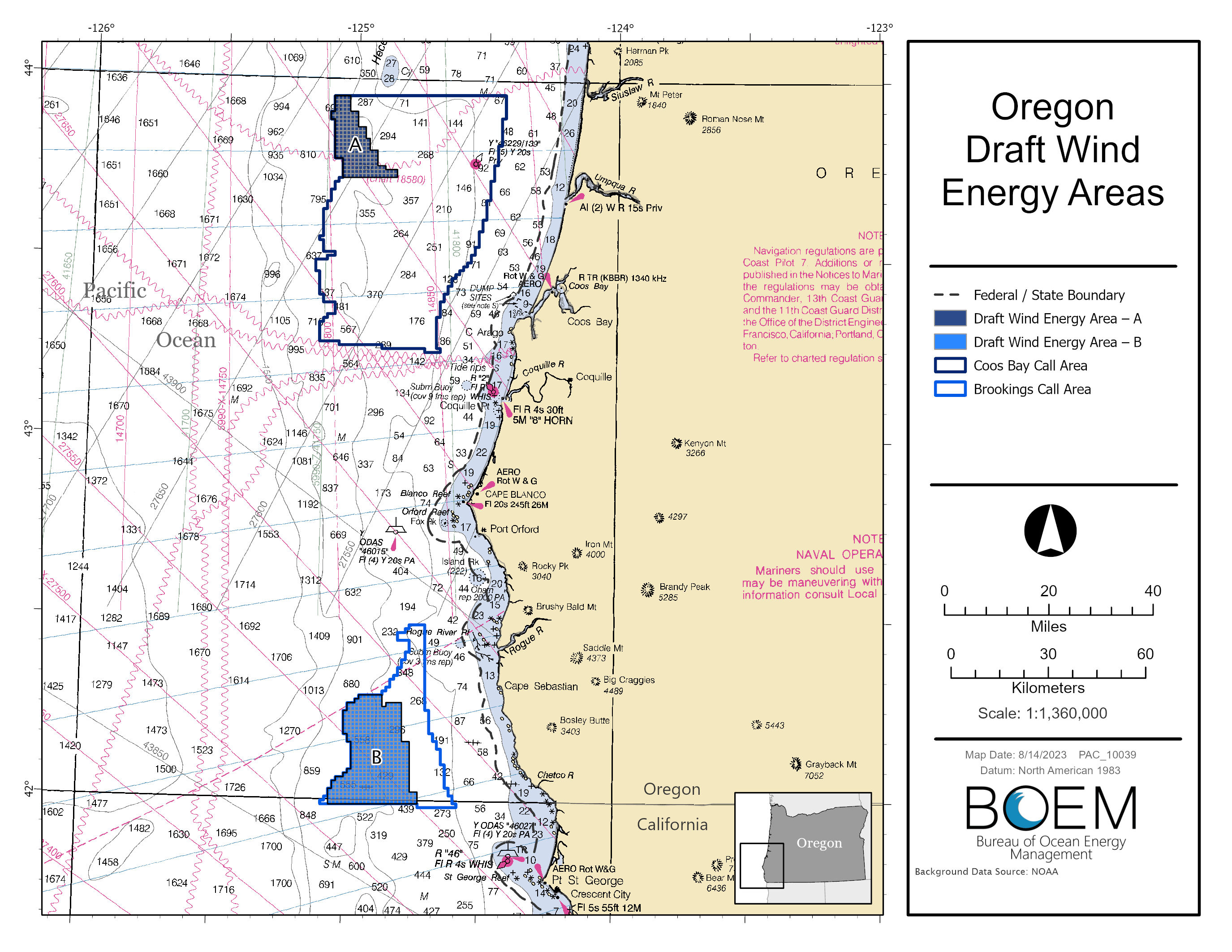
- Oregon Draft WEAs
- Oregon Draft WEAs Nautical Chart Map
- Oregon Draft WEAs Coordinates Map (hyperlink to attached map)
- Shapefiles
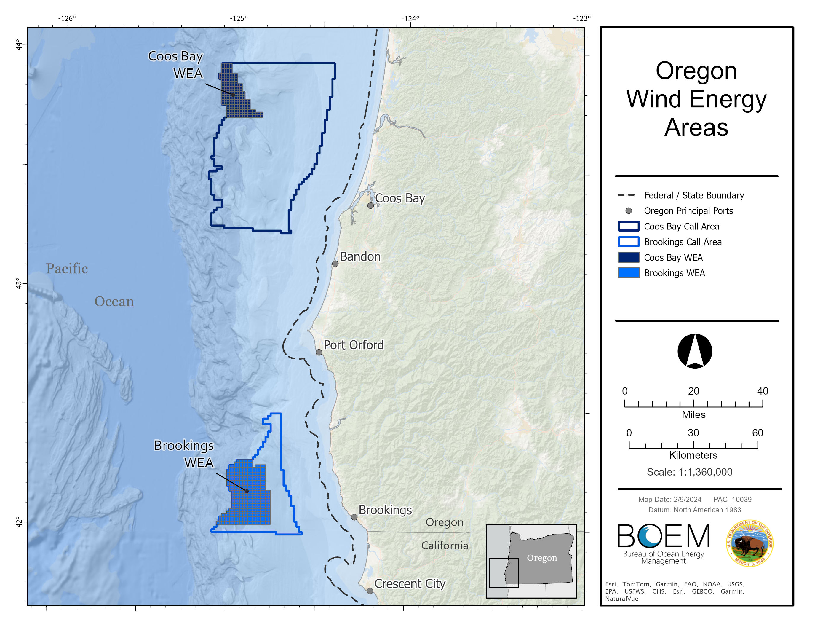
News Release: BOEM Finalizes Wind Energy Areas in Oregon
Oregon Wind Energy Areas
The proposed Brookings Wind Energy Area consists of 133,792 acres and is located approximately 18 miles from shore. The proposed Coos Bay Wind Energy Area consists of 61,203 acres and is located approximately 32 miles from shore. The Brookings WEA is 133,792 acres and approximately 18 mi off the coast. If fully developed, the Final WEAs could support 2.4 GW of energy production.
BOEM used a comprehensive process to identify the potential offshore locations that appear most suitable for floating offshore wind energy leasing and potential development, taking into consideration possible impacts to local coastal and marine resources and ocean users. BOEM coordinated with the State of Oregon and collaborated with the National Oceanic and Atmospheric Administration’s National Centers for Coastal Ocean Science (NCCOS) to use an ocean planning model that seeks to identify and minimize conflicts.
- Oregon Wind Energy Area Identification Memo
- Notice of Intent to prepare an Environmental Assessment for commercial wind lease issuance and site assessment activities on the Pacific Outer Continental Shelf Offshore Oregon – How to comment on the scoping period
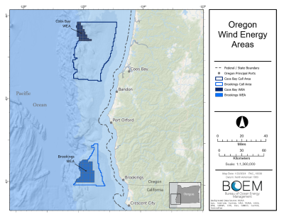
Maps
Call for Information and Nominations
Oregon Call for Information and Nominations
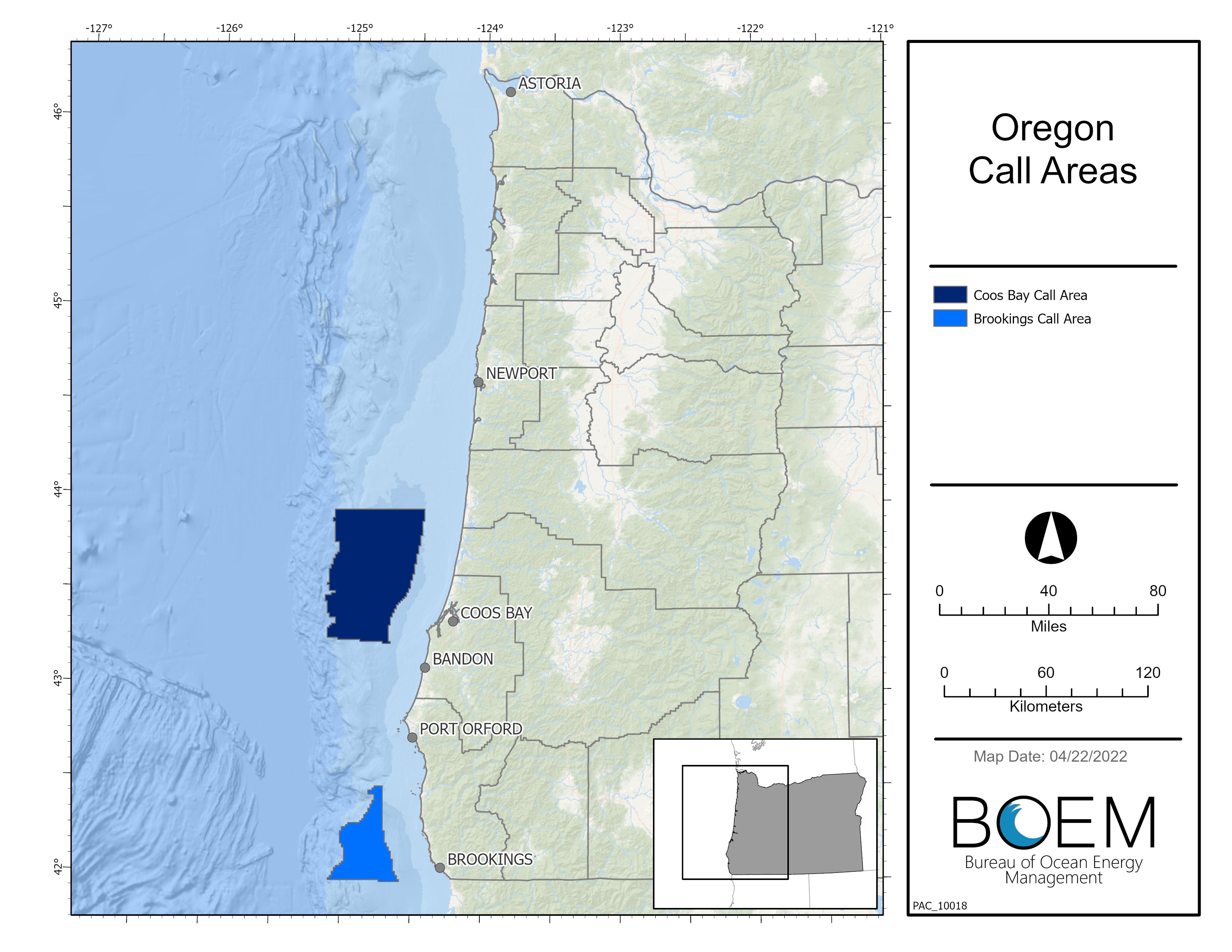
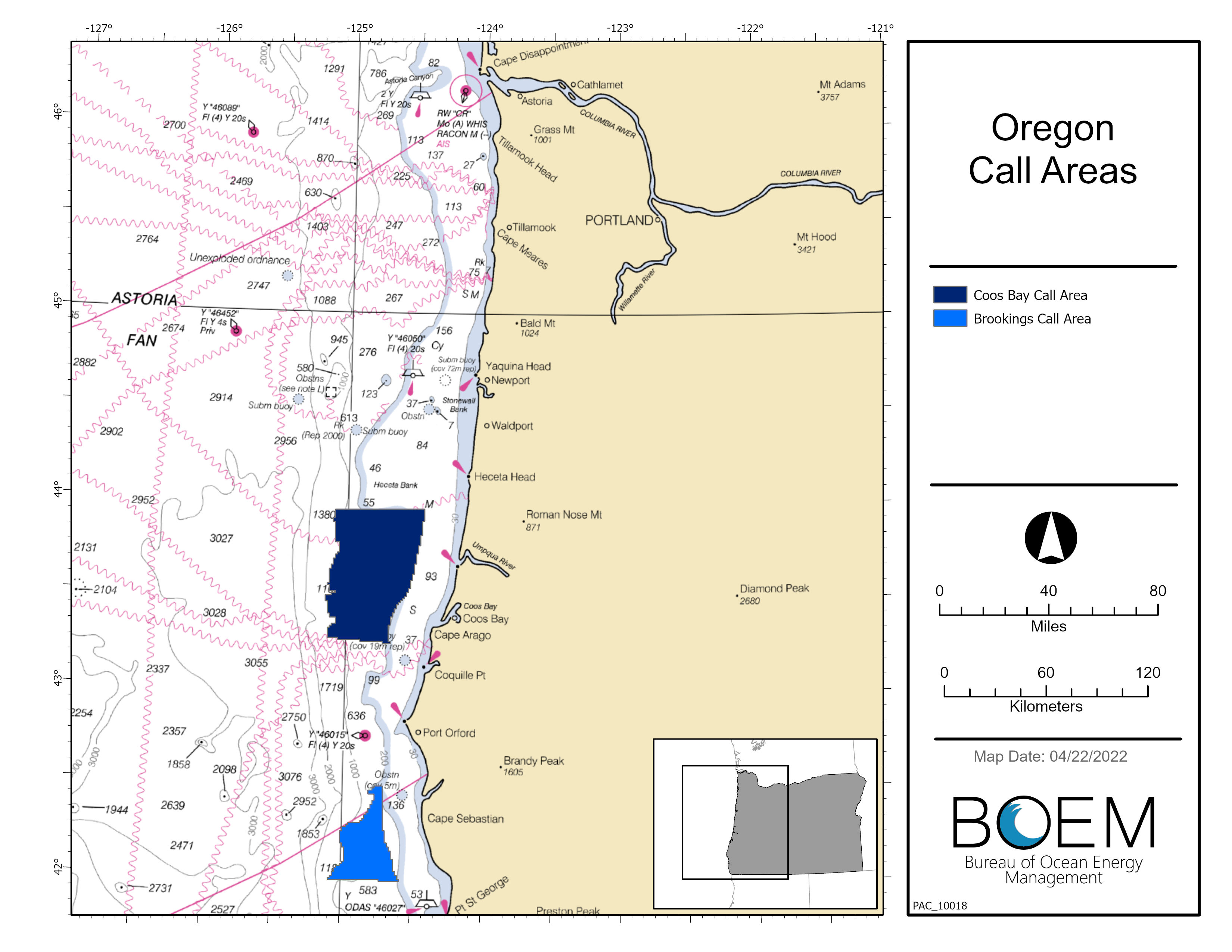
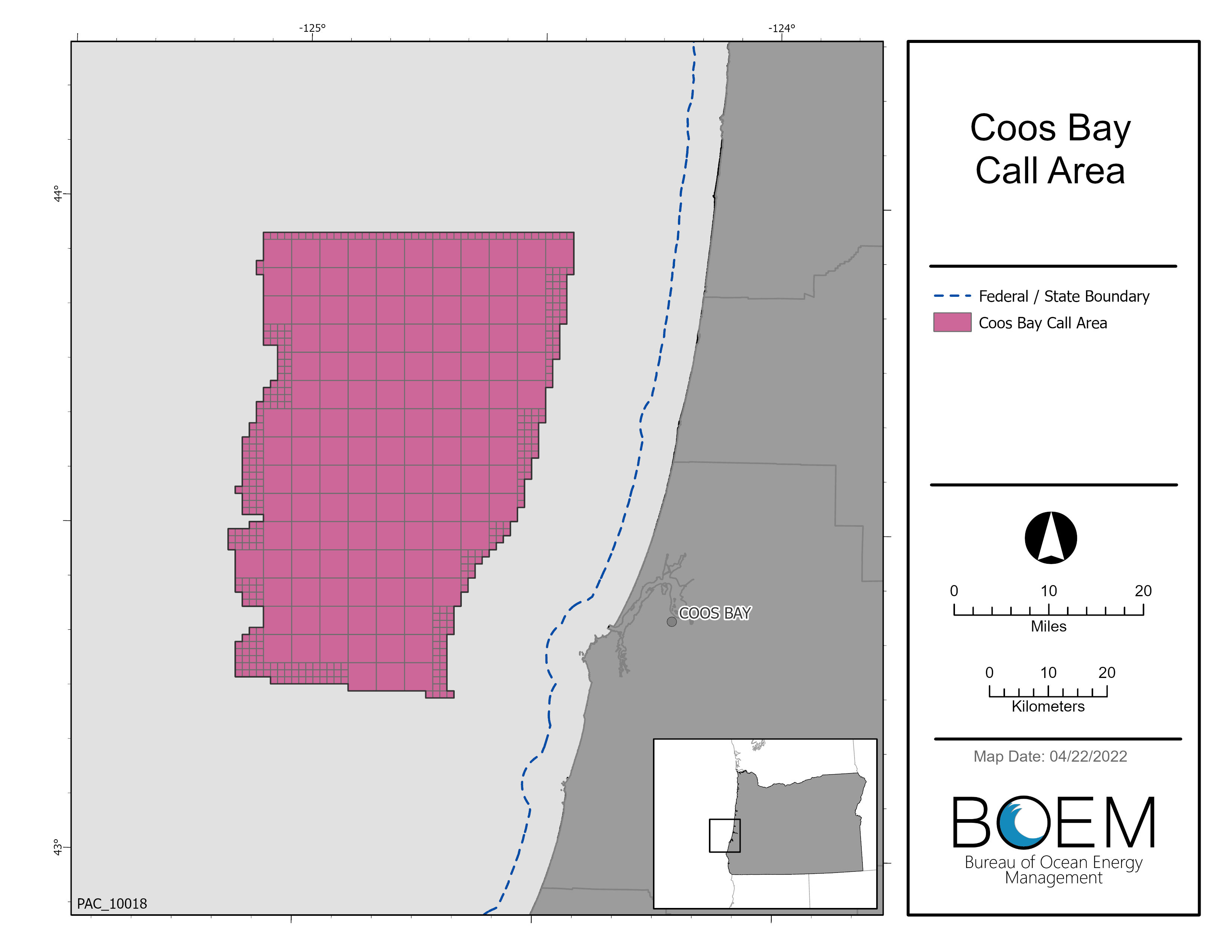
The Call Area is located offshore the State of Oregon and comprises areas identified as Coos Bay and Brookings. These two areas total about 1,159,298 acres (1,811 square miles) and are located offshore south-central and southern Oregon, respectively.
- Coos Bay Call Area: The boundary of the Coos Bay Call Area begins 13.8 miles offshore Charleston, Oregon, and extends to about 65 miles offshore. The eastern boundary water depth ranges from about 394 to 722 feet (120 to 220 meters). The area is about 67 miles in length from north to south and about 41 miles in width from east to west. The entire area is approximately 872,854 acres (1,364 square miles).
- Brookings Call Area: The boundary of the Brookings Call area begins 13.8 miles offshore Gold Beach and Brookings, Oregon, and extends to about 46 miles offshore. The eastern boundary water depth ranges from about 410 to 1,115 feet (125 to 340 meters). The area is about 46 miles in length from north to south and about 22 miles in width from east to west. The entire area is approximately 286,444 acres (448 square miles).
Maps of Oregon Call Areas
- Oregon Call Areas Map, (NOAA Chart), (Shapefile) and Waypoints (Excel, Shapefile)
In response to the Call, BOEM received nominations of areas of interest from 4 developers. Each of the parties listed below has been legally, technically and financially qualified.
- Map of all Nominations Received
- Avangrid Renewables LLC
- BlueFloat Energy Oregon LLC
- OW North America Ventures LLC
- US Mainstream Renewable Power Inc
Related Announcements
- BOEM Enhances its Processes to Identify Future Offshore Wind Energy Areas (09/16/2022)
- Biden-Harris Administration Advances Offshore Wind Energy Leasing on Atlantic and Pacific Coasts | U.S. Department of the Interior (doi.gov) (04/27/2022)
- You're Invited: BOEM Oregon Intergovernmental Renewable Energy Task Force Meeting and Joint Pacific Fishery Management Council-BOEM Meeting (02/17/2022)
- You're Invited: BOEM Oregon Intergovernmental Renewable Energy Task Force Meeting (10/01/2021)
- Secretary Haaland Outlines Ambitious Offshore Wind Leasing Strategy | U.S. Department of the Interior (doi.gov) (10/13/2021)
- You’re Invited: Offshore Wind Energy Planning Data Review Workshops (07/21/2021)
- BOEM and the State of Oregon Host Virtual Informational Meetings on Offshore Wind Energy Planning (05/06/2021)
- RESCHEDULED DATE AND TIME BOEM OROWindMap Webinar (01/13/2021)
- REMINDER: Webinar Series to Share Information on Research Related to Renewable Energy off the U.S. West Coast (06/29/2020)
- You're Invited: BOEM Oregon Intergovernmental Renewable Energy Task Force Meeting (05/21/2020)
- REMINDER: Webinar Series to Share Information on Research Related to Renewable Energy off the U.S. West Coast (05/05/2020)
- REMINDER: Webinar Series to Share Information on Research Related to Renewable Energy off the U.S. West Coast (03/03/2020)
- Webinar Series to Share Information on Research Related to Renewable Energy off the U.S. West Coast (11/05/2019)
- You're Invited: BOEM Oregon Intergovernmental Renewable Energy Task Force Meeting (08/22/2019)
- A Message from BOEM's Acting Director: The Path Forward for Offshore Wind Leasing on the Outer Continental Shelf (06/11/2019)
- New Guide Available To Help Government Agencies And Tribes Identify Places Of Importance Along The West Coast (04/26/2016)
- Now Available: Pacific Regional Ocean Uses Report, Atlas Maps, And Data (12/21/2015)
- Milestone Cleared For First Marine Hydrokinetic Research Lease Offshore The West Coast (06/19/2014)
- BOEM Issues First Renewable Energy Lease For Marine Hydrokinetic Technology Testing (06/03/2014)
- BOEM To Conduct Environmental Review Of Renewable Energy Demonstration Project Offshore Oregon (05/28/2014)
- BOEM To Assess Competitive Interest In Site Of Proposed Wave Energy Test Center Offshore Oregon (03/21/2014)
- Secretary Jewell Announces Key Step Forward For Offshore Wind Project In Oregon (02/05/2014)
- BOEM To Assess Competitive Interest In First Proposed Wind Energy Project Site Offshore West Coast (09/27/2013)
- Secretary Salazar: Renewable Energy On Public Lands And Waters Making Rapid Advances (02/26/2013)
- BOEM And FERC Revise Guidelines For Development Of Wave Energy And Ocean Current Technologies In U.S. Waters (07/19/2012)
- BOEMRE and Oregon Form Offshore Renewable Energy Task Force (03-31-2011)
Engagement Opportunities
Oregon Draft Environmental Assessment Virtual Public Meeting (May 21, 2024)
- Agenda
- Meeting Slides
- Meeting Summary
- Meeting Attendance List
- Meeting Recording
Oregon Intergovernmental Renewable Energy Task Force meeting (May 23, 2024)
Oregon Proposed Sale Notice Fisheries Meeting (May 29, 2024)
- Agenda
- Presentation
- Meeting Recording
Oregon Proposed Sale Notice Public Meeting (May 30, 2024)
- Agenda
- Presentation
- Meeting Recording
Oregon Draft Environmental Assessment Virtual Public Meeting (June 5, 2024)
- Agenda
- Meeting Slides
- Meeting Summary
- Meeting Attendance List
- Meeting Recording
Oregon Auction Seminar (June 12, 2024)
Additional Engagement:
PacWave South
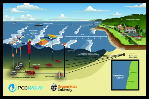
On February 16, 2021, BOEM issued a lease to Oregon State University for the PacWave South Project, the First Wave Energy Research Project in Federal Waters Offshore the U.S. West Coast.
The Federal marine hydrokinetic energy (MHK) research lease was issued to Oregon State University (OSU) for the PacWave South project, a proposed open ocean wave energy test center, to be located approximately six nautical miles off Newport, Oregon. The research lease area is approximately 4,270 acres (6.67 square miles) for a proposed 2.65 square mile-project. Lease issuance by BOEM is a prerequisite for a license from Federal Energy Regulatory Commission (FERC), which is the Federal Agency that would approve project construction and operations.
On March 5, 2024, BOEM issued a lease amendment for the OSU PacWave South Project, adjusting the easements for cable routing between the lease area and shoreline.
Background
OSU submitted an unsolicited request for a research lease for the PacWave South Project, formerly known as the Pacific Marine Energy Center – South Energy Test Site (PMEC-SETS) Project, in October 2013. The project would consist of four test ‘berths’ to support the testing of up to 20 wave energy devices, with an installed capacity not to exceed 20 megawatts, to demonstrate the viability of wave energy.
- Project Map (2013)
- Project Map on Nautical Chart (2013)
- Aliquots from 2013 Request (Zip File)
- Lease P OCS-0560 Map (2021)
- Lease P OCS-0560 Aliquots (2021) (Zip File)
In March 2014, BOEM published a Request for Competitive Interest in the Federal Register. Comments were submitted in response to the request. June 2014, BOEM published a Determination of No Competitive Interest in the area requested by Oregon State University and proceeded with the leasing process on a non-competitive basis.
Jurisdiction for grid-connected marine hydrokinetic (MHK) projects on the Outer Continental Shelf (OCS) is shared by BOEM and the Federal Energy Regulatory Commission (FERC). BOEM has authority to issue leases, easements, and rights-of way and FERC has authority for the construction and operations of MHK projects on the OCS. Visit BOEM’s Regulatory Framework and Guidelines for more information on the regulatory process.
In June 2014, FERC published a Notice of Intent to File License Application and OSU’s request to use the Alternative Licensing Process was approved. Additionally, OSU filed a Pre-Application Document (PAD). OSU submitted the Final License Application to FERC in May 2019. In July 2019, OSU amended the lease request area to include the Aliquots encompassed by the project site, as detailed in the Final License Application to FERC. On August 29, 2019, FERC published a notice which (1) accepted the application for filing and (2) solicits anyone, over a 30-day window, to submit comments, a motion to intervene and protest, final terms and conditions, recommendations, and prescriptions.
On April 23, 2020, FERC issued the Environmental Assessment for the PacWave South Project along with a Notice of Availability which includes a 45-day comment period for the Environmental Assessment. BOEM's proposed action is to issue a research lease and easements for five subsea transmission cables on the OCS.
On January 19, 2020, BOEM offered the first marine renewable energy research lease in Federal waters off the U.S. West Coast.
On January 19, 2021, BOEM issued the Finding of No Significant Impact for the MHK research lease based on the analysis in the Environmental Assessment and offered an MHK research lease to OSU for the PacWave South Project.
February 16, 2021 – BOEM Issues lease to OSU for the PacWave South Project
March 1, 2021 - FERC issues license order to OSU for the PacWave South Hydrokinetic Project No. 14616
July 28, 2021 – BOEM publishes public notice to inform of lease issuance and to define the size of lease area.
Additional information related to OSU’s licensing with FERC can be found at FERC’s website (use the “eLibrary” link and P-14616 for the “Docket Number”).
WindFloat Pacific
In September 2018, BOEM determined that the Principle Power Offshore Wind Pilot project no longer retains its non-competitive interest status and BOEM is no longer processing the Principle Power lease request. The Offshore Wind Pilot Project was proposed by Principle Power, Inc., in May 2013
- WindFloat Pacific Project Determination of No Competitive Interest Federal Register Notice
- WindFloat Pacific Project Request for Interest Federal Register Notice
- Comments Submitted in Response to Request for Interest
- WindFloat Pacific Project Unsolicited Lease Request
- WindFloat Pacific Project Map
- WindFloat Pacific Project Map on Nautical Chart
Environmental Review for WindFloat Pacific
- Notice of Intent to Prepare an Environmental Assessment for Proposed Wind Energy-Related Development Activities on the Pacific Outer Continental Shelf (OCS) Offshore Oregon and Notice of Public Scoping Meetings
- Public Scoping meeting materials and posters (06/17/14, Coos Bay, OR)
- Public Scoping Comments Received
- Fishing Outreach Meeting: June 18, 2014 - Charleston, OR
WindFloat Pacific Data Files
Resources
- Pacific Regional Collaboration - Learn more about BOEM's involvement in the West Coast Ocean Alliance and West Coast Ocean Data Network
- Selected BOEM-Funded Research Informing Renewable Energy Offshore Oregon
- Fact Sheet: BOEM Renewable Energy Program
- Fact Sheet: BOEM Leasing Process
- Overview of Floating Offshore Wind – National Renewable Energy Laboratory
- Offshore Wind Market Report: 2021 Edition – Department of Energy, Energy Efficiency & Renewable Energy
- Tips on how to provide helpful comments
BOEM-Oregon Offshore Wind Energy Planning
- Data Gathering and Engagement Plan for Offshore Wind Energy in Oregon
- Oregon Offshore Wind Mapping Tool (OROWindMap)
- OROWindMap Catalog
- Wind Energy Area Siting Analysis for the Oregon Call Areas
- Fact Sheet: Oregon Offshore Renewable Energy
- Fact Sheet: OROWindMap
- Handout: Oregon Fishing Effort Datasets
Draft Wind Energy Area Public Meeting Handouts
- BOEM Outreach Engagement fact sheet
- BOEM Visualization fact sheet
- NOAA NCCOS Fisheries Handout
- NOAA NCCOS Natural Resources Handout
- Selected BOEM Research Informing Oregon Renewable Energy
- Wind Energy Commercial Leasing Process
Oregon related news releases and Notes to Stakeholders can be found in the BOEM Newsroom. In the search bar, type the name of the state and/or select year of announcement.