
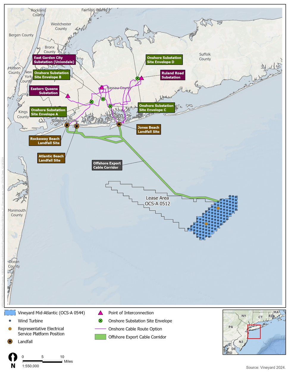
- Project Overview
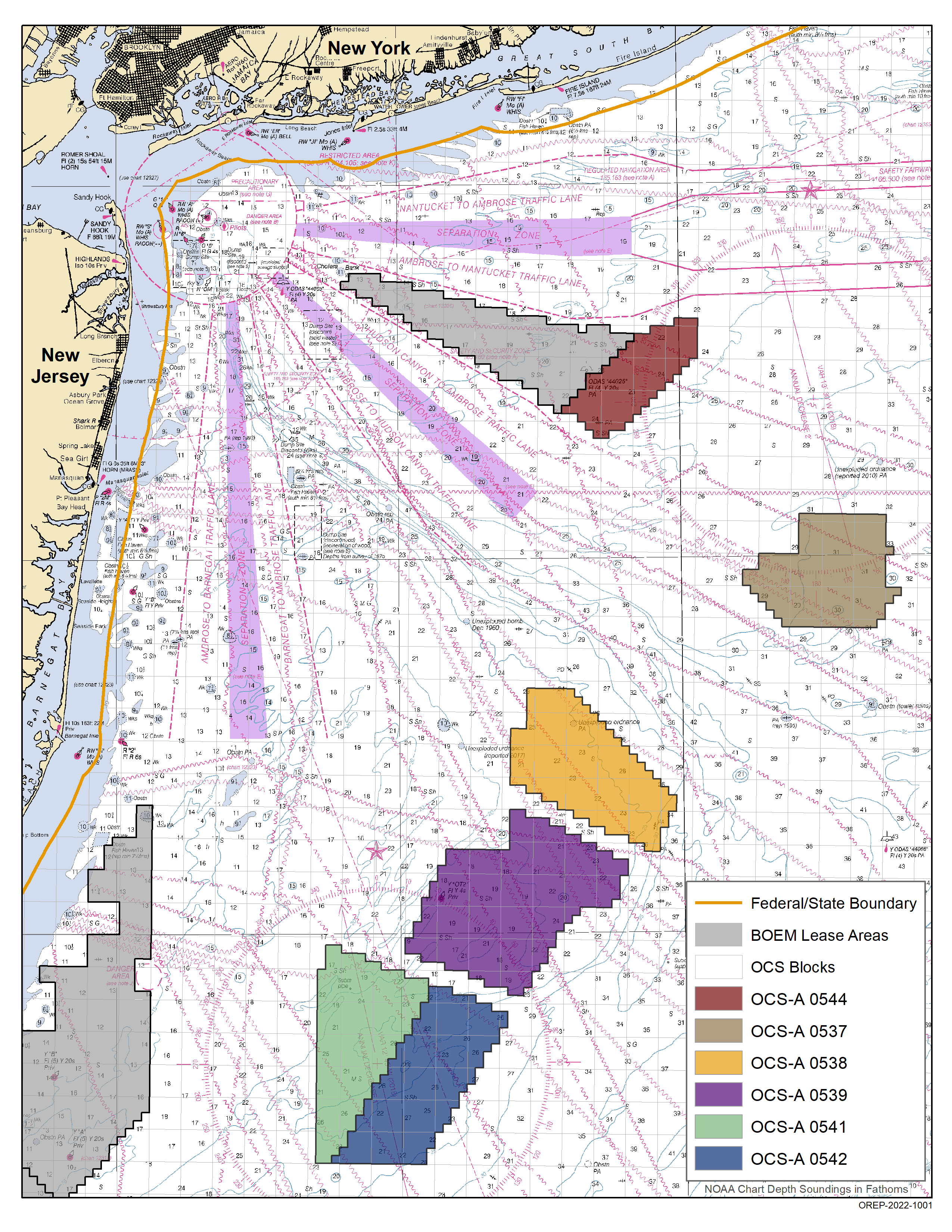
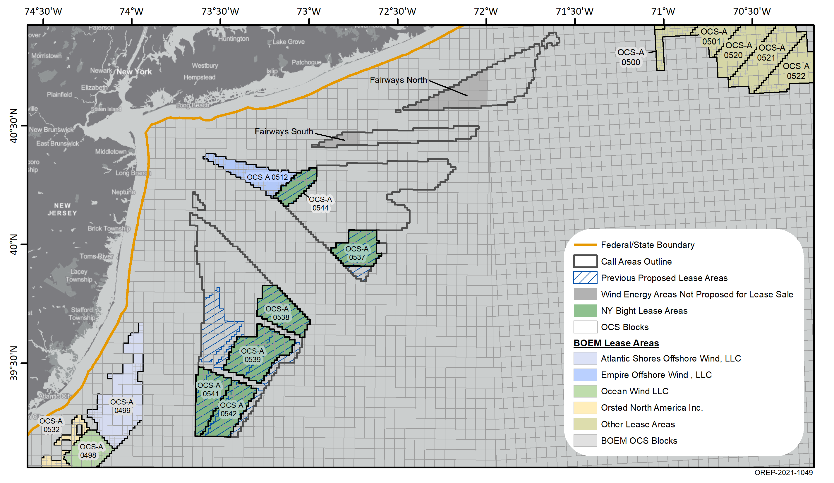
- Lease Area Descriptions
- Visual Impact Assessment
- Leasing History
- Environmental Review
What's New?
On Jan. 15, 2025, the Bureau of Ocean Energy Management (BOEM) published a Notice of Intent (NOI) in the Federal Register to prepare an Environmental Impact Statement (EIS) for a Construction and Operations Plan submitted by Vineyard Mid-Atlantic, LLC. The publication of the NOI opened a 45-day public comment period.
The Department of the Interior and BOEM are implementing President Trump’s memorandum temporarily halting offshore wind leasing on the Outer Continental Shelf. The memorandum also pauses new or renewed approvals, rights-of-way, permits, leases, or loans for offshore wind projects pending a review of federal wind leasing and permitting practices.
As a result, the February virtual public meetings on BOEM’s NOI to prepare an EIS for the proposed Vineyard Mid-Atlantic Project have been cancelled.
For those who intended to provide public comment, written comments can still be submitted at www.regulations.gov under Docket No. BOEM-2025-0002 until the public comment period closes on March 3rd, 2025.
For more information, visit the Vineyard Mid-Atlantic web page.
Background
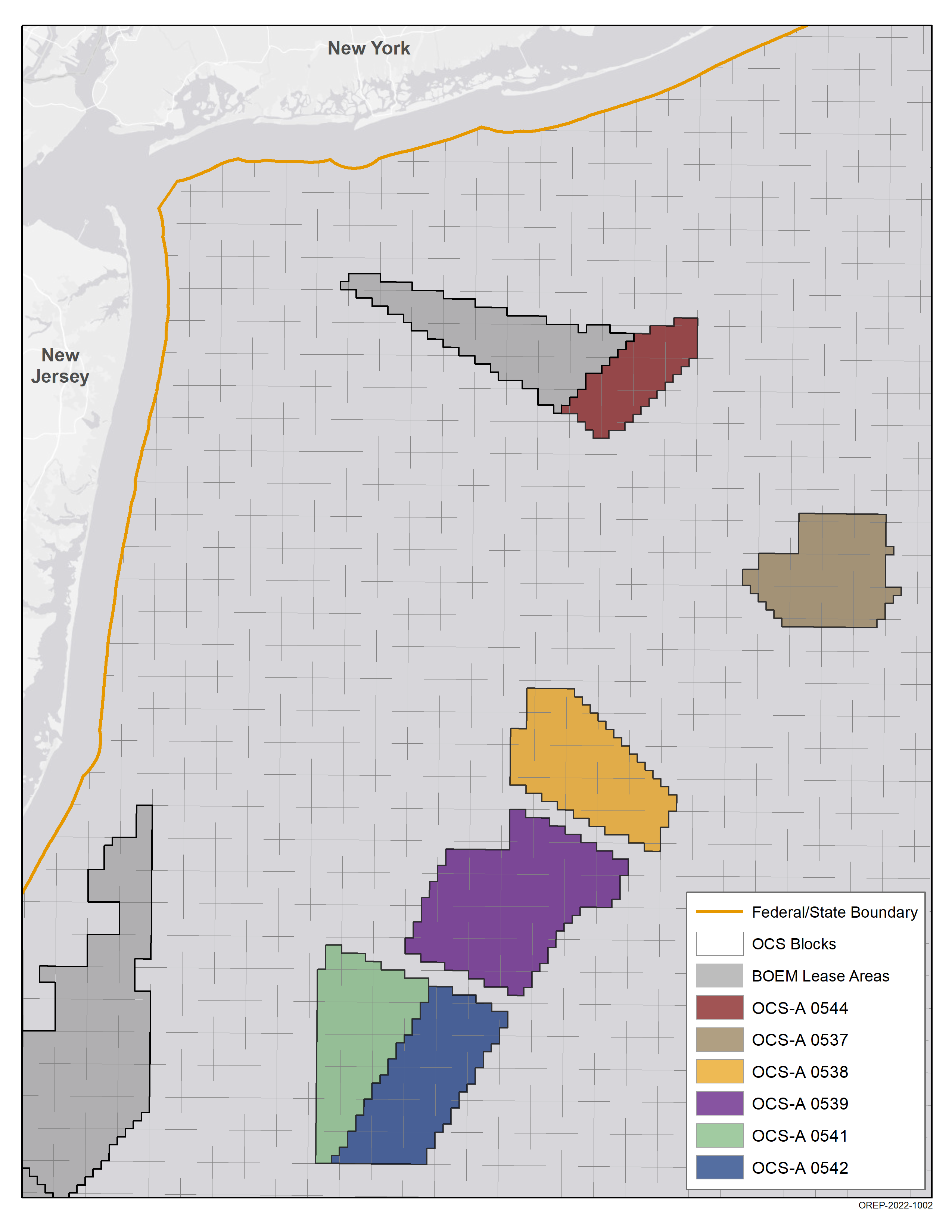
There are six leases in the New York Bight.
- Bluepoint Wind, LLC (OCS-A 0537)
- Attentive Energy LLC (OCS-A 0538)
- Community Offshore Wind, LLC (OCS-A 0539)
- Atlantic Shores Offshore Wind Bight, LLC (OCS-A 0541)
- Invenergy Wind Offshore LLC (OCS-A 0542)
- Vineyard Mid-Atlantic LLC (OCS-A 0544)
Record of Decision
On Dec. 2, 2024, BOEM announced the availability of a Record of Decision (ROD) identifying 58 environmental measures expected to be applied to projects proposed in the six New York Bight lease areas offshore New York and New Jersey. This ROD does not approve any activities, nor does it preclude additional, different, or revised measures from being considered during project-specific environmental reviews. If projects are approved, BOEM estimates that full development of the six lease areas could generate up to 7 GW of offshore wind energy, enough to power up to two million homes.
The following documents are available for your viewing.
New York Bight Section 106 Programmatic Agreement
New York Bight Final Sale Notice Lease Area Descriptive Statistics
The following table contains a custom OceanReport and a description of each New York Bight lease area.
Lease | OCS-A 0537 | OCS-A 0538 | OCS-A 0539 | OCS-A 0541 | OCS-A 0542 | OCS-A 0544 | Total |
Lessee | Bluepoint Wind, LLC | Attentive Energy LLC | Community Offshore Wind, LLC | Atlantic Shores Offshore Wind Bight, LLC | Invenergy Wind Offshore, LLC | Vineyard Mid-Atlantic, LLC | -- |
| Ocean Reports[1] | Ocean Report | Ocean Report | Ocean Report | Ocean Report | Ocean Report | Ocean Report | -- |
Acres | 71,522 | 84,332 | 125,964 | 79,351 | 83,976 | 43,056 | 488,201 |
Developable acres[2] | 71,522 | 79,438 | 114,277 | 76,139 | 76,894 | 43,056 | 461,326 |
Installation Capacity (MW)[3] | 868 | 964 | 1,387 | 924 | 934 | 523 | 5,601 |
Homes powered[4] | 303,911 | 337,548 | 485,586 | 323,530 | 326,738 | 182,954 | 1,960,268 |
Power production (MWh/yr)[5] | 3,042,588 | 3,379,340 | 4,861,411 | 3,238,998 | 3,271,116 | 1,831,628 | 19,625,081 |
Max depth (meters[m]) | 61 | 63 | 51 | 51 | 54 | 46 | -- |
Min depth (m) | 50 | 37 | 31 | 31 | 32 | 40 | -- |
Closest distance to NY (nautical mile [nmi]) | 38 | 47 | 56 | 65 | 69 | 20 | -- |
Closest distance to NJ (nmi) | 53 | 36 | 32 | 27 | 35 | 36 | -- |
[1] OceanReports were generated on September 22, 2022.
[2]Developable area accounts for any “no surface occupancy” area in the lease which prohibits permanent placement of an object, such as a wind turbine, on the ocean surface.
[3] Energy capacity is based on a conservative power density of 3 MW/kilometers2. BOEM acknowledges that as offshore wind technology improves the projects proposed in the lease areas may have a greater installation capacity.
[4] Number of homes powered is based upon 350 homes per MW.
[5] Power production formula is Capacity (MW) * 8760 (hours/year) * 0.4 (capacity factor).
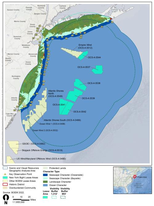
Visual Impact Assessment
The New York Bight Offshore Wind Seascape, Landscape, Visual Impact Assessment (SLVIA) can be accessed using the links below.
- SLVIA Report
- Appendices (See below for Appendix E: Visual Simulations)
The visual impact assessment includes photo simulations for the six New York Bight lease areas from numerous Key Observation Points (KOPs) and provides an analysis of the approximated visibility of potential development. The photo simulations show current conditions and illustrate potential changes to the ocean character and views from onshore locations. In addition, simulations illustrate cumulative visual effects by the six New York Bight leases plus non-New York Bight leases that are currently under review or have been approved that are located within the PEIS affected viewshed, and simulations that show only the non-New York Bight leases within the PEIS affected viewshed.
The PEIS simulations predate leaseholders submitting their respective Construction and Operations Plans (COPs). The simulations use two representative project scenario heights for the wind turbine hub and tip of blade and the same wind turbine spacing for the analysis. A wind turbine tip of blade height of 1,312 feet was used to represent a maximum impact scenario, and a wind turbine tip of blade height of 853 feet was used to represent a feasible impact scenario based on the tallest wind turbine commercially available today. COPs for the six lease areas are likely to propose using wind turbine at heights below the 1,312 feet in height.
Of the 32 KOPs, 17 were selected for visual simulations and are presented below.
The Final Programmatic EIS Appendix H – Seascape, Landscape, and Visual Impact Assessment references the photo simulations and may be downloaded here, or from the following links for the photo-simulations only.
BOEM recommends viewing the simulations in accordance with the instructions below for viewing printed photos or on-screen viewing to fully understand the overall horizontal and vertical size and scale of the development represented in the photo simulations. Each simulation contains instructions for viewing with a scaling bar. Once the scale is set, it is likely that the simulation will be larger than the monitor’s screen, which will require using the panning tool for the viewer to pan across the screen to see the full scope of the affected view.
Photo simulations are presented in two formats: panoramic photo format, which approximates the human-field-of-view, and single frame photo format equivalent to a photo taken with a 50 mm lens on a 35 mm full-frame camera, which represents the “normal” camera lens field-of-view. Each format set has a purpose.
The panoramic photo format approximates the human field-of-view and illustrates the horizontal breadth a person may see when standing at the location and looking in the direction the photo was taken. This photo informs the viewer how much of horizontal span of view would be occupied by the project without moving the head from side to side. However, the panoramic photo simulation does not properly illustrate the vertical size and scale of the wind turbines and other offshore facilities associated with the wind energy development.
The single frame photo series in the simulations are cropped equivalents of a photo taken with a 50 mm lens on a 35 mm full-frame camera approximates the size and scale of the project’s offshore wind turbines and other associated offshore facilities at the photo-point location. However, the horizontal field-of-view in the single frame is considerably less than the human field-of-view.
Photo simulations of the six NY Bight lease areas from select KOPs (Figure 1) may be viewed or downloaded using the links below. For the most accurate viewing, we recommend using zoom to Fit the Window for the 124 degree panoramas and zoom to 100% for the 50 mm cropped equivalent photo simulations.
New York Bight Photo-Simulations by KOP from North to South
- KOP 30: Shinnecock Inlet
- KOP 31: Westhampton Beach
- KOP 39: Empire State Building
- KOP 37: Point O’ Woods
- KOP 32: Fire Island Lighthouse-Upper Deck
- KOP 40: Robert Moses Field 5 – nighttime
- KOP 28: Jones Beach
- KOP 26: Fort Tilden
- KOP 35: Twin Lights Lighthouse
- KOP 18: Allenhurst Residential Historic District
- KOP 36: Asbury Park Hall-Top
- KOP 13: Mantoloking
- KOP 10: Barnegat Lighthouse
- KOP 08 - A: Beach Haven (day)
- KOP 08 - B: Beach Haven (night)
- KOP 05: Jim Whelan Hall-Balcony
- KOP 04: John Stafford Hall-Beach Entrance
- KOP 02: Lucy the Elephant
In addition to the photo simulations described above, 360° surround view simulations were produced from KOPs. The 360° surround view simulations enable the onscreen viewer to pan from left to right as if they are standing at the KOP and looking full circle to see the entire physical context of the KOP location and its orientation to the ocean view. These cannot be downloaded, but may be viewed on the screen at: https://ny-bight.truescape.com/1.2.0/index.html#/
Unsolicited Lease Request Offshore New York
On December 30, 2016, PNE Wind USA, Inc. submitted an unsolicited lease request for 40,920 acres offshore New York.
- PNE Wind USA, Inc. unsolicited request for an area offshore New York
- Shapefile for the unsolicited lease request
Call for Information and Nominations
BOEM published a Call for Information and Nominations (Call) on April 11, 2018 to obtain nominations from companies interested in commercial wind energy leases within the proposed area in the New York Bight. This region represents an area of shallow waters between Long Island (to the north and east) and the New Jersey coast (to the south and west).
- In addition to nominations, BOEM gathered public input on the potential for wind energy development in the Call Area. The comment period closed on July 30, 2018. All comments are available on https://www.regulations.gov.
- New York Bight - Call for Information and Nominations
- Map Showing the New York Bight Call for Information and Nominations Areas
- GIS File of the New York Bight Call for Information and Nominations Areas
- Nominations
View the NY Bight Call Area in the Northeast Ocean Data Portal.
Public Engagement
- Apr. 2021 Intergovernmental Renewable Energy Task Force Meeting on the New York Bight
- Nov. 2018 Intergovernmental Renewable Energy Task Force Meeting on the New York Bight
- May 2018 Intergovernmental Renewable Energy Task Force Meeting on the New York Bight
- 2017 New York Bight Intergovernmental Renewable Energy Task Force Webinar
More information can be found on the New York Activities page: https://www.boem.gov/renewable-energy/state-activities/new-york-activities
Wind Energy Areas
In March 2021, BOEM identified nearly 800,000 acres as Wind Energy Areas (WEAs) in the New York Bight, between Long Island and the New Jersey coast. The agency initiated an environmental review, with public input, on these areas in federal waters for potential offshore wind leasing.
The goal of BOEM’s Area Identification process is to identify the offshore locations that appear most suitable for wind energy development taking into consideration coexistence with ocean users. As part of this process, BOEM removed areas of highest conflict from consideration. BOEM received input from the public and other governmental agencies through the Call for Information and task force meetings as part of the process. The New York Bight WEAs are located in an area of shallow waters between Long Island (to the north and east) and the New Jersey coast (to the south and west).
- Memorandum for Area ID in the NY Bight
- New York Bight Wind Energy Areas Summary
- Wind Energy Area Shape Files
Department of Defense (DoD) Assessment
DoD’s Military Aviation and Installation Assurance Siting Clearinghouse (Clearinghouse) has been leading DoD’s review of the New York Bight Wind Energy Areas in support of BOEM’s efforts to deconflict the area. In June 2021, the Clearinghouse provided an update to their December 15, 2020 assessment by providing feedback on lease areas proposed in the Hudson South Wind Energy Area. In summary, the Clearinghouse has refined its analysis and indicated that a majority of the area that was initially designated as incompatible for wind energy development could be suitable for development with site-specific stipulations. A more complete summary of the updated assessment can be found on our website here: www.boem.gov/renewable-energy/state-activities/ny-bight-dod.
Proposed Sale Notice
BOEM published a Proposed Sale Notice (PSN) in the Federal Register on June 14, 2021. It provides detailed information about potential areas that could be available for leasing, proposed lease provisions and conditions, auction details (e.g., criteria for evaluating competing bids and award procedures), and lease execution. The proposal included up to eight lease areas in the New York Bight for potential commercial wind energy development. The lease areas have the potential to unlock over 7 gigawatts of offshore wind energy, powering over 2.6 million homes and supporting thousands of new jobs.
The comments received in response to this notice can be found here: https://www.regulations.gov/search/comment?filter=boem-2021-0033
Final Sale Notice and Shared Vision for the New York Bight
On Jan. 12, 2022, Secretary of the Interior Deb Haaland announced that BOEM would hold a wind energy auction on Feb. 23, 2022, in the New York Bight.
Secretary Haaland was joined by New Jersey Governor Phil Murphy and New York Governor Kathy Hochul to outline their shared vision for developing a robust offshore wind domestic supply chain that will deliver benefits to residents of New York and New Jersey and the surrounding region, including underserved communities. This collaboration will serve as a model for future engagement and establish the U.S. as a major player in the global offshore wind market.
- New York Bight Final Sale Notice
- A Shared Vision on the Development of an Offshore Wind Supply Chain
- New York Bight Final Sale Notice Decision Memorandum
- New York Bight Final Sale Notice Response to Comments
- Bidders Financial Form
- EFT Payment Instructions
- NY Bight Auction System Technical Supplement
- Maps
Commercial Leases
On Feb. 23, 2022, BOEM held an offshore wind auction for six lease areas in the New York Bight. The lease sale drew competitive winning bids from six companies totaling approximately $4.37 billion. For up-to-date leasing information, including the original lease and any lease amendments that may have occurred since initial lease execution, visit the Lease and Grant Information page.
New York Bight NOI Environmental Assessment
On Mar. 29, 2021, BOEM released a Notice to Stakeholders (NTS) announcing its intent to prepare an Environmental Assessment (EA) to consider the potential environmental consequences of site characterization activities (i.e., biological, archeological, geological, and geophysical surveys and core samples) and site assessment activities (i.e., installation of meteorological buoys) associated with issuing commercial and research wind energy leases in the WEAs, project easements associated with each lease issued, and grants for subsea cable corridors in the New York Bight. BOEM received approximately 3,000 comment letters during the 30-day scoping period (Docket number BOEM-2021-0021), which are available at https://www.regulations.gov/document/BOEM-2021-0021-0002/comment.
New York Bight Draft Environmental Assessment
On Aug. 10, 2021, the Bureau of Ocean Energy Management announced the availability of a draft environmental assessment (EA) that assesses the potential impacts of the issuance of commercial and research leases within the identified wind energy areas (WEAs) of the New York Bight, and granting of rights-of-way and rights-of-use and easement in the region.
- Notice to Stakeholders (NTS) of Availability of New York Bight Draft EA
- Draft EA and Appendices: Commercial and Research Wind Lease and Grant Issuance and Site Assessment Activities on the Atlantic Outer Continental Shelf of the New York Bight
- Notice to Stakeholders (NTS) of Extension of the Comment Period for New York Bight Draft EA
The availability of this EA initiated a 30-day public comment period. The public comment period was subsequently extended to September 23, 2021. During the public comment period, BOEM hosted two virtual meetings to allow the public to learn more about the draft EA, ask questions, and provide oral testimony.
The virtual meetings were held on:
- Wednesday, Aug. 25, 2021 at 5:00 PM Eastern
- Thursday, Aug. 26, 2021 at 1:00 PM Eastern
For more information, please see: NY Bight EA Virtual Meeting Room.
New York Bight Final Environmental Assessment
On Dec. 16, 2021, the Bureau of Ocean Energy Management announced the availability of a final environmental assessment (EA) that assesses the potential impacts of the issuance of commercial and research leases within the identified wind energy areas (WEAs) of the New York Bight, and granting of rights-of-way and rights-of-use and easement in the region.
The EA considers potential environmental consequences of the Proposed Action, which includes site characterization activities (i.e., biological, archeological, geological, and geophysical surveys and core samples) and site assessment activities (i.e., installation of meteorological buoys). The EA also considers project easements associated with each potential lease issued and grants for subsea cable corridors in the New York Bight.
BOEM has considered the evaluation of the potential effects of the Proposed Action and has determined that the Proposed Action would not cause any significant impacts, and implementing the Proposed Action does not constitute a major federal action significantly affecting the quality of the human environment within the meaning of Section 102(2)(c) of the National Environmental Policy Act of 1969.
- Press Release Announcing Availability of New York Bight Final EA and FONSI
- Final EA and Appendices: Commercial and Research Wind Lease and Grant Issuance and Site Assessment Activities on the Atlantic Outer Continental Shelf of the New York Bight
- Finding of No Significant Impact (FONSI)
New York Bight NOI Programmatic Environmental Impact Statement
On July 15, 2022, BOEM published a Notice of Intent (NOI) to prepare the New York Bight Programmatic Environmental Impact Statement (PEIS), which will analyze potential impacts from anticipated offshore wind energy development in the six New York Bight lease areas executed in May 2022. This PEIS adds another level of environmental review to the leasing and development process; additional project-specific reviews are still required prior to a project being approved, disapproved, or approved with modifications.
Any lease-specific environmental review will be updated on the lease pages.
- Bluepoint Wind, LLC (OCS-A 0537)
- Attentive Energy LLC (OCS-A 0538)
- Community Offshore Wind, LLC (OCS-A 0539)
- Atlantic Shores Offshore Wind Bight, LLC (OCS-A 0541)
- Invenergy Wind Offshore LLC (OCS-A 0542)
- Vineyard Mid-Atlantic LLC (OCS-A 0544)
On Aug. 11, 2022, BOEM extended the public comment period with an Extension Notice for the New York Bight PEIS which closed on August 30, 2022. Comments can be viewed at the following website: https://www.regulations.gov/docket/BOEM-2022-0034/comments.
During the public comment period, BOEM hosted three virtual public meetings where the public could learn more about the project, ask questions, and provide oral testimony. For more information, please visit the NY Bight PEIS Virtual Meeting Room.
New York Bight NOA Draft Programmatic Environmental Impact Statement
On Jan. 8, 2024, BOEM announced the availability of its Draft Programmatic Environmental Impact Statement (Draft PEIS) for potential development of six wind lease areas offshore New York and New Jersey in an area known as the New York Bight. On Jan. 12, 2024, BOEM published a notice of availability of the Draft PEIS, opening a 45-day public comment period that ended on Feb. 26, 2024.
BOEM subsequently extended the comment period until March 13 in response to requests from Tribal Nations and stakeholders.
Detailed information about the Draft PEIS, can be found on BOEM's website.
- Notice of Availability for New York Bight Draft PEIS (Docket No. BOEM-2024-0001)
- New York Bight Draft PEIS
BOEM held three in-person and two virtual open meetings to receive public comment.
The in-person meetings were held on/at:
- Feb. 5, 2024, North Dartmouth, Mass.
- Feb. 7, 2024, Stony Brook, N.Y
- Feb. 8, 2024, Toms River, N.J.
The two virtual meetings were held on:
- Jan. 31, 2024
- Feb. 13, 2024
Information related to the public meetings can be found in the New York Bight Virtual Meeting Room.
New York Bight NOA Final Programmatic Environmental Impact Statement
On Oct. 21, 2024, BOEM announced the availability of its Final Programmatic Environmental Impact Statement (Final PEIS) for potential development of six wind lease areas offshore New York and New Jersey in an area known as the New York Bight. On Oct. 25, 2024, BOEM published a notice of availability of the Final PEIS.
Programmatic Record of Decision
On Dec. 2, 2024, BOEM announced the availability of a Record of Decision (ROD) identifying 58 environmental measures expected to be applied to projects proposed in the six New York Bight lease areas offshore New York and New Jersey. This ROD does not approve any activities, nor does it preclude additional, different, or revised measures from being considered during project-specific environmental reviews. If projects are approved, BOEM estimates that full development of the six lease areas could generate up to 7 GW of offshore wind energy, enough to power up to two million homes.
The following documents are available for your viewing.